
Heves county
  |
|

|
|
| Heves | |
| County seat : | Eger |
| Surface: | 3,637 km² |
| Residents: | 299,219 as of 2016 |
County Heves [ hɛvɛʃ ] ( German Heves ) is a county (administrative district) in northern Hungary . It borders the counties of Nógrád , Borsod-Abaúj-Zemplén , Jász-Nagykun-Szolnok and Pest . It has an area of 3,637.17 km² and 299,219 inhabitants (2016). The county is Eger (Eger) , other major cities are Heves, Gyöngyös and Hatvan.
geography
In the north, the landscape merges into the Subcarpathian Mountains (with the Mátra ), while the greater part of the county lies in the Great Hungarian Plain . The southeast border is on the Tisza . The area is known for its viticulture, especially around the city of Eger ( Cuvée Egri Bikavér , " Erlauer bull's blood ").
structure
With the government ordinance No. 218/2012 of August 13, 2012, the statistical small regions (Hungarian kistérség ) were abolished on January 1, 2013 and replaced by an approximately equal number of districts (Hungarian járás ). The small areas were retained for a while for planning and statistical purposes, but were finally abolished on February 25, 2014. There were seven small areas in the county before it was dissolved. Five administrative units remained unchanged in their borders due to the reform.
Former structure
Until the end of 2012 the following small areas ( kistérség ) existed in Heves county.
| code | Small area | Administrative headquarters | Population (December 31, 2012) |
Area in km² |
Number of parishes |
including cities |
|---|---|---|---|---|---|---|
| 4001 | Eger | Eger | 82911 | 522.88 | 17th | 1 |
| 4002 | Heves | Heves | 35,116 | 697.68 | 17th | 2 |
| 4003 | Füzesabony | Füzesabony | 30,396 | 578.55 | 16 | 1 |
| 4004 | Gyöngyös | Gyöngyös | 73,460 | 750.78 | 25th | 1 |
| 4005 | Hatvan | Hatvan | 50,872 | 352.16 | 13 | 2 |
| 4006 | Pétervására | Pétervására | 21,381 | 475.07 | 20th | 1 |
| 4007 | Bélapátfalva | Bélapátfalva | 12,200 | 260.06 | 13 | 1 |
Current structure
Heves county is divided into 7 districts (Hungarian járás ) with 121 localities: the city of Eger with county law (Hungarian Megyei jogú város ), 10 cities without county law (Hungarian város ), 4 large municipalities (Hungarian nagyközség ) and 106 municipalities (Hungarian község ) .

| Location type | number | Area (in km²) | Population on January 1, 2016 | Population density (Ew / km²) |
||||
|---|---|---|---|---|---|---|---|---|
| absolutely | proportionally | on average | absolutely | proportionally | on average | |||
| City with county law | 1 | 92.21 | 2.54% | 54,480 | 18.21% | 590.8 | ||
| Cities without county law | 10 | 543.65 | 14.95% | 54.37 | 87,791 | 29.34% | 8,779 | 161.5 |
| Large municipalities | 4th | 160.47 | 4.41% | 40.12 | 11,684 | 3.90% | 2,921 | 72.8 |
| Communities | 106 | 2,840.84 | 78.11% | 26.80 | 145.264 | 48.55% | 1,370 | 51.1 |
| Heves county as a whole | 121 | 3,637.17 | 30.06 | 299.219 | 2,473 | 82.3 | ||
The current circles are:
| code | circle | Circular seat | Residents (January 1, 2013) |
Area in km² |
Number of parishes |
including cities |
|---|---|---|---|---|---|---|
| 103 | Bélapátfalva | Bélapátfalva | 8,870 | 180.89 | 8th | 1 |
| 104 | Eger | Eger | 86,241 | 602.05 | 22nd | 2 * |
| 105 | Füzesabony | Füzesabony | 30,396 | 578.55 | 16 | 1 |
| 106 | Gyöngyös | Gyöngyös | 73,460 | 750.78 | 25th | 2 * |
| 107 | Hatvan | Hatvan | 50,872 | 352.16 | 13 | 2 |
| 108 | Heves | Heves | 35,116 | 697.68 | 17th | 2 |
| 109 | Pétervására | Pétervására | 21,381 | 475.07 | 20th | 1 |
* Gyöngyöspata and Verpelét received city rights in mid-2013.
Largest cities and towns


All places without a name are cities.
| City / municipality | German name | Residents (January 1, 2016) |
|---|---|---|
| Eger | Erlau | 54,480 |
| Gyöngyös | Enjoy | 29,920 |
| Hatvan | Hottwan | 20,250 |
| Heves | Hewesch | 10,475 |
| Füzesabony | Wabing | 7,257 |
| Lőrinci | 5,446 | |
| Verpelét | 3,800 | |
| Hort , large community | 3,602 | |
| Felsőtárkány , parish | 3,544 | |
| Kál , large parish | 3,457 | |
| Erdőtelek , parish | 3,200 | |
| Nagyréde , parish | 3,150 | |
| Ecséd , municipality | 3,109 | |
| Bélapátfalva | 2,979 |
Population development
Population development of the county
The steady decrease in the population since 2001 is remarkable. Only in 2010 and 2011 did the population increase again slightly.
Dates in bold are census data.
| date | population | date | population |
|---|---|---|---|
| 01/01/1960 | 347.856 | 01/01/2007 | 319,460 |
| 01/01/1970 | 340.146 | 01/01/2008 | 316.874 |
| 01/01/1980 | 350,360 | 01/01/2009 | 314,441 |
| 01/01/1990 | 334,408 | 01/01/2010 | 311,454 |
| 01/01/2001 | 327.733 | 01/01/2011 | 307.985 |
| 02/01/2001 | 325,727 | October 01, 2011 | 308,882 |
| 01/01/2002 | 326,800 | 01/01/2012 | 309.175 |
| 01/01/2003 | 325,029 | 01/01/2013 | 306.336 |
| 01/01/2004 | 323,769 | 01/01/2014 | 303.503 |
| 01/01/2005 | 322,756 | 01/01/2015 | 301.296 |
| 01/01/2006 | 320.886 | 01/01/2016 | 299.219 |
Population development of the districts
A negative population balance can be seen for all districts.
| Population level on January 1st | ||||
|---|---|---|---|---|
| District name | 2013 | 2014 | 2015 | 2016 |
| Bélapátfalva | 8,870 | 8,742 | 8,570 | 8,485 |
| Eger | 86,241 | 85,679 | 85,588 | 85,529 |
| Füzesabony | 30,396 | 30,129 | 29,846 | 29,480 |
| Gyöngyös | 73,460 | 72,700 | 71,847 | 71,303 |
| Hatvan | 50,872 | 50,426 | 50,035 | 49,633 |
| Heves | 35,116 | 34,767 | 34,662 | 34,399 |
| Pétervására | 21,381 | 21,060 | 20,748 | 20,390 |
| Heves county | 306.336 | 303.503 | 301.296 | 299.219 |
History and culture
Museums
The State Directorate of Heves County Museums is the owner of 8 county museums . The county seat is the city of Eger .
|
|
|
* County Museum
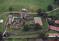
Kisnána - aerial view: castle

Tarnaméra: Almássí Castle

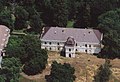
Pétervására Palace

Noszvaj
Palace de la Motte
Mátraderecske - castle
Noszvaj Castle
Aerial view: Erdőtelek - PalaST

Feldebrő Church


Web links
- Heves County Self-Government (Hungarian)
Individual evidence
- ↑ a b c 6.1.1. Resident population by sex, January 1st (2001-) (STADAT table). KSH, accessed February 13, 2017 .
- ↑ Gazetteer of Hungary, 1st January, 2013. (PDF) KSH, accessed on February 13, 2017 (Hungarian / English, also XLS file).
- ^ Detailed Gazetteer of Hungary. KSH, accessed February 13, 2017 (Hungarian / English).
- ↑ KSH: Gazetteer of Hungary, 1st January, 2016. In: Minden helység adata. KSH, accessed on March 7, 2017 (Hungarian / English, also PDF file).
- ↑ Heves County Museum Directorate HMMI (Heves Megyei Múzeumok Igazgatósága)
Bács-Kiskun | Baranya | Békés | Borsod-Abaúj-Zemplén | Budapest | Csongrád-Csanád | Fejér | Győr-Moson-Sopron | Hajdú-Bihar | Heves | Jász-Nagykun-Szolnok | Komárom-Esztergom | Nógrád | Plague | Somogy | Szabolcs-Szatmár-Bereg | Tolna | Vas | Veszprém | Zala
Bélapátfalva | Eger | Füzesabony | Gyöngyös | Hatvan | Heves | Pétervására
Coordinates: 47 ° 50 ' N , 20 ° 16' E