Mátra mountains
| Mátra | |
|---|---|
| Highest peak | Kékes (1015 m) |
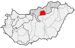
| location | Heves county , Nógrád county , northern Hungary approx. 60 km east of the Danube |
| Coordinates | 47 ° 53 ' N , 19 ° 56' E |
| particularities | Highest low mountain range in Hungary |
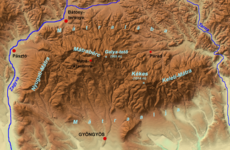
The Mátra Mountains are a low mountain range in northern Hungary . The area between the rivers Zagyva and Tarna and mainly made up of trachyte formed an island in the drying Pannonian Sea for a long time. The highest point is the Kékes with 1015 meters also the highest mountain in Hungary. The most important urban center of the area is Gyöngyös , a city with approximately 35,000 inhabitants; it is to Eger , the second largest city of the county Heves , where the mountain is located. In the east the Bükk low mountain range and in the west the hill country of Cserhát adjoin the Mátra mountains.
The densely wooded (especially beech and oak forests), very well developed tourist area is rich in climatic health resorts and spas. Mátraháza , Mátrafüred and Galyatető are the best known. The Zagyva river, which drains into the Tisza , is popular with canoeists.
In addition to tourism, viticulture is the livelihood of the rural population. On the southern slopes in particular, a number of appealing wines are pressed mainly on rhyolite - but also marl and loess soils . Traminer and Muscatel wines can mature to a remarkable quality in good years. However, the region is famous for the linden leaf from Debrő . This was mostly sweet to semi-sweet and often only delivered modest qualities. In addition to various blends, very good to outstanding single-variety wines from the Hárslevelű are offered again today .
Places and districts
- Abasar
- Bátonyterenye
- Bodony
- Domoszló
- Dorogháza
-
Gyöngyös
- Kékestet ő, Mátrafüred , Mátraháza
- Gyöngyösoroszi
- Gyöngyöspata
- Gyöngyössolymos
- Gyöngyöstarján
- Kisnána
- Markaz
- Mátraballa
- Mátraderecske
- Mátramindszent
- Mátraszentimre (highest place in Hungary)
- Pálosvörösmart
- Parád
- Parádsasvár
- Pásztó
- Recsk
- Sirok
- Szuha
- Szurdokpüspöki
- Tar
- Tarnaszentmária
- Verpelét


