
Pásztó
| Pásztó | |||||
|
|||||
| Basic data | |||||
|---|---|---|---|---|---|
| State : | Hungary | ||||
| Region : | Northern Hungary | ||||
| County : | Nógrád | ||||
| Small area until December 31, 2012 : | Pásztó | ||||
| Coordinates : | 47 ° 55 ' N , 19 ° 42' E | ||||
| Area : | 72.60 km² | ||||
| Residents : | 9,626 (Jan 1, 2011) | ||||
| Population density : | 133 inhabitants per km² | ||||
| Telephone code : | (+36) 32 | ||||
| Postal code : | 3060 | ||||
| KSH kódja: | 07409 | ||||
| Structure and administration (as of 2015) | |||||
| Community type : | city | ||||
| Mayor : | Dömsödi Gábor (independent) | ||||
| Postal address : | Kölcsey Ferenc utca 35 3060 Pásztó |
||||
| Website : | |||||
| (Source: A Magyar Köztársaság helységnévkönyve 2011. január 1st at Központi statisztikai hivatal ) | |||||


Pásztó is a town at the western foot of the Mátra , on the Zagyva River . It is the administrative seat of the small area of the same name (until 2012) and the Pásztó district (from 2013). Part of the Mátra Mountains, 7 kilometers away, and the village of Szurdokpüspöki, 5 kilometers away, belong to the Pásztó District.
The city has three churches, an outdoor swimming pool, a hospital, a fire station and a police station .
The place is on the railway line and the national road 21 between Salgótarján and Hatvan .
history
There was already a settlement here at the time of the Great Migration . In later documents the name was used in the forms Pasto, Pastro, Pastuch, Paastuchov, Paszthow, Patzhoh .

King Béla III. founded a Cistercian abbey in Pásztó in 1190 , from which the rural population was Christianized. After the destruction in the Mongol storm , the church, monastery and courtyards were rebuilt by the monks. In the 13th century the princes Rátót (de genere Ratold) became masters of Pásztó. The place received restricted city rights in 1298. With a letter of protection, King Sigismund gave the citizens the right to the Ofner statutes in 1407 . The place developed into a cultural and administrative center. The medieval school was notable in the 15th century. The prosperity of Pásztó came to an end with the conquest by the Turks. The place was uninhabited for over a hundred years. Life returned in the 1650s. At the instigation of Leopold I , Cistercian monks came to Pásztó from Moravia . In 1715 the baroque monastery buildings that still exist today were built. Joseph II abolished the monastery in 1787. In 1802 it got its original rights back.
In 1867 the city got a railway connection. But industry worth mentioning is not developing. In 1871 the place lost its town charter. In 1910 there were 5,792 inhabitants, 5,730 of them Hungarians and 5094 of them Roman Catholic, 95 Protestant and 529 Jewish. The following localities have belonged to Pásztó since the beginning of the 20th century: Alsóhuta, Felsőhuta, (formerly Almássy-huta), Fiskalitás huta and Ötházhuta.
With the administrative reform of 1950 Pásztó moved from Heves County to Nógrád County and lost the district seat . In the 1960s, the population increased due to the establishment of new development areas. In 1984 Pásztó received town charter.
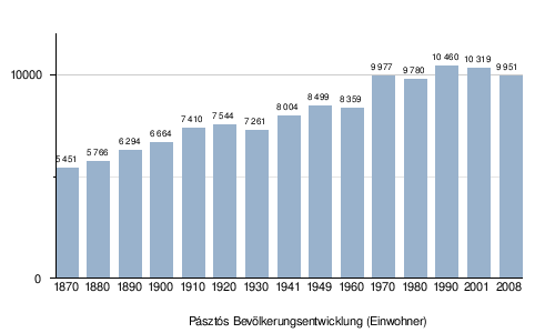
population
In 2001 97.5 percent of the population were Hungarians, 2 percent Roma and 0.5 percent Slovak .
Source: nepszamlalas.hu
Attractions

- monastery
- Kálmán Csohány Gallery
- Parish Church of Saint Lőrinc
- Schoolmaster's House ( Oskolamester háza , first mentioned in 1428)
- The Pásztó Museum
sons and daughters of the town
- Dezső Vértesy (1881–1917) philologist, translator
- Ilstván Kozma (* 1964) football player.
Town twinning
Web links
Pages in Hungarian:
swell
Translated from Hungarian
- ↑ A népesség számának alakulása, terület, népsűrűség, 1870–2001 ( Hungarian ) nepszamlalas.hu/. Archived from the original on April 18, 2005. Retrieved September 24, 2019.