
Lőrinci
| Lőrinci | |||||
|
|||||
| Basic data | |||||
|---|---|---|---|---|---|
| State : | Hungary | ||||
| Region : | Northern Hungary | ||||
| County : | Heves | ||||
| Small area until December 31, 2012 : | Hatvan | ||||
| District since 1.1.2013 : | Hatvan | ||||
| Coordinates : | 47 ° 44 ' N , 19 ° 41' E | ||||
| Area : | 23.53 km² | ||||
| Residents : | 5,969 (Jan 1, 2011) | ||||
| Population density : | 254 inhabitants per km² | ||||
| Telephone code : | (+36) 37 | ||||
| Postal code : | 3021 | ||||
| KSH kódja: | 30401 | ||||
| Structure and administration (as of 2020) | |||||
| Community type : | city | ||||
| Mayor : | Zoltán Víg (non-party) | ||||
| Postal address : | Szabadság tér 21. 3021 Lőrinci |
||||
| Website : | |||||
| (Source: A Magyar Köztársaság helységnévkönyve 2011. január 1st at Központi statisztikai hivatal ) | |||||


Lőrinci is a Hungarian town in the county Hatvan in Heves county .
geography
Lőrinci extends over an area of 25.53 km². The city lies on the Zagyva River at the western foot of the Mátra and on the border with the Great Hungarian Plain . From north to south the city is divided into Selyp , Lőrinci and the settlement at the power station .

history
The first written mention was in 1267 as ecclesia de Laurencio . Around the same time the village of Selyp was founded. In 1544 the places were occupied by the Turks and belonged to Sanjak Hatvan. In the 15th century the place became part of the diocese of Oradea, and in 1730 it was owned by the Grassalkovich family.
A salt office was also set up in the village .
With the opening of the Pest - Hatvan - License - Neusohl railway line in 1867, industrialization began: in 1881 a steam mill was built. In 1889 the Selyper sugar factory was founded. In 1908 a cement factory was built in Lőrinci. Significant was the opening of the Mátra power plant (Mátravidéki Erőmű) in 1940. With the territorial reform in 1950, the places changed from Nógrád County (Nógrád vármegye) to Heves County . In 1992 the place received city rights.
In 1998 the sugar factory was shut down.
population
In 2001, 97% of the population was Hungarian, while 3% said they belonged to the Roma population .
traffic
The place has two stations and a stop on the railway line 81 ( Hatvan - Salgótarján - Somoskőújfalu - ( Fiľakovo )) and is located on the national road 21 between Hatvan and Somoskőújfalu.
Attractions

- Michaels Church Lőrinci
- The Saint Anne Chapel on the Zagyva
- The Tornyay Schlossberger Castle in Selyp
- The local museum in Lőrinci
Twin cities

-
 Casalmaggiore , Italy
-
 Zduńska Wola , Poland
-
 St. Lorenz , Austria
-
Santa Maria di Licodia , Italy
photos
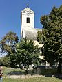
The Michaels Church

The Michaels Church

The local museum

The Saint Anne Chapel

The Trianon monument


Web links
- Website of the city of Lőrinci. Retrieved August 9, 2017 (Hungarian).
Individual evidence
- ↑ A 2001-es népszámlálás nemzetiségi adatsora ( Memento of the original from January 18, 2010 on WebCite ) Info: The archive link was inserted automatically and not yet checked. Please check the original and archive link according to the instructions and then remove this notice.
- ↑ Lőrinci testvérvárosai a város hivatalos oldalán . Retrieved August 9, 2017.