
Tatabánya
| Tatabánya | |||||
|
|||||
| Basic data | |||||
|---|---|---|---|---|---|
| State : | Hungary | ||||
| Region : | Central Transdanubia | ||||
| County : | Komárom-Esztergom | ||||
| Small area until December 31, 2012 : | Tatabánya | ||||
| Coordinates : | 47 ° 35 ' N , 18 ° 24' E | ||||
| Area : | 91.43 km² | ||||
| Residents : | 70,164 (Jan. 1, 2011) | ||||
| Population density : | 767 inhabitants per km² | ||||
| Telephone code : | (+36) 34 | ||||
| Postal code : | 2800 | ||||
| KSH kódja: | 18157 | ||||
| Structure and administration (as of 2013) | |||||
| Community type : | city | ||||
| Mayor : | Szücsné Posztovics Ilona (DK-JOBBIK-LMP-MSZP-MOMENTUM-PÁ) | ||||
| Postal address : | Fő tér 6 2800 Tatabánya |
||||
| Website : | |||||
| (Source: A Magyar Köztársaság helységnévkönyve 2011. január 1st at Központi statisztikai hivatal ) | |||||


Tatabánya [ ˈtɒtɒbaːɲɒ ] (German Totiser Colony ) is a town with county law and the seat of Komárom-Esztergom County in northwest Hungary with around 70,000 inhabitants. The city is located 52 km west of Budapest. Its location makes it a transport hub. The M1 motorway ( European roads E 60 , E 75 ) touches Vienna - Budapest , the railway line Vienna - Budapest runs through the city.
history


Traces of people can not only be found here from prehistoric times, the peoples of the Celts , Romans , Goths and Lombards were once resident here. Remains from the time of the Huns around 900 AD have also been discovered here.
Until around 1700 the area was hardly inhabited due to the Turkish wars. From 1727 the land belonged to Count József Eszterházy , who in 1733 called settlers from the Holy Roman Empire of the German Nation into the country.
The three historical predecessor settlements of the city are Untergalla (Alsógalla), Obergalla (Felsőgalla) and Bánhida. Untergalla was built up from 1733, Obergalla from 1735 by the settled Germans. After the mines were developed after 1900, a mining colony was established and later the Tatabánya community. On October 10, 1947, the four parishes Obergalla, Untergalla, Bánhida and Tatabánya were united to the city of Tatabánya.
The former district Partizántelep (German partisan settlement ) was built around 1940 for the miners and existed until the 1970s.
The industrial character of the city dominated until Hungary's political change. Since then, the importance of heavy industry and mining has declined significantly, and the city's economic structure has changed.


Districts today
Tatabánya is divided into six districts:
- Alsógalla (Lower Galla )
- Újváros (New Town)
- Bánhida (Weinhied)
- Kertváros (garden city)
- Dózsakert (Dózsa Garden)
- Felsőgalla (Obergalla)
Sports
The city's well-known football club is FC Tatabánya . Successes achieved and the handball team TATABÁNYA KC where the earlier the TBV Lemgo in the Handball Bundesliga active Laszlo Marosi has worked as sports director now. FC Tatabánya achieved international fame in 1986 when the choirs could be heard on television during a European Cup match against Rapid Vienna .
Closer villages
There are several villages near the town of Tatabánya:
- Gyermely
- Héreg
- Környe (Eng. Kirne)
- Szárliget
- Szomor (German Sumur)
- Tarján (Eng. Tarian)
- Várgesztes (German Gestitz)
- Vértessomló (Eng. Schemling)
- Vértesszőlős
Attractions
- Mari Jászai Theater
- Memorial Turulmadár ( Turulvogel ); largest bird statue in Europe (wing width 15 m).
- Selim cave
- Geretsche ( Gerecse ) Mountains and the natural landscape there

Selim cave, top view
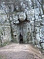
Selim Cave, north entrance

Selim cave, view from the inside


Town twinning
-
 Aalen , Germany , since 1987
 -
 Banská Štiavnica , Slovakia , since 2017
 -
 Będzin , Poland , since 2000
 -
 Christchurch , England , since 1992
 -
 Izhevsk , Russia , since 1992
 -
 Odorheiu Secuiesc , Romania , since 2000
 -
 Pyjterfolwo (Пийтерфолво), Ukraine , since 2015
City friendships
- Nové Zámky ( Slovakia )
- Saint-Ghislain ( Belgium )
- Saint-Lô ( France )
- Hoogezand-Sappemeer ( Netherlands )
sons and daughters of the town
- Márta Záray (1926-2001), singer
- Viktor Lois (* 1950), sculptor, installation and multimedia artist
- Viktor Kassai (* 1975), football referee
- Robert Koch (* 1976), volleyball player
- Nóra Medvegy (* 1977), chess player
- Miklós Fehér (1979-2004), football player
- Dávid Katzirz (* 1980), handball player
- László Gonda (* 1988), chess player
- Zsófia Tóth (* 1989), dual and triathlete
Web links
- City website
- Links to Tatabánya
- City partnership Aalen
- Mari Jászai Theater (Hungarian)
- Aerial views over Tatabánya
Individual evidence
- ↑ Tatabánya. City of Aalen, accessed April 7, 2018 .
- ↑ Testvérvárosok. (No longer available online.) Tatabánya Város Honlapja, October 19, 2017, archived from the original on March 12, 2018 ; Retrieved April 7, 2018 (Hungarian). Info: The archive link was inserted automatically and has not yet been checked. Please check the original and archive link according to the instructions and then remove this notice.