
Szomor
| Szomor | |||||
|
|||||
| Basic data | |||||
|---|---|---|---|---|---|
| State : | Hungary | ||||
| Region : | Central Transdanubia | ||||
| County : | Komárom-Esztergom | ||||
| Small area until December 31, 2012 : | Tatabánya | ||||
| District since 1.1.2013 : | Tatabánya | ||||
| Coordinates : | 47 ° 36 ' N , 18 ° 40' E | ||||
| Area : | 13.2 km² | ||||
| Residents : | 1,138 (Jan 1, 2011) | ||||
| Population density : | 86 inhabitants per km² | ||||
| Telephone code : | (+36) 34 | ||||
| Postal code : | 2822 | ||||
| KSH kódja: | 21421 | ||||
| Structure and administration (as of 2020) | |||||
| Community type : | local community | ||||
| Structure : | Szomor, Somodorpuszta | ||||
| Mayor : | György Nagy (independent) | ||||
| Postal address : | Vörösmarty Mihály u. 3 2822 Szomor |
||||
| Website : | |||||
| (Source: A Magyar Köztársaság helységnévkönyve 2011. január 1st at Központi statisztikai hivatal ) | |||||


Szomor is a Hungarian community in the county Tatabánya in Komárom-Esztergom . The eastern part of Somodorpuszta belongs to the municipality.
Geographical location
Szomor is located 20 kilometers east of the district town of Tatabánya . Neighboring communities are Gyermely in the west and the town of Zsámbék , which is six kilometers to the southeast.
history
The Szomor area was already inhabited in Roman times. In the 19th century, an almost complete four-wheeled Roman carriage was found in the Somodorpuszta district, which was brought to the Hungarian National Museum . The name of the settlement was first mentioned during the Árpád era in the 13th century. In the Great Turkish War , the place was destroyed and then rebuilt. Szomor is a former German farming village about 7 km from Schambek and is one of the four villages in the county (Máriahalom, Leányvár and Környe ) from which an expulsion took place. In 1945 about 30 of the 900 inhabitants were Magyars , the rest were Germans. About 650 people were expelled to Germany on April 12, 1946 (Dachau, Schwäbisch Gemünd, Böblingen, Karlsruhe, Heidelberg).
Attractions
- Calvary on Kakukk-hegy
- Nepomuki Szent János statue ( Nepomuki Szent János-szobor ), created 1807 (late baroque)
- Roman Catholic Church Szent Mihály , built after 1759 (Baroque)
- Roman Catholic cemetery chapel Sarlós Boldogasszony , built in 1811 (late baroque)
- Kézdy-Vásárhelyi Castle ( Kézdy-Vásárhelyi-kastély )
- World War Monuments ( Világháborús emlékművek )
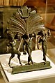
Bronze ornament of a Roman carriage found in Somodorpuszta
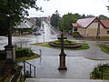
Center, right the community center
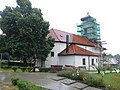
Roman Catholic Szent Mihály Church

Steeple dome

Nepomuki Szent János statue


traffic
Roads No. 1105 and No. 1123 meet in Szomor, and a side road leads to the Somodorpuszta district. The closest train station is in Tatabánya.
literature
- Szomor Község Településképi Arculati Kézikönyve. Edited by the municipal administration, Szomor 2019.
Individual evidence
- ↑ Helyi önkormányzati választások 2019 - Szomor (Komárom-Esztergom megye). Nemzeti Választási Iroda, accessed July 9, 2020 (Hungarian).
- ↑ Magyarország helységnévtára: Szomor. Központi Statisztikai Hivatal, accessed on July 9, 2020 (Hungarian).
- ^ German traces along the Danube. Donauschwäbisches Zentralmuseum Foundation, 2020, accessed on July 8, 2020 .
- ^ The situation of the German population in Szomor up to the invasion of the Red Army and their evacuation after the reconquest of the place by German troops in January 1945. http://doku.zentrum-gegen-vertrieb.de/ , May 4, 1953, accessed on July 8, 2020 .
- ^ The portal of the Hungarian Germans - Szomor. Anton Tressel, 2013, accessed July 8, 2020 .
- ↑ home. Soft grief over the last Kiritog of the Shambekers. Heidenheimer Zeitung, June 23, 2015, accessed on July 8, 2020 .
Web links
- Official website ( Hungarian )
- Szomor (Hungarian)
- Szomor kálvaŕia bei csendhegyek (Hungarian)