Nové Zámky
| Nové Zámky | ||
|---|---|---|
| coat of arms | map | |

|
|
|
| Basic data | ||
| State : | Slovakia | |
| Kraj : | Nitriansky kraj | |
| Okres : | Nové Zámky | |
| Region : | Nitra | |
| Area : | 72.565 km² | |
| Residents : | 37,512 (Dec. 31, 2019) | |
| Population density : | 517 inhabitants per km² | |
| Height : | 118 m nm | |
| Postal code : | 940 01 | |
| Telephone code : | 0 35 | |
| Geographic location : | 47 ° 59 ' N , 18 ° 10' E | |
| License plate : | NZ | |
| Kód obce : | 503011 | |
| structure | ||
| Community type : | city | |
| Urban area structure: | 2 cadastral communities | |
| Administration (as of November 2018) | ||
| Mayor : | Otokar Klein | |
| Address: | Mestský úrad Nové Zámky Hlavné námestie 10 94035 Nové Zámky |
|
| Website: | www.novezamky.sk | |
| Statistics information on statistics.sk | ||
Nové Zámky (German Neuhäus [e] l , Hungarian Érsekújvár , Ottoman Uyvar ) is a town in southern Slovakia and gives a district its name.
geography
location
The place is an important center in the Danube Plain and used to be an important fortress. The city is located 100 km east of Bratislava about 25 km north of the Hungarian border at an altitude of 119 m on the Nitra River .
structure
The place consists of the actual city Nové Zámky and the incorporated town Nový Gúg .
climate
The city is located in the temperate climate zone and there is a continental climate . The average annual temperature is around 10 ° C, with the warmest month July at 20 ° C and the coldest in January at −2 ° C. The average rainfall is 556 mm.
history
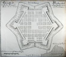
The place arose after 1545 next to a castle that was built to protect against the Ottomans . It was mentioned for the first time in 1571 as Uyuar , and from 1573–1581 the castle was converted into a six-pointed fortress with six bastions. After ten unsuccessful sieges, it fell into the hands of the Turks in the Turkish War of 1663/1664 . Until it was recaptured by Austrian troops in 1685, the city was the center of an Ottoman Eyâlet . After the Turkish threat was finally averted in 1699 and 1718, but the facilities had played a role in anti-Habsburg uprisings , Charles VI let them . Grind 1724/25.
Until 1918 the city belonged to the Kingdom of Hungary and then came to the newly formed Czechoslovakia . She came back to Hungary for a short time from 1938 to 1945 through the First Vienna Arbitration . During the Second World War , the city was the target of Allied bombing attacks and was badly damaged.
In recent years, German companies from the mechanical engineering and automotive supplier industries have settled here. Osram is represented here, among others .
Attractions
- Remains of the fortifications (Castrum Novum) hexagonal, star-shaped floor plan (Žerotín, Michaels, Imperial, Bohemian, Ernst and Forgách bastions)
- Church of the Franciscan monastery, baroque style from the middle of the 17th century
- other Protestant, Reformed and Catholic churches and a synagogue from the 17th to 20th centuries
- Ernest Zmeták art gallery with European art from the 16th to the 20th century.
traffic
The city is an important traffic junction in southern Slovakia.
Personalities
- Charles Bonaventure de Longueval (1571–1621), Field Marshal
- György Pray (1723–1801), historian and Jesuit
- Anton Bernolák (1762-1813), linguist
- Ferenc Helbing (1870–1958), artist
- Lajos Kassák (1887–1967), writer and painter
- Lucien Aigner (1901–1989/1999), photographer
- Ladislav Pataki (1946–2007), track and field athlete, trainer and sports scientist
- Klára Kuzmová (* 1955), archaeologist
- Henrieta Nagyová (* 1978), tennis player
- Martina Suchá (* 1980), tennis player
- Arnold Šimonek (* 1990), football player
Twin cities
literature
- Georg Kreckvitz, Totius Regni Hungariae ... descriptio , p. 1216ff Digital copy of the siege of Neuheusel 1685
Individual evidence
- ↑ Archived copy ( Memento from September 8, 2012 in the web archive archive.today ) (slovak.)
Web links
- Historical map from 1627: Demolition of the Neuheusel fortress How those were besieged by Käyserlicher Maÿestät Armada and General Bocquoÿ ( digitized version )
- Illustration by Lukas Schnitzer from 1665: Neuhäusel besieged by the Turks ( digitized version )
- Illustration by Lukas Schnitzer from 1665: Neuhausel ( digitized version )
- Official website in Slovak
- Nové Zámky Photo Album Slovak


