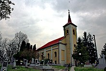
Dolný Ohaj
| Dolný Ohaj | ||
|---|---|---|
| coat of arms | map | |

|
|
|
| Basic data | ||
| State : | Slovakia | |
| Kraj : | Nitriansky kraj | |
| Okres : | Nové Zámky | |
| Region : | Nitra | |
| Area : | 17.028 km² | |
| Residents : | 1,547 (Dec 31, 2019) | |
| Population density : | 91 inhabitants per km² | |
| Height : | 123 m nm | |
| Postal code : | 941 43 | |
| Telephone code : | 0 35 | |
| Geographic location : | 48 ° 5 ' N , 18 ° 15' E | |
| License plate : | NZ | |
| Kód obce : | 503151 | |
| structure | ||
| Community type : | local community | |
| Administration (as of November 2018) | ||
| Mayor : | Ivan Solár | |
| Address: | Obecný úrad Dolný Ohaj Hlavná 109/130 941 43 Dolný Ohaj |
|
| Website: | www.obecdolnyohaj.sk | |
| Statistics information on statistics.sk | ||
Dolný Ohaj (Hungarian Ohaj ) is a medium-sized town in the west of Slovakia with a population of 1,547 (December 31, 2019) that the Nové Zámky District , a circle of Nitriansky kraj heard.
geography
The municipality is located in the Danube lowlands on the left bank of the Žitava . The center of the village lies at an altitude of 123 m nm and is eight kilometers from Šurany and 19 kilometers from Nové Zámky .
Neighboring municipalities are Hul in the north, Veľké Lovce in the east, Bešeňov in the south, Bánov in the southwest, Šurany ( Nitriansky Hrádok district ) in the west and Úľany nad Žitavou in the northwest.
history
The municipality was inhabited in the New Stone Age, with the remains of a settlement of the Želiezovce culture , finds from the Baden culture and from a Great Moravian Slavic settlement.
The place itself was first mentioned in writing as Vhay in 1293 and belonged mostly to the local nobles, a small part to the regional lower nobility. Over the centuries members of the Mariássy , Festetics and Szemere families were lords. After the area was largely depopulated during the Turkish wars in the 17th century, the village had to be repopulated in the 18th century by settlers from the area and Moravia. In 1828, together with the former village Veľký Ohaj ( Nagyohaj in Hungarian ), 147 houses and 980 inhabitants were employed in agriculture. In 1894 a distillery and starch factory were built here, and there was also a roller mill here.
Until 1918/1919, the place in Bars County belonged to the Kingdom of Hungary and then came to Czechoslovakia or now Slovakia. Due to the First Vienna Arbitration Award , he was again in Hungary from 1938 to 1945.
population
According to the 2011 census, there were 1,600 inhabitants in Dolný Ohaj, of which 1,550 were Slovaks, eight Magyars, three Czechs, two Moravians and one Roma and one Serbian each. 35 residents gave no information in this regard. 1520 residents confessed to the Roman Catholic Church, eight residents to the Evangelical Church AB, two residents to the Orthodox Church and one resident each to the Old Catholic Church and one to the Greek Catholic Church; two residents professed a different denomination. 28 residents had no denomination and 38 residents had no denomination.
Buildings
- Roman Catholic Holy Family Church from 1873
- Baroque style chapel from the 18th century
Individual evidence
- ↑ 2011 census by ethnicity (Slovak) ( Memento from October 6, 2014 in the Internet Archive )
- ↑ 2011 census by denomination (Slovak) ( Memento from September 7, 2012 in the Internet Archive )
Web links
- Entry on e-obce.sk (Slovak)

