Bardoňovo
| Bardoňovo Baracska |
||
|---|---|---|
| coat of arms | map | |

|
|
|
| Basic data | ||
| State : | Slovakia | |
| Kraj : | Nitriansky kraj | |
| Okres : | Nové Zámky | |
| Region : | Nitra | |
| Area : | 23.81 km² | |
| Residents : | 687 (Dec. 31, 2019) | |
| Population density : | 29 inhabitants per km² | |
| Height : | 193 m nm | |
| Postal code : | 941 49 | |
| Telephone code : | 0 35 | |
| Geographic location : | 48 ° 7 ' N , 18 ° 26' E | |
| License plate : | NZ | |
| Kód obce : | 503053 | |
| structure | ||
| Community type : | local community | |
| Administration (as of November 2018) | ||
| Mayor : | Tibor Černák | |
| Address: | Obecný úrad Bardoňovo č. 77 941 49 Bardoňovo |
|
| Website: | www.obecbardonovo.sk | |
| Statistics information on statistics.sk | ||
Bardoňovo (until 1948 Slovak "Baračka"; Hungarian Baracska or Barsbaracska ) is a municipality in the west of Slovakia with 687 inhabitants (December 31, 2019) that the Nové Zámky District of, a circle Nitriansky kraj heard.
geography
The municipality is located in the Slovak Danube lowlands , within its subunit Pohronská pahorkatina , in the gentle valley of the small brook Kvetnianka . The center of the village is at an altitude of 193 m nm and is 21 kilometers from Šurany , 24 kilometers from Levice and 34 kilometers from Nové Zámky .
Neighboring municipalities are Beša in the north, Dolný Pial in the northeast, Tekovské Lužany in the east, Plavé Vozokany in the south, Dedinka in the southwest, Pozba in the west and Trávnica in the northwest.
history
According to archaeological investigations, there was a burial site of the hill burial culture (more precisely the Čaka culture and Velatice culture) from the Middle Bronze Age and a settlement from the Roman era in the present municipality area.
The place was first mentioned in writing in 1269 as Barakcha and was partly owned by the local landed gentry and partly owned by the Hronský Beňadik Abbey . During the Turkish wars, the village was affected several times. In 1601 there was a Meierhof and 44 houses, in 1715 the village had vineyards and 23 taxpayers, in 1828 there were 84 houses and 591 residents who were employed as farmers and winemakers.
Until 1918/1919, the place in Bars County belonged to the Kingdom of Hungary and then came to Czechoslovakia or now Slovakia. In the first Czechoslovak republic there were large estates of the Kelecsényi and Hoffer families here . Due to the First Vienna Arbitration Award , he was again in Hungary from 1938 to 1945.
population
According to the 2011 census, 786 people lived in Bardoňovo, of which 454 were Slovaks , 233 Magyars and five Czechs . 94 inhabitants did not provide any information on ethnicity .
386 residents committed themselves to the Roman Catholic Church, 185 residents to the Reformed Church, four residents to the Evangelical Church AB, two residents to the Evangelical Methodist Church and one resident to the Greek Catholic Church. 105 inhabitants were without a denomination and the denomination of 103 inhabitants was not determined.
Buildings
- Roman Catholic Church of St. Bartholomew in Baroque style from 1733
- Reformed Church from 1909
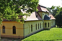
- Country castle of the Kelecsényi family in neo-baroque style with a park from 1888, which was created by expanding an earlier country seat
Individual evidence
- ↑ Slovenské slovníky: názvy obcí Slovenskej republiky (Majtán 1998)
- ↑ Results of the 2011 census (Slovak)
Web links
- Entry on e-obce.sk (Slovak)


