Nitriansky kraj
| Nitriansky kraj | |||
|
|||
| Parent state | Slovakia | ||
| Type of administrative unit | Kraj | ||
| Administrative division | 7 okresy | ||
| surface | 6,344 km² | ||
| Residents | 674,306 (December 31, 2019) | ||
| Population density | 106.29 inhabitants / km² | ||
| Language (s) | Slovak , Hungarian | ||
| Religion (s) | Roman Catholic | ||
| Nationality (s) | Slovaks , Hungary | ||
| Administrative seat / capital | Nitra | ||
| Code number / character | 04 | ||
| Telephone code | +421 | ||
| Time zone | UTC +1 | ||
| Code according to ISO 3166-2 | SK-NI | ||
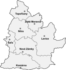
The Nitriansky kraj ( Neutraer Landschaftsverband ) is an administrative area (landscape association) in southwestern Slovakia .
Districts
The Kraj consists of the following 7 districts ( okresy ):
- Komarno
- Levice
- Nitra
- Nové Zámky (including Štúrovo )
- Aľa
- Topoľčany
- Zlaté Moravce
geography

The Kraj has 6,344 km² and 674,306 inhabitants (as of December 31, 2019). The landscape is largely covered by the great Danube lowlands; the south-western part of this lowland is covered by the Danube plain (including the Große Schüttinsel ) and the rest belongs to the Danube hill country . In the northern half of the Kraj there are also some mountains, but all below 1000 m nm : in the northwest the Inowetz , then the Tribeč north of Nitra , Pohronský Inovec in the northeast and Štiavnické vrchy (German Schemnitz Mountains) in the east. Important rivers are the great Danube in the south, which also forms the state border with Hungary, the Waag with the Little Danube in the southwest, the Nitra through the west, the Hron in the east and the border river Ipeľ in the southeast. The highest mountain is Veľký Inovec in Pohronský Inovec ( 901 m nm ); the lowest point is on the Danube at Chľaba , where the river leaves Slovakia ( 102 m nm ).
There are three protected landscape areas in the Kraj: Dunajské luhy (Danube meadows), Ponitrie (Nitra region, here: Tribeč ) and Štiavnické vrchy .
Administratively, the Kraj borders on Trenčiansky kraj in the north, Banskobystrický kraj in the east, Hungarian counties Nógrád and Pest in the south-east, counties Komárom-Esztergom and Győr-Moson-Sopron in the south and south-west, and Trnavský kraj in the west.
Historical administrative division
Historically, today's Kraj in the Kingdom of Hungary was divided into different counties: in the Nitra area and in the west was the Nitra county of the same name . Around the two towns of Zlaté Moravce and Levice was Persch County and to the east was part of Hont County . Along the Danube, the area belonged to Gran and Komorn counties . In the far west there were smaller parts of Pressburg County .
Development after the collapse of Austria-Hungary in 1918:
- 1918 / 1919–1922: as above, only the Slovak part of Gran County was incorporated into Komorn County, Czechoslovakia
- 1923–1928: Bratislavská župa (Bratislava County), Nitrianska župa (Neutra County) and Zvolenská župa (Sohl County), Czechoslovakia
- 1928–1939: Slovenská krajina / zem (Slovak Land), Czechoslovakia
- 1940–1945: Nitrianska župa (Neutra County), First Slovak Republic . The southern part (south of the line and including Šaľa-Šurany-Vráble-Levice) was part of Hungary from 1938 to 1945 as a result of the First Vienna Arbitration .
- 1945–1948: Slovenská krajina (Slovak Land), Czechoslovakia
- 1949–1960: Bratislavský kraj (Bratislava district), Nitriansky kraj (Neutra district) and Banskobystrický kraj (Neusohl district) - they are not to be confused with today's, Czechoslovakia
- 1960–1990: Západoslovenský kraj (West Slovak District), Czechoslovakia
- since 1996: today's Nitriansky kraj
population
The population density is 108 / km², almost the same as the Slovak average (111 / km²). The regional capital is Nitra ( Neutra ); other medium- sized towns are Topoľčany ( Großtopoltschan ), Komárno ( Komorn ), Nové Zámky ( Neuhäusel ) and Levice ( Lewenz ). The regional association consists of a total of 354 municipalities , 15 of which are cities.
According to the 2011 census, exactly 689,867 people lived in Nitriansky kraj. The largest part was made up of the Slovaks (473,269 inh., 68.6%), followed by the Magyars (169,460 inh., 24.6%), Roma (3,987 inh., 0.6%) and the Czechs (3,262 in. , 0.5%). Other ethnic groups together make up 0.4% (2,893 inh.) Of the population, while 36,996 inhabitants (5.4%) gave no information about the ethnic group.
In terms of denominations, the Roman Catholic Church is the most widespread denomination with 486,021 inhabitants (70.5%), followed by the Reformed (Calvinist) Church (29,597 pop., 4.3%) and Evangelical Church AB (19,357 pop., 2 ,8th %). Furthermore, the population committed to the Greek Catholic Church (1,841 inhabitants, 0.3%), the Jehovah's Witnesses (1,765 inhabitants, 0.3%), the Methodist Church (1,256 inhabitants, 0.2%) ) and the Pentecost Movement (1,231 inh., 0.2%); a total of 6,402 inhabitants (0.9%) professed a different denomination. 82,488 inhabitants (12%) were non-denominational and 59,909 inhabitants (8.7%) had no denomination.
Web links
Individual evidence
- ^ Kopa, Ľudovít et al .: The Encyclopaedia of Slovakia and the Slovaks . Encyclopedic Institute of the Slovak Academy of Sciences ( Memento of June 26, 2008 in the Internet Archive ), Bratislava 2006, ISBN 80-224-0925-1 .
- ^ Kováč, Dušan et al .: Kronika Slovenska 2 . Fortuna Print, Bratislava 1999, ISBN 80-88980-08-9 .
- ↑ Statistical Office of the Slovak Republic ( Memento of the original dated February 26, 2011 in the Internet Archive ) Info: The archive link was inserted automatically and has not yet been checked. Please check the original and archive link according to the instructions and then remove this notice.
- ↑ Results of the 2011 census (Slovak)


