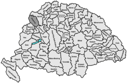
Pressburg county
|
Pressburg County (Pozsony) (1910) |
|
|---|---|

|
|
| Administrative headquarters : | Pozsony |
| Area : | 4,370 km² |
| Population : | 389,750 |
| Ethnic groups : | 43% Slovaks 42% Magyars 14% Germans 1% others (mainly Croatians ) |

|
|
The county Pressburg ( Hungarian Pozsony vármegye , Slovak Prešpurská stolica / župa or county Prešpurský , German and Pressburger County Latin comitatus Posoniensis ) is the name of a historic administrative unit ( county or county ) of the Kingdom of Hungary as well as the "County Bratislava" / " Bratislava County “(Slovakian Bratislavská župa ) of Czechoslovakia and the First Slovak Republic .
The area is now in western Slovakia , and the city of Pressburg is now called Bratislava . The names of the county changed with the name of the central city (see there ). Around 1900 the names Pozsonyi vármegye were in Hungarian, Bratislava County / Bratislava county in German and Prešpurská župa in Slovak.
location
Pressburg county bordered in the west on the Austrian crown land of Lower Austria , in the east and north on Neutra ( Nyitra ) county , in the south-east on Komorn ( Komárom ) county , in the south on Raab ( Győr ) county and in the south-west on Wieselburg county ( Moson ). It was bounded in the west by the March , in the south by the Danube and in the east by the Waag . In 1910 the county had 389,750 inhabitants on an area of 4370 km².
Administrative offices
The administrative headquarters of Pressburg County were originally Pressburg Castle and Sommerein , southeast of Pressburg, and from the 18th century the City of Pressburg .
history
A kind of predecessor of Pressburg County already existed in the 9th century during the rule of Great Moravia over this area. After Pressburg became part of the Kingdom of Hungary from 907 , the Hungarian county was established around the year 1000. It was one of the first to emerge in what was then the Hungarian Empire, and it extended roughly across the present day regional associations of Bratislava and Trnava . Favored by the location of the city of Pressburg and its proximity to Vienna , the county was always one of the richest and most progressive in the kingdom until the late 18th century. In the 18th and 19th centuries the population consisted mainly of Germans (in and around Pressburg and in the Little Carpathians), Slovaks (mainly in the north), Hungarians (mainly in the south along the Danube) and Croats (in the suburbs of Pressburg - especially east and south of the city).
After Pressburg became part of Czechoslovakia on January 1, 1919 ( confirmed under international law by the Treaty of Trianon 1920), the county remained as Bratislavská župa until 1927, but the competencies of this administrative area were completely different from the previous ones and also the Borders were changed slightly in 1923. A very small part south of the town of Šamorín on the right of the Danube remained with Hungary and came to Győr County, Moson és Pozsony (from 1945 Győr-Moson County and after the major county reform in 1950 until today Győr-Moson-Sopron County ).
From 1938 to 1945 the south-eastern half of the former Pressburg County was occupied by Hungary due to the First Vienna Arbitration . The part south of the Little Danube came to Komorn County , a small strip of land north of the Little Danube, which had also fallen to Hungary, became part of the newly created Hungarian county Nyitra-Pozsony with the capital Nové Zámky (Hungarian Érsekújvár ).
During the independence of Slovakia from 1939 to 1945, the administrative unit Bratislavská župa was re-established in 1940 in the Slovak part . After the war, Czechoslovakia was restored and dissolved again in 1993.
The administrative area of the county was incorporated chronologically as follows:
- 1918–1928: Bratislavská župa (Bratislava County), CS
- 1928–1939: Slovenská krajina / zem (Slovak Land), CS
- 1938–1945: Nyitra és Pozsony kee vármegye (provisionally unified administered counties Neutra and Pressburg), H (southern part)
- 1940–1945: Bratislavská župa (Bratislava County), SK (northern part)
- 1945–1948: Slovenská krajina (Slovak Country), CS
- 1949–1960: Bratislavský kraj (Bratislava Landscape Association - not to be confused with today's), CS
- 1960–1990: Západoslovenský kraj (West Slovak Regional Association) + since 1969/1971 Bratislava, capital of the Slovak Socialist Republic , CS
- since 1996: Bratislavský kraj (Bratislava Landscape Association) + Trnavský kraj (Tyrnau Landscape Association), SK
District subdivision
In the early 20th century the following chair districts existed (named after the name of the administrative seat):
| Chair districts (járások) | |
|---|---|
| Chair district | Administrative headquarters |
| Dunaszerdahely | Dunaszerdahely, today Dunajská Streda |
| Galánta | Galánta, today Galanta |
| Malacka | Malacka, today Malacky |
| Nagyszombat | Nagyszombat, today Trnava |
| Pozsony | Pozsony, now Bratislava |
| Somorja | Somorja, today Šamorín |
| Scene c | Zenc, today Senec |
| City district (törvényhatósági jogú város) | |
| Pozsony, now Bratislava | |
| City districts (rendezett tanácsú városok) | |
| Bazin, today Pezinok | |
| Modor, today Modra | |
| Nagyszombat, today Trnava | |
| Szentgyörgy, today Svätý Jur | |
See also
- List of traditional regions of Slovakia
- List of historical counties of Hungary
- Administrative division of Slovakia
literature
- Pressburg . In: Meyers Konversations-Lexikon . 4th edition. Volume 13, Verlag des Bibliographisches Institut, Leipzig / Vienna 1885–1892, p. 329.
Web links
- Entry in the Pallas Lexicon (Hungarian)
Individual evidence
- ↑ A magyar szent corona országainak 1910. évi népszámlálása . Budapest 1912, p. 12 ff.
- ↑ A magyar szent corona országainak 1910. évi népszámlálása . Budapest 1912, p. 22 ff. (1910 census)

