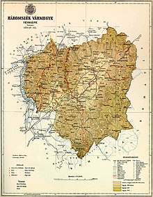
Háromszék county
|
Háromszék county (1910) |
|
|---|---|

|
|
| Administrative headquarters : | Sepsiscentgyörgy |
| Area : | 3,889 km² |
| Population : | 148.080 |
| Ethnic groups : | 83% Hungarians 15.5% Romanians 1.5% others ( Germans , Slovaks , Ruthenians ) |

|
|
The county Háromszék [ ˈhaːromseːk ] ( Hungarian Háromszék vármegye , Romanian Comitatul Trei-Scaune ) was an administrative unit of the Kingdom of Hungary in the Szeklerland in Transylvania . Most of the area is now in the Covasna County in central Romania .
geography
Háromszék county bordered on Old Romania and the Hungarian counties of Csík , Udvarhely , Groß-Kokelburg (Nagy-Küküllő) and Kronstadt (Brassó) . The Olt flows through the county . The southern and eastern sections are bounded by the Carpathian Mountains.
description
“To the south of Csiker County, in the southern corner of the Transylvanian Basin, lies Háromszék County, with an area of 3556.29 square kilometers. Its south-western part is crossed from north to south by the southernmost point of the Hargita, the so-called Hermanyer or Barot Mountains. Parallel to these mountains, but less deep, the county that follows the left old bank penetrates higher and rougher Bodok Mountains, with the Bodoker Alpe (1195 meters) as the highest peak. To the east of this the last foothills of the Esiker border mountain groups reach across into the northern part of the county. The highest in this group are the neighboring peaks of Nagy-Sándor (1628 meters) and Nemere (1628 meters). These mountains are separated by the Ojtoz Pass from the Bereczk Mountains accompanying the eastern border, which run as an uninterrupted massive mountain range from north to south. In this border chain, the Lakócza (1775 meters) is the highest peak, but Esiyános (1605 meters) forms the southernmost corner, where the entire eastern border mountains bend at a sharp angle to the west and cross the Baßkabach and extend to the Bodza Pass. The Bodzan Alps send only their extreme north-eastern branches to Háromszék, closing the extensive central plain of the county from the south. "
history
Literally translated, Háromszék means “three chairs”. Háromszék County was formed in 1876, when the administrative structure of Transylvania was changed, from the three Szekler chairs Kézdiszék , Orbaiszék and Sepsiszék (often called together as Háromszék ), parts of Fehér County (Száraspatak exclave) and other neighboring areas. In 1918 it became part of Romania under the name Trei Scaune , which also means "three chairs".
District subdivision
In the early 20th century, the county consisted of the following chair districts (named after the name of the administrative center):
| Chair districts (járások) | |
|---|---|
| Chair district | Administrative headquarters |
| Kézdi | Kézdivásárhely, today Târgu Secuiesc |
| Miklósvár, today Micloșoara | Nagyajta, today Aita Mare |
| Orbai | Kovászna, today Covasna |
| Sepsi | Sepsiszentgyörgy, today Sfântu Gheorghe |
| City districts (rendezett tanácsú városok) | |
| Kézdivásárhely, today Târgu Secuiesc | |
| Sepsiszentgyörgy, today Sfântu Gheorghe | |
All of the places mentioned are in what is now Romania .
See also
literature
- Háromszék . In: Meyers Konversations-Lexikon . 4th edition. Volume 8, Verlag des Bibliographisches Institut, Leipzig / Vienna 1885–1892, p. 176.
Web links
- Entry in the Pallas Lexicon (Hungarian)
- Entry on the county in the Catholic Lexicon (Hungarian)
- Entry on the area / chair in the Catholic Lexicon (Hungarian)
Individual evidence
- ↑ A magyar szent corona országainak 1910. évi népszámlálása . Budapest 1912, p. 12 ff.
- ↑ A magyar szent corona országainak 1910. évi népszámlálása . Budapest 1912, p. 22 ff. (1910 census)
- ↑ Krista Zech (Ed.): Transylvania in words and pictures . P. 344

