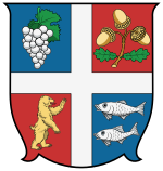
Bereg county
|
Bereg County (Berg) (1910) |
|
|---|---|

|
|
| Administrative headquarters : | Beregszász |
| Area : | 3,786 km² |
| Population : | 236.611 |
| Ethnic groups : | 48% Hungarians 43% Russians 9% Germans |

|
|
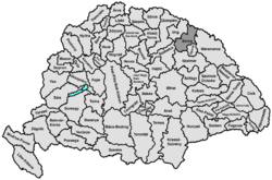
The Bereg County (German and County Mountain / Berger County ; Hungarian vármegye Bereg , Latin comitatus Beregiensis ) was an administrative unit ( county or county ) in the Kingdom of Hungary . Today the smaller part is in Hungary (in today's Szabolcs-Szatmár-Bereg County ), the larger part in the Ukraine ( Transcarpathian Oblast ).
location
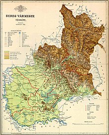
The county bordered in the north on the Austrian crown land Galicia (or before 1772 on Poland ), in the east on the county Máramaros , in the south-east on the small county Ugocsa , in the south on the county Sathmar (Szatmár) , in the south-west on the county Szabolcs and in the northwest to the Ung county .
It was located between the Carpathian Mountains in the north and the River Tisza in the south. In 1910 it had 208,589 inhabitants on an area of 3,783 km².
Up until 1621, Bereg County was known as Borsova County . From the flat part of the county to the south, the relief became increasingly mountainous towards the north-northeast. The highest mountain was the Stoj (Hungarian Sztoj , 1681 m), an important pass was the Verecke pass. The rivers Tisza , Serne , Latorica , Irschawa etc. flowed through the area of the county .
The 1910 census showed a population of 208,589 people. Among them were 93,198 (44.7%) Hungarians , 18,639 (8.9%) Germans and 95,308 (45.7%) Russians ("Ruthenians" in the language at the time). The Hungarians lived mainly in the plains near the Tisza, the Russians mostly in the mountains, less in the plains, and the Germans mainly in the towns or in smaller groups throughout the county. 103,206 people identified themselves as Uniate , 56,289 as Calvinists , 19,128 as Catholics (Roman) and 29,052 as Israelites .
District subdivision
In the early 20th century the following administrative division existed:
| Chair districts (járások) | |
|---|---|
| Chair district | Administrative headquarters |
| Alsóverecke | Alsóverecke, today Нижні Ворота / Nyschni Vorota |
| Felvidék ("Oberland") | Ilosva today Іршава / Irshava |
| Latorca, today Латориця / Latoryzja | Oroszvég, today Росвигово / Roswyhowo, district of Mukachevo |
| Mezőkaszony | Mezőkaszony, today Косонь / Kosson |
| Munkács | Munkács, today Мукачево / Mukachevo |
| Szolyva | Szolyva, today Свалява / Swaljawa |
| Tiszahát ("Tisza Ridge") | Beregszász, today Берегове / Berehowe |
| City districts (rendezett tanácsú városok) | |
| Beregszász, today Берегове / Berehowe | |
| Munkács, today Мукачево / Mukachevo | |
All places are in today's Ukraine .
literature
- Révai Nagy Lexikona, Volume 3
See also
Web links
- Entry on the county in Meyers Konversationslexikon from 1888
- Entry in the Pallas Lexicon (Hungarian)
Individual evidence
- ↑ A magyar szent corona országainak 1910. évi népszámlálása . Budapest 1912, p. 12 ff.
- ↑ A magyar szent corona országainak 1910. évi népszámlálása . Budapest 1912, p. 22 ff. (1910 census)

