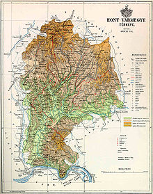
Hont county
|
Hont County (1910) |
|
|---|---|

|
|
| Administrative headquarters : | Ipolyság |
| Area : | 2,633 km² |
| Population : | 132,441 |
| Ethnic groups : | 55% Magyars 39% Slovaks 5% Germans |

|
|
Hont County (German also Honter County ; Hungarian Hont (h) vármegye , Slovak Hontianska župa , Latin comitatus Honthensis ) is the name of a historic administrative unit ( County / County ) in the Kingdom of Hungary for a short time and after 1918 in the area of Czechoslovakia .
3/4 of the area is in what is now southern Slovakia and 1/4 in northern Hungary . The name Hont is now used as the unofficial name for this area.
location
Hont county bordered Sohl ( Zólyom ) county to the north , Neograd ( Nógrád ) county to the east and south-east , Pest-Pilis-Solt-Kiskun county to the east and south along the Danube, and Gran county to the south-west ( Esztergom ) and to the west and northwest to Bars County .
It was roughly between the town of Banská Štiavnica (German Schemnitz ) and the Danube , but the area around the town of Krupina (German carp ) was not annexed until the end of the 19th century. The area was traversed by the rivers Krupinica and Eipel (Slovak Ipeľ , Hungarian Ipoly ) and in 1910 had 132,441 inhabitants on an area of 2633 km².
Administrative offices
Originally, the administrative seat of the county was Hont Castle (located in today's Hungary on the border with Slovakia, southeast of Šahy ) together with the town of Ipeľské Predmostie , from the 16th century during the Turkish occupation there was no real capital, and from the early 19th In the 17th century, Šahy (German Eipelschlag , Hungarian Ipolyság ) became the administrative center.
history
The county was created in the 11th century (first source reference 1156) by splitting off from Neograd county . Around the year 1300 the (not adjacent) area of Kleinhont (Hungarian Kishont ) was added, but this retained a special status and became part of Gemer and Kleinhont counties in 1802 (temporarily also 1786–1790) .
From 1552 to 1685 the majority of the county either direct component of the was Ottoman Empire (and was thence to a management unit, which as Sandschak was designated Neograd / NOGRAD) or was at least this realm opposite tributary.
At the time of the separation from Kleinhont in 1802 there were also small changes to the northern border, and in the late 19th century the area around Krupina was added to the county.
In 1918, most of the county (confirmed under international law by the Treaty of Trianon in 1920) became part of the newly formed Czechoslovakia , while a small part of the area southeast of the Eipel remained with Hungary .
The Czechoslovak part continued as Hontianska župa until 1922 . Due to the First Vienna Arbitral Award in 1938, the southern part was occupied by Hungary, and the northern part came from 1940 to 1945 to the newly founded Gran County (Slovak Hronská župa ) within the 1939-1945 independent Slovakia. The borders were restored after the end of the Second World War in 1945, as was Czechoslovakia . After the renewed division of Czechoslovakia in 1993, the area became independent Slovakia and has been in the Neutraer (Slovakian Nitriansky ) and the Neusohler Landschaftsverband (Slovakian Banskobystrický kraj ) since 1996 .
The area of the county was incorporated into Czechoslovakia chronologically as follows:
- 1918–1922: Hontianska župa (Hont County), CS
- 1923–1928: Zvolenská župa ((Old) Sohler County) + Nitrianska župa (Neutraer County), CS
- 1928–1939: Slovenská krajina / zem (Slovak Land), CS
- 1940–1945: Pohronská župa (Gran County), SK
- 1945–1948: Slovenská krajina (Slovak Country), CS
- 1949–1960: Banskobystrický kraj (Neusohler Landschaftsverband) + Nitriansky kraj (Neutraer Landschaftsverband) - not to be confused with today's, CS
- 1960–1990: Západoslovenský kraj (West Slovak Regional Association) + Stredoslovenský kraj (Central Slovak Regional Association), CS
*seit 1996: Banskobystrický kraj (Neusohler Landschaftsverband) + Nitriansky kraj (Neutraer Landschaftsverband), SK
After the end of the kingdom in 1918, the Hungarian part of Hont was united with Neograd County to form the new Nógrád-Hont County . From 1938 to 1945 it was combined with parts of the former, now occupied counties Bars and Hont to form Bars-Hont county , of which Levice became the capital . Since 1950 the Hungarian area of Hont has been divided between the Pest and Nógrád counties that still exist today .
District subdivision
Until 1802 the county consisted of three chair districts (Hungarian járások , Slovak slúžnovské okresy , Latin processus ) and the Kleinhont district. After Kleinhont was split off in 1802, the county was re-divided into four chair districts.
In the early 20th century, the county consisted of the following chair districts (named after the name of the administrative center):
| Chair districts (járások) | |
|---|---|
| Chair district | Administrative headquarters |
| Bát | Bát, today Bátovce |
| Ipolynyék | Ipolynyék, today Vinica |
| Ipolyság | Ipolyság, today Šahy |
| Corpona | Korpona, today Krupina |
| Szob | Szob |
| Vámosmikola | Vámosmikola |
| City district (törvényhatósági jogú város) | |
| Selmecbánya és Bélabánya, today Banská Štiavnica and Banská Belá | |
| City district (rendezett tanácsú város) | |
| Korpona, today Krupina | |
The cities of Vámosmikola and Szob are in present-day Hungary .
See also
- List of traditional regions of Slovakia
- List of historical counties of Hungary
- Administrative division of Slovakia
Web links
- Entry on the county in Meyers Konversationslexikon from 1888
- Entry in the Pallas Lexicon (Hungarian)
Individual evidence
- ↑ A magyar szent corona országainak 1910. évi népszámlálása . Budapest 1912, p. 12 ff.
- ↑ A magyar szent corona országainak 1910. évi népszámlálása . Budapest 1912, p. 22 ff. (1910 census)


