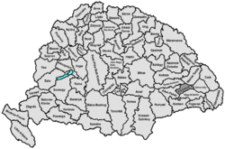
Klein-Kokelburg County
|
Klein-Kokelburg County (Kis-Küküllő) (1910) |
|
|---|---|

|
|
| Administrative headquarters : | Dicsőszentmárton |
| Area : | 1,724 km² |
| Population : | 116.091 |
| Ethnic groups : | 48% Romanians 30% Hungarians 17.5% Germans 4.5% others |

|
|
The Kis-Küküllő County (German and County Small Kokel or rarely County Kleinkokeln ; Hungarian Kis-Küküllő vármegye , Romanian Comitatul Târnava-Mică ) was an administrative unit ( county , county ) of the Kingdom of Hungary . Today the area is in Transylvania in Romania .
Location and general
It bordered on the counties of Torda-Aranyos , Maros-Torda , Udvarhely , Groß-Kokelburg (Nagy-Küküllő) and Unterweißburg (Alsó-Fehér) .
The German name Kokelburg is derived from the Kokelburg Castle (today Cetatea de Baltă ), which was the administrative center of the predecessor Comitat in the Middle Ages. However, it is named after the Kleine Kokel river flowing through the county .
geography
The entire county is very hilly due to its location in the south of the Transylvanian Basin and is traversed by the eponymous river Kleine Kokel (today Romanian Târnava Mică ) and on the southern border by the river Grosse Kokel (today Romanian Târnava Mare ). Due to the mild climate there was a flourishing agriculture in the county; Trade and handicrafts were also well developed.
history
Klein-Kokelburg County was established in 1876 when the Kokelburg County ( Küküllő vármegye in Hungarian ), which previously existed in the Grand Duchy of Transylvania , was dissolved together with the neighboring Saxon chairs of Mediasch , Schäßburg and Hermannstadt and divided into the Klein- and Groß-Kokelburg counties. The administrative seat was initially Erzsébetváros (now Romanian Dumbrăveni ), later it became Dicsőszentmárton (now Romanian Târnăveni ).
After the end of the First World War in 1918, the area came to Greater Romania as a result of the Treaty of Trianon and initially continued to exist here as a Județ (district) Târnava-Mică. In 1950 an administrative reform took place in which the district became part of the Brașov region. After the return to the Județe principle, the territory of the former county was divided up, with the area around Târnăveni being assigned to Mureş County , the southwest to Alba County and the area around Dumbrăveni to Sibiu County .
District subdivision
In the early 20th century, the county consisted of the following chair districts (named after the name of the administrative center):
| Chair districts (járások) | |
|---|---|
| Chair district | Administrative headquarters |
| Dicsőszentmárton | Dicsőszentmárton, today Târnăveni |
| Erzsébetváros | Erzsébetváros, today Dumbrăveni |
| Hosszúaszó | Hosszúaszó, today Valea Lungă |
| Radnót | Radnót, today Iernut |
| City districts (rendezett tanácsú városok) | |
| Dicsőszentmárton, today Târnăveni | |
| Erzsébetváros, today Dumbrăveni | |
All places are in today's Romania .
See also
Web links
- Entry on the county in Meyers Konversationslexikon from 1888
- Entry in the Pallas Lexicon (Hungarian)
swell
- ↑ A magyar szent corona országainak 1910. évi népszámlálása . Budapest 1912, p. 12 ff.
- ↑ A magyar szent corona országainak 1910. évi népszámlálása . Budapest 1912, p. 22 ff. (1910 census)


