
Iernut
|
Iernut Radnuten Radnót |
|||||
|
|||||
| Basic data | |||||
|---|---|---|---|---|---|
| State : |
|
||||
| Historical region : | Transylvania | ||||
| Circle : | Mureș | ||||
| Coordinates : | 46 ° 27 ' N , 24 ° 14' E | ||||
| Time zone : | EET ( UTC +2) | ||||
| Height : | 276 m | ||||
| Area : | 106.36 km² | ||||
| Residents : | 8,705 (October 20, 2011) | ||||
| Population density : | 82 inhabitants per km² | ||||
| Postal code : | 545100 | ||||
| Telephone code : | (+40) 02 65 | ||||
| License plate : | MS | ||||
| Structure and administration (as of 2016) | |||||
| Community type : | city | ||||
| Structure : | 8 districts / cadastral communities: Cipău , Deag , Lechința , Oarba de Mureș , Porumbac , Racameț , Sălcud , Sfântu Gheorghe | ||||
| Mayor : | Ioan Nicoară ( PNL ) | ||||
| Postal address : | Str. 1 Decembrie 1918, no. 9 loc. Iernut, jud. Mureș, RO-545100 |
||||


Iernut ( German Radnuten , Hungarian Radnót ) is a small town in the Mureș County in Romania .
location
Iernut is located approximately in the middle of Transylvania , on the left bank of the river Mures ( Mures ). The district capital Târgu Mureș is located about 25 km northeast.
history
Archaeological finds in the area of Iernut, called Fundu Bedeelor by the locals , prove that the region has been settled since the Bronze Age . A Roman colony existed on the territory of today's city in the 2nd and 3rd centuries .
Iernut was first mentioned in a document in 1257 under the name terra Ranolth ; at that time it belonged to the Kingdom of Hungary , later to the Principality of Transylvania and Austria-Hungary . In 1461 the place was raised to the market ( oppidum Radnot ). The place was the center of a feudal rule that was successively owned by different Hungarian noble families (including Bethlen and Rákoczi ). The Romanian name has been documented in writing since 1854. In September 1944 - during the Second World War - there was fierce fighting between German troops on the one hand and Soviet and Romanian units on the other in what is now the Oarba de Mureș district . In socialist Romania, several industrial companies were established, including a thermal power station . In 1989 Iernut was named a city.
In addition to energy production, important industries are agriculture, food processing and fish farming.
population
At the 1850 census, of the 5268 inhabitants in the area of today's city, 4113 were Romanians , 851 Hungarians and 292 Roma . Up to 1966 there was a significant increase in population (11,635); thereafter the population decreased. In 2002, 9,523 people were registered in the city, including 7229 Romanians, 1426 Hungarians, 852 Roma and 12 Germans . 5830 lived in the actual city, 3693 in the eight incorporated villages.
traffic
Iernut is on the Alba Iulia – Târgu Mureș railway line . Around eight local trains run in both directions every day. There are regular bus connections to Luduş and Târgu Mureş. The European route 60 runs through Iernut .
Attractions
- Kornis-Rákoczi-Bethlen Castle (1545, rebuilt 1650–1660) in Renaissance style, is a listed building.
- Reformed church built in the 15th century, renovated in the 19th century, is a listed building.
- Orthodox Church (18th century)
- historical Museum
- Memorial to the fighting in 1944 in the district of Oarba de Mureș
- Wooden church built in the Deag district in 1765, is a listed building.

Kornis-Rákoczi-Bethlen Castle

Wooden church in Sfântu Gheorghe
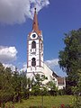
Reformed Church in Iernut
.JPG)
.JPG)

Web links
Individual evidence
- ↑ 2011 census in Romania at citypopulation.de
- ↑ a b c d List of historical monuments of the Romanian Ministry of Culture, updated 2010 (PDF; 7.10 MB)
- ↑ Mureş County website, accessed February 1, 2009
- ↑ 2002 census, accessed on February 1, 2009 (PDF; 1.2 MB)
Iernut | Luduș | Miercurea Nirajului | Reghin | Sângeorgiu de Pădure | Sărmașu | Sighișoara | Sovata | Târgu Mureș | Târnăveni | Ungheni