Miercurea Nirajului
|
Miercurea Nirajului Sereda Nyárádszereda |
||||
|
||||
| Basic data | ||||
|---|---|---|---|---|
| State : |
|
|||
| Historical region : | Transylvania | |||
| Circle : | Mureș | |||
| Coordinates : | 46 ° 32 ' N , 24 ° 48' E | |||
| Time zone : | EET ( UTC +2) | |||
| Height : | 350 m | |||
| Area : | 55.88 km² | |||
| Residents : | 5,554 (October 20, 2011) | |||
| Population density : | 99 inhabitants per km² | |||
| Postal code : | 547410 | |||
| Telephone code : | (+40) 02 65 | |||
| License plate : | MS | |||
| Structure and administration (as of 2016) | ||||
| Community type : | city | |||
| Structure : | 7 districts / cadastral communities: Beu , Dumitreşti , Lăureni , Moşuni , Șardu-Nirajului , Tâmpa , Veta | |||
| Mayor : | Sándor Tóth ( UDMR ) | |||
| Postal address : | Piața Teilor, no. 48 loc. Miercurea Nirajului, jud. Mureș, RO-547410 |
|||
| Website : | ||||
Miercurea Nirajului ( German Sereda , Hungarian Nyárádszereda ) is a city in the Mureș County in Romania .
location
Miercurea Nirajului is located roughly in the middle of Transylvania on the Niraj River . The district capital Târgu Mureş is located about 20 km to the west.
history
Archaeological excavations show that the region has been settled since the Neolithic ; stone axes from the period between 2000 and 1700 BC were found. BC, coins from the time of the Byzantine emperor Justinian I found in the incorporated town of Lăureni .
The first documentary mention was made in 1493 under the name Zereda. This is of Slavic origin and means roughly “middle”, “market place” or “Wednesday” as the weekday. The Romanian name "Miercurea" is derived from the latter; "Nirajului" is the adjective of the river on which the place is located.
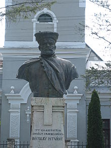
From 1600 to 1603 the troops of the imperial Habsburg general Giorgio Basta devastated the area around the village. On February 21, 1605, Miercurea Nirajului experienced the historically most important moment in its history, when the Transylvanian estates elected Stephan Bocskai as their prince.
For a long time Miercurea Nirajului was the seat of the Szekler chair Marosszék before Târgu Mureș took over this function in the 18th century. After that, Miercurea Nirajului largely lost its former importance and became an ordinary village.
After the revolution of 1848 the place took off again. As a result of the First World War , Miercurea Nirajului - which like the rest of Transylvania had previously belonged to the Kingdom of Hungary , the Principality of Transylvania and Austria-Hungary - came to Romania. As a result of the Second Vienna Arbitration , the place, which then as now had a Hungarian majority, became part of Hungary again from 1940 to 1944.
After the First World War and increasingly after the Second World War , industrial development began; apartment blocks were built in the 1970s and 1980s.
In 2003 Miercurea Nirajului was declared a city.
The most important branches of industry are agriculture and wood processing.
population
In the 1850 census, of the 3003 inhabitants in the area of today's city, 1637 were Hungarians , 1056 Romanians and 303 Roma . 386 of them lived in Miercurea Nirajului in the narrower sense, the rest in the villages that are incorporated today. In 2002, 5824 people were registered in the municipality, including 4890 Hungarians, 620 Romanians and 312 Roma. 3806 lived in the actual city, in 2018 in the seven incorporated villages.
traffic
Miercurea Nirajului is located on the disused small railway line from Târgu Mureș to Sovata . There are regular bus connections to Târgu Mureș .
Attractions
- Reformed church (15th century) with wooden bell tower (18th century)
- Wooden Gate (1723)
- Catholic church (18th century) in the Beu district
- Reformed church (1780) in the Moșuni district
- Greek Catholic wooden church (1843)
- Bust of Stephan Bocskai (1906)
Born in Miercurea Nirajului
- Zoltan Lunka (* 1970), professional boxer
Web links
Individual evidence
- ↑ 2011 census in Romania at citypopulation.de
- ↑ Mureş County Council's website, accessed on May 1, 2009
- ↑ 2002 census, accessed on May 1, 2009 (PDF; 1.2 MB)


