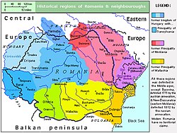
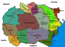
List of historical regions in Romania and the Republic of Moldova
The following historical regions are located in Romania and the Republic of Moldova :
Banat
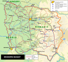
| The Banat covers an area of 28,523 square kilometers. Most of the Banat lies in the Timiș and Caraș-Severin counties in Romania. The Romanian Banat consists in the west of a part of the Pannonian lowlands ("the heath"), in the northeast of the hill country ("the hedge") and in the southeast of the Carpathians ( Banater Mountains , Poiana-Ruscă and Retezat Mountains ). The economic and cultural center is the city of Timișoara (German Timişoara or Temeschburg , Hungarian Temesvár ). The western part of the Banat lies in Serbia and consists almost entirely of flat land , except for the Vršačke Planine mountain range . The north-westernmost tip of the Banat lies in the south-east of Hungary .
Today the Banat is divided into the following groups;
in Serbia:
in Hungary: |
Dobruja
| The Dobrudscha ( Romanian Dobrogea , Bulgarian Добруджа
Dobrudža , Turkish Dobruca ; also Trans- Danubia ) is a landscape between the lower reaches of the Danube and the Black Sea . The landscape forms the border area between south-east Romania and north-east Bulgaria.
The Dobruja is the northeastern tip of the Balkan Peninsula and covers an area of 23,262 square kilometers. The Romanian area ratio in the circles Tulcea and Constanţa is 15,570 square kilometers. The Dobrudscha is 467 meters high in the iatu ( uiatul ( Greci ) in the northwest; south of the Cernavodă-Constanța depression, it is a loess-covered, fertile steppe table that rises up to 200 meters high. The biggest cities are Constanța and Tulcea (in Romania) and Dobrich and Silistra (in Bulgaria). |
Screeching area
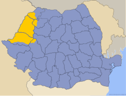
| The Kreischgebiet (also Kreischland , Romanian Crișana , Hungarian Körösvidék ) is a historical landscape with the smaller part in the east of Hungary in the Hajdú-Bihar and Békés counties and the larger part in the north-west of Romania in the Bihor and Arad counties . Its area borders in the south on the river Mieresch (also Marosch ), in the east on the Apuseni Mountains and in the west on the Tisza . |
Maramureș
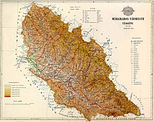
| Máramaros County (German also Maramuresch or Marmarosch County ; Hungarian Máramaros vármegye or older Mármaros , Latin comitatus Maramarosiensis ) was an administrative unit (county) in the Kingdom of Hungary . The county bordered in the north and northeast on the Austrian Duchy of Galicia (or before 1772 on Poland ), on a small piece in the east on the Austrian crown land Bukowina in the east south on the county Bistritz-Naszod (Beszterce-Naszód) , in the south the Szolnok-Doboka County , on the southwest by the County Satu Mare (Szatmár) and the small Ugocsa County and the west by the Bereg County . It lay between the mountain range of the Carpathians in the north and on both sides of the Tisza and in 1910 had an area of 9,716 km².
Today the northern part is in western Ukraine (in the Transcarpathian Oblast , see also Carpathian Ukraine ), and the southern part in northwestern Romania in the Maramureș district . |
Moldova
| The former principality consisted of the western part - today in Romania - and the eastern part - today in the Republic of Moldova, the northern and south-eastern parts are now in Ukraine . A small part of Moldavia region (as opposed to " eastern Moldavia " also West of Moldova called), bordered to the north Bukovina and in the east with the river Prut in Bessarabia . The Herza area (Romanian: Ținutul Herța, Ukrainian: Край Герца) has been in Ukraine since 1944, over 90% of the population are ethnically Romanian. The northern part of Bukowina (German Buchenland ) is in Ukraine. In the west the Carpathian Mountains form the border with Transylvania, in the south the Milcov and Siret rivers form the border with Wallachia. The for UNESCO - World Heritage Site belonging Moldavian monasteries are mainly located in the historic center of power of the former Principality of Moldavia in the counties of Suceava and Neamt.
West Moldova was the northern part of the Romanian Old Kingdom and comprised the former districts of Dorohoi (including the Herza area ), Botoșani, Suceava (later: Fălticeni), Neamț, Iași, Roman, Vaslui, Fălciu, Bacău, Tecuci, Tutova, Vrancea and Covurlui. The area of this region extends to 38,224 km². |
Sathmar
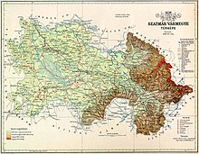
| The Satu Mare County (Hungarian vármegye Szatmár ; Latin comitatus Szathmariensis ) was an administrative unit (County / County) in the Kingdom of Hungary . Today the smaller part of Sathmar (about 1/4 of the area) is in northeastern Hungary in Szabolcs-Szatmár-Bereg County . The larger part with about three quarters of the area is located in northwest Romania mainly in today's Satu Mare district , but also includes parts of Maramureș district. A small part of the region is located around the town of Welyka Palad (then Nagypalád in Hungarian ) and is now part of the Ukrainian Zakarpattia Oblast . In 1910 it had an area of 6,287 km². |
Transylvania
Transylvania is known by the following names:
- The Romanian name is Ardeal or Transilvania ;
- The Hungarian name is Erdély or erdő-elve ;
- The Latin name is Transsilvania derived from trans silvana (= beyond the woods);
- The term Transylvania or Transylvania, which was Germanized on this basis, was used in medieval documents.
The origin of the German name Siebenbürgen has not been conclusively clarified. It is assumed that it can be traced back to the seven cities founded by German settlers (the Transylvanian Saxons ) ( Kronstadt , Schäßburg , Mediasch , Hermannstadt , Mühlbach , Bistritz and Klausenburg ). The associated chairs (Hungarian szék , units of their own jurisdiction - each chair had a royal judge who was solely subordinate to the Hungarian king ) may be part of the naming. The name is initially recorded in German sources from the 13th century as Septum urbium, Terra septem castrorum and similar variants. In German records it is called Siebenbuergen for the first time at the end of the 13th century and at that time only referred to the area of the seven chairs as administrative units or regional authorities of the Sibiu province. Only later did the term expand spatially and finally encompass the same space as Ardeal and Erdély .
Geographically, Transylvania forms the center and north-west of Romania. Transylvania is separated from the southern ( Wallachia ) and eastern ( Moldau and Bukovina ) parts of the country by the Eastern Carpathians and the Transylvanian Alps (Southern Carpathians), which together form the southern Carpathian arch . To the west, part of the Western Romanian Carpathians , the Apuseni Mountains , separates Transylvania from the Kreisch area . The area of Transylvania is 59,651 km².
Also part of today's Romania, which until 1918/1920 to Hungary belonged (the Crisana, the region Satu Mare, the southern part of the former county of Maramures and the Romanian part of Banat) are sometimes erroneously Transilvania added, so that there is often greater than the historical area is represented.
Wallachia
|
The Walachia region is made up of Little Wallachia (Oltenia, Romanian Oltenia ) in the west and Great Wallachia (Muntenia, Romanian Muntenia ) in the east. |
