
Poiana Ruscă Mountains
| Poiana Ruscă Mountains | |
|---|---|
 The Poiana Ruscă Mountains (2) |
|
 Poiana Ruscă Mountains |
|
| Highest peak | Padeș ( 1374 m ) |
| location | Romania |
| Part of the Western Romanian Carpathians | Carpathians |
| Coordinates | 45 ° 55 ' N , 22 ° 3' E |


The Poiana Ruscă Mountains ( Romanian Munții Poiana Ruscă ) is a mountain range of the western Romanian Carpathians that connects the Apuseni Mountains in the north and the Banat Mountains in the south. The Poiana Ruscă Mountains cover an area of around 2,640 square kilometers at an average altitude of 700 to 1000 meters.
Geographical location
In the north, the Poiana-Ruscă Mountains border the Transylvanian Ore Mountains , the southernmost part of the Apuseni Mountains, and the Lipova hills (Romanian: Dealurile Lipovei ), with the northern border between Deva and Dobra being marked by the course of the Marosch .
In the west, the mountain range is bounded by the Caransebeşer depression and between Maciova and Coştei by the Temesch .
The course of the Bistra separates the Poiana-Ruscă Mountains in north-south direction from the Țarcu Mountains .
In the east, the mountain range along the cities of Hațeg , Hunedoara and Deva is bounded by the Hațeger and Streisenke basins .
description
The Poiana-Ruscă Mountains extend over the Karasch-Severin , Timiș and Hunedoara districts . The highest peaks are the Padeş (1,374 meters), the Rusca (1,355 meters) and the Poiana (1,049 meters) peaks. From a geological point of view, the mountain range consists of crystalline slate , limestone and sandstone . The marble in the Poiana Ruscă Mountains can compete with the Carrara marble. In Rușchița is one of the largest and oldest centers for the extraction of marble. The mountains are also rich in lead , zinc , copper and gold .
Before the Second World War, there was a well-developed tourism in the Poiana-Ruscă Mountains. In 1937, at the place "Șapte izvoare" (German: Seven Sources ) by the "Clubul Turistic Bănățean" (German: Banater Tourismus-Klub ), a "monument of tourism" was erected at a height of 800 meters from local marble. Every year in August the "Day of the Tourism Monument" is celebrated here.
Hydrography
- The Marosch hydrographic basin covers an area of 1,452 square kilometers and collects the waters in the east of the Poiana-Ruscă Mountains, of which the Cerna , the Strei and the Dobra are the most important. In 1962 the Cinciș dam was built on the Cerna. The former village of Cinciș was flooded. When the water level is low, the top of the steeple, the church built in 1360, protrudes from the reservoir.
- The Bega is a catchment basin for the waters in the northwest of the Poiana-Ruscă Mountains, whereby the tributaries Bega Poienilor , Bega Luncanilor , Gladna and Sarazul are of the greatest importance.
- The Bistra is a reservoir for the rivers south of the Padeș and Rusca peaks. Its main tributary is the Rusca . It collects the waters of the Rivers Pârâul cu Raci , Valea Morii , Miclăuș , Șoimul and Lozna .
- The Nădrag is the most important river in the west of the Poiana-Ruscă Mountains. It arises from the confluence of the Cornetu with the Padeș , which unite at the level of the municipality of Nădrag and then turn to the Temesch .
caves
There are some caves in the Poiana Ruscă Mountains:
- Peştera Româneşti : This is where the concert of the Banat Philharmonic from Timişoara takes place every year.
- Peştera Spurcată de la Nandru
- Peştera no.1 de la Cerişor
- Peştera Bulgărelu de la Ciulpăz
- Peştera Piatra Fetii de la Ruşchița
flora

Beech forest

Spruce

Hornbeam


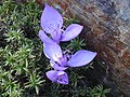
Banat autumn crocus

Bristle grass willow


The vegetation of the Poiana-Ruscă Mountains consists largely of forests. Extensive meadows can be found on the high plateau.
Forests :
- Beeches ( Fagus silvatica )
- Fir trees ( Abies alba )
- Spruce trees ( Picea abies )
- European beech ( Fagus sylvatica )
- Hornbeam ( Carpinus betulus )
- Silver birch trees ( Betula pendula )
Grasses :
- Common red fescue ( Festuca rubra )
- Bristle grass ( Nardus stricta )
Berries :
- Forest strawberry ( Fragaria vesca )
- Raspberry ( Rubus idaeus )
- Blackberries ( Rubus hirtus )
- Heather family ( Bruckenthalia spiculifolia )
- Blueberry ( Vaccinium myrtillus )
- Common lilac (Syringa vulgaris)
- Banat autumn crocus ( Crocus banaticus )
fauna

brown bear

wild boar

wolf


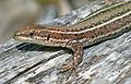
lizard
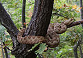
Horned viper


The Poiana Ruscă Mountains are home to a rich fauna that can vary depending on the vegetation and altitude zone .
- Brown bear ( Ursus arctos )
- Wild boar ( Sus scrofa )
- Eurasian lynx ( Lynx lynx )
- Wolf ( Canis lupus )
- Red fox ( Vulpes vulpes )
Rodents :
- Hares (Leporidae)
- Red squirrel ( Sciurus vulgaris )
Reptiles :
- Real lizards (Lacertidae)
- salamander
Snakes :
- Adder ( Vipera berus )
- European horned viper ( Vipera ammodytes )
Fish :
- Brown trout ( Salmo trutta fario )
- European grayling ( Thymallus thymallus )
- Chub ( Leuciscus cephalus )
literature
- Franz Engelmann: The Poiana Rusca . In: Komm mit '83, pp. 49–56 . Verlag Neuer Weg, Bucureşti 1983. Online at karpatenwanderer.de
- Hans-Georg Kräutner: Munţii Poiana Ruscă . Munţii noştri No. 30. Ghid turistic, Bucureşti 1984. Online at rennkuckuck.de (in Romanian, 154 pages, 11 maps, 2 views + map supplement )