
Dobra (Hunedoara)
|
Dobra Hunyaddobra |
|||||
|
|||||
| Basic data | |||||
|---|---|---|---|---|---|
| State : |
|
||||
| Historical region : | Transylvania | ||||
| Circle : | Hunedoara | ||||
| Coordinates : | 45 ° 55 ' N , 22 ° 34' E | ||||
| Time zone : | EET ( UTC +2) | ||||
| Height : | 200 m | ||||
| Area : | 138.16 km² | ||||
| Residents : | 3,345 (October 20, 2011) | ||||
| Population density : | 24 inhabitants per km² | ||||
| Postal code : | 337215 | ||||
| Telephone code : | (+40) 02 54 | ||||
| License plate : | HD | ||||
| Structure and administration (as of 2016) | |||||
| Community type : | local community | ||||
| Structure : | Dobra, Abucea , Bujoru , Făgețel , Lăpuşnic , Mihăieşti , Panc , Panc-Sălişte , Răduleşti , Roşcani , Stânceşti , Stânceşti-Ohaba , Stretea | ||||
| Mayor : | Ovidiu-Iosif Pădurean ( PSD ) | ||||
| Postal address : | P-ța Victorie, no. 1 loc. Dobra, jud. Hunedoara, RO-337215 |
||||


Dobra ( Hungarian Hunyaddobra ) is a municipality in the Hunedoara district in Transylvania , Romania .
The place is also known by the Hungarian names Dobra and Jófő .
Geographical location

Dobra is a municipality in southwest Transylvania, north of the Poiana-Ruscă Mountains - a mountain range of the Romanian Western Carpathians - on the stream of the same name, a left tributary of the Mureș ( Mieresch ). In the Miereschtal, in the west of the Hunedoara district, the place is located on the European route 673 and the Ilia-Lugoj railway line about 30 kilometers west of the district capital Deva ( Diemrich ).
The Romanian A1 motorway should (when finished) also run on the site of the village.
history
Dobra was first mentioned in a document in 1387 and was a Romanian district in the historic Hunyad County ( Eisenmarkt County ) in the Middle Ages . Settlement of the region goes back much further, however. In a report by D. Berciu , a settlement on the area of the place, which points to early history , was recorded. According to reports by G. Téglás , I. Marțian and M. Roska , bronze parts from the Late Bronze Age were found. Along the Mureș, on the area of today's municipality, the course of a Roman road is also recorded.
population
The population of the municipality developed as follows:
| census | Ethnic composition | |||||||
|---|---|---|---|---|---|---|---|---|
| year | population | Romanians | Hungary | German | other | |||
| 1850 | 5.114 | 4,844 | 105 | 44 | 121 | |||
| 1890 | 5,252 | 4,974 | 141 | 114 | 23 | |||
| 1930 | 5,636 | 5,253 | 139 | 43 | 201 | |||
| 1977 | 4,588 | 4,514 | 47 | 4th | 23 | |||
| 2002 | 3,499 | 3,454 | 24 | 1 | 20th | |||
Since the official census of 1850, mostly Romanians have been registered in the area of today's municipality . The highest population (6,261) - at the same time that of the Romanians (5,637) and the Magyars (450) - was determined in 1910. The highest population of Roma (146) was registered in 1930 and that of Romanian Germans in 1890. Furthermore, Slovaks (highest population 61; 1900), Serbs (highest population 29; 1880) and Ukrainians (highest population 4; 1992) were also registered in almost every survey in the municipality of Dobra . At the October 31, 2011 census, 1,501 households in the municipality counted 3,242 people.
The main occupation of the population is the forestry and timber industry and work in gravel mining on the Mureș.
Attractions
- The former mayor's office in Dobra, built in the 19th century, is a listed building.
- The wooden churches Cuvioasa Paraschiva , in the incorporated village of Răduleşti , built in 1733; in the incorporated village of Abucea , built in the 18th century; in the incorporated village of Stânceşti , built in the 19th century, are under monument protection.
- The church Cuvioasa Paraschiva , in the incorporated village of Lăpuşnic , in the 17th century and the church Buna Vestire , in the incorporated village of Roşcani , built in the 18th century, are listed monuments.

Former village center Dobras (with Hotel Zum Husaren )

Ruins of the former mayor's office in Dobra

Mayor's office in Dobra

View of Dobra
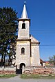
Orthodox Church in Dobra
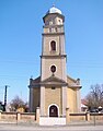
Roman Catholic Church in Dobra

Church in Panc-Sălişte

Wooden church in Răduleşti

Wooden church in Stânceşti

.JPG)
.JPG)
.JPG)
.JPG)
.JPG)
.JPG)

Web links
Individual evidence
- ↑ 2011 census in Romania at citypopulation.de
- ^ Dictionary of the localities in Transylvania
- ↑ Heinz Heltmann, Gustav Servatius (Ed.): Travel Guide Siebenbürgen. Kraft, Würzburg 1993, ISBN 3-8083-2019-2 .
- ^ Institute Of Archeology - Dobra, accessed March 16, 2013 (Romanian)
- ↑ Census, last updated November 2, 2008, p. 90 (Hungarian; PDF; 1.1 MB)
- ^ Result of the preliminary census on October 31, 2011 at antena3.ro (Romanian; PDF; 172 kB)
- ↑ a b c List of historical monuments of the Romanian Ministry of Culture, updated 2010 (PDF; 7.10 MB)
- ↑ Information on the church in Răduleşti from biserici.org accessed on March 16, 2013 (Romanian)
- ↑ Information on the wooden church in Abucea from biserici.org accessed on March 16, 2013 (Romanian)
- ↑ Information on the church in Stânceşti from biserici.org accessed on March 17, 2013 (Romanian)
- ↑ Information on the church in Lăpușnic from biserici.org accessed on March 17, 2013 (Romanian)
- ↑ Information on the church in Roșcani from biserici.org accessed on March 17, 2013 (Romanian)
Băcia | Baia de Criș | Băița | Balșa | Bănița | Baru | Bătrâna | Beriu | Blăjeni | Boșorod | Brănișca | Bretea Română | Buceș | Bucureșci | Bulzeștii de Sus | Bunila | Burjuc | Cârjiți | Cerbăl | Certeju de Sus | Crișcior | Densuș | Dobra | General Berthelot | Ghelari | Gurasada | Hărău | Ilia | Lăpugiu de Jos | Read | Lunca Cernii de Jos | Luncoiu de Jos | Mărtineşti | Orăştioara de Sus | Pestișu Mic | Pui | Răchitova | Rapoltu Mare | Râu de Mori | Ribița | Romos | Sălașu de Sus | Sântămăria-Orlea | Sarmizegetusa | Șoimuș | Teliucu Inferior | Tomeşti | Toplița | Totești | Turdaș | Vălișoara | Vața de Jos | Vețel | Vorța | Zam