
Orăştioara de Sus
|
Orăștioara de Sus Ober-Brooserbach Felsővárosviz |
|||||
|
|||||
| Basic data | |||||
|---|---|---|---|---|---|
| State : |
|
||||
| Historical region : | Transylvania | ||||
| Circle : | Hunedoara | ||||
| Coordinates : | 45 ° 44 ' N , 23 ° 10' E | ||||
| Time zone : | EET ( UTC +2) | ||||
| Height : | 322 m | ||||
| Area : | 229.30 km² | ||||
| Residents : | 2,079 (October 20, 2011) | ||||
| Population density : | 9 inhabitants per km² | ||||
| Postal code : | 337325 | ||||
| Telephone code : | (+40) 02 54 | ||||
| License plate : | HD | ||||
| Structure and administration (as of 2016) | |||||
| Community type : | local community | ||||
| Structure : | Orăştioara de Sus, Bucium , Costeşti , Costeşti-Deal , Grădiştea de Munte , Ludeştii de Jos , Ludeştii de Sus , Ocolişu Mic | ||||
| Mayor : | Vasile-Marian Inășescu ( PNL ) | ||||
| Postal address : | Str. Principală, no. 133 loc. Orăştioara de Sus, jud. Hunedoara, RO-337325 |
||||
| Website : | |||||


Orăştioara de Sus [ ˈorɘʃtioara de sus ] ( German Ober-Brooserbach , Hungarian Felsővárosviz ) is a municipality in the Hunedoara district in Transylvania , Romania .
The place is also known by the Hungarian names Felsővárosvize , Városviz and Városvize .
Geographical location

The municipality of Orăştioara de Sus is located with its eight villages and scattered settlements in the southwest of the Transylvanian Basin, northwest of the Șureanu Mountains ( Mühlbacher Mountains ), in the historical region of Hunyad County ( Eisenmarkt County ) in the Szászváros chair district . At Orăştie - a left tributary of the Mureş ( Mieresch ) - and the county road ( Drum județean ) DJ 705A, the place is about 15 kilometers south of the small town of Orăştie ( Broos ); the district capital Deva ( Diemrich ) is located about 45 kilometers northwest of Orăştioara de Sus.
history
The place Orăştioara de Sus was first mentioned in 1455. However, the history of the settlement goes back to the Latène period . According to reports by G. Téglás and M. Roska , Dacian jewels were found during archaeological excavations on the site .
The region of the municipality is also known for the ruins of several Dacian sanctuaries, living quarters and fortifications, which were added to the list of UNESCO World Heritage Sites in 1999 .
The main occupations of the population are cattle breeding , agriculture and forestry .
population
In 1850, 2955 inhabitants lived in the area of the municipality. 2833 of them were Romanians , 113 Roma , five Hungarians and four others. The largest population of the municipality (3629) - and at the same time that of the Romanians (3558) - was determined in 1910. The highest number of Roma (140) and that of Hungarians (32) was registered in 1956, that of Romanian Germans (19) in 1900. In addition, some residents referred to themselves as Ukrainians at almost every recording ; the highest number (47) was registered in 1966. In 1900 one resident and in 1966 seven residents referred to themselves as Slovaks .
Attractions
- Sarmizegetusa Regia , on the area of the incorporated village of Grădiştea de Munte (ung. Gredistye ). For over 20 years, the Ministry of Culture, the Environment and the Ministry of the Interior, representatives of the Hunedoara district and representatives of the Orăștioara de Sus municipality have not been able to agree on who is responsible for the maintenance of the historical complex. The failed URBANPROIEC - founded in 2000 - was defined in a regional project ( Programul Operulional Regional 2007–2013)in 2007; this was only presented for approval in 2010.
- The ruins the Dacian forts Blidaru ( 45 ° 40 ' N , 23 ° 10' O ) and Cetatuie ( 45 ° 41 ' N , 23 ° 9' O ), on the site of unincorporated village Costeşti (ung. Kosztesd ) are listed .
- The ruins of Roman fortresses on the area of the incorporated villages of Bucium (" Piatra Grădiștii "), Costești (" Grădiște ", 405 m ), Costești-Deal (" Prisaca ", 1219 m ), Grădiștea de Munte (" Dealul Grădiștii ", approx . 1000 m ) are under monument protection.
- The nature reserve Grădiştea Munceului-Cioclovina , about 380 km² in size, with the caves Cioclovina Uscată , Cioclovina cu Apă u. a.

Sarmizegetusa Regia

Remains of the Costeşti Castle
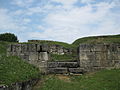
Remains of the Blidaru Castle


Personalities
- Ion R. Baciu (1921–2004), was a doctor and pathophysiologist ; 1993 member of the Romanian Academy ; 1994 honorary citizen of the city of Cluj-Napoca ( Klausenburg ), 1996 of Orăştioara de Sus and 2004 of Orăştie ( Broos ).
Web links
Individual evidence
- ↑ 2011 census in Romania at citypopulation.de
- ↑ a b Heinz Heltmann, Gustav Servatius (Ed.): Travel Guide Siebenbürgen. Kraft, Würzburg 1993, ISBN 3-8083-2019-2 .
- ^ Dictionary of the localities in Transylvania
- ^ Institute Of Archeology - Orăștioara de Sus, accessed May 31, 2011 (Romanian)
- ↑ Entry UNESCO World Heritage
- ↑ Census, last updated November 4, 2008, p. 117 (Hungarian; PDF; 1.1 MB)
- ↑ Ciprian Iancu: Law for Sarmizegetusa of March 11, 2010 in "Evenimentul Zilei.ro" accessed on June 2, 2011 (Romanian)
- ↑ Page no longer available , search in web archives: Tourist paths built only after Mircea Moloț - the district chairman of Hunedoara - was able to build paths to his property with European means in Afaceri in Valea Jiului.ro, accessed on April 15, 2011 on June 2, 2011 (Romanian)
- ↑ a b List of historical monuments of the Romanian Ministry of Culture, updated 2010 (PDF; 7.10 MB)
- ↑ Description of the Grădiștea Munceului-Cioclovina reserve (Romanian)
- ↑ Rules of the Grădiștea Munceului-Cioclovina Reserve (Romanian)
- ↑ Ion Baciu ( Memento of December 2, 2010 in the Internet Archive ) at the American Physiological Society , accessed on May 31, 2011 (English)
- ^ Ion R. Baciu at the Romanian Academy, accessed May 31, 2011
- ↑ Honorary Citizen of Cluj-Napoca, accessed May 31, 2011
- ↑ Ioan Baciu on the web presentation of the honorary citizens of Orăștie, accessed on June 2, 2011 (Romanian)
Băcia | Baia de Criș | Băița | Balșa | Bănița | Baru | Bătrâna | Beriu | Blăjeni | Boșorod | Brănișca | Bretea Română | Buceș | Bucureșci | Bulzeștii de Sus | Bunila | Burjuc | Cârjiți | Cerbăl | Certeju de Sus | Crișcior | Densuș | Dobra | General Berthelot | Ghelari | Gurasada | Hărău | Ilia | Lăpugiu de Jos | Read | Lunca Cernii de Jos | Luncoiu de Jos | Mărtineşti | Orăştioara de Sus | Pestișu Mic | Pui | Răchitova | Rapoltu Mare | Râu de Mori | Ribița | Romos | Sălașu de Sus | Sântămăria-Orlea | Sarmizegetusa | Șoimuș | Teliucu Inferior | Tomeşti | Toplița | Totești | Turdaș | Vălișoara | Vața de Jos | Vețel | Vorța | Zam