
Băcia
|
Băcia Shepherd Village Bácsi |
|||||
|
|||||
| Basic data | |||||
|---|---|---|---|---|---|
| State : |
|
||||
| Historical region : | Transylvania | ||||
| Circle : | Hunedoara | ||||
| Coordinates : | 45 ° 48 ' N , 23 ° 0' E | ||||
| Time zone : | EET ( UTC +2) | ||||
| Height : | 211 m | ||||
| Area : | 29.73 km² | ||||
| Residents : | 1,827 (October 20, 2011) | ||||
| Population density : | 61 inhabitants per km² | ||||
| Postal code : | 337040 | ||||
| Telephone code : | (+40) 02 54 | ||||
| License plate : | HD | ||||
| Structure and administration (as of 2016) | |||||
| Community type : | local community | ||||
| Structure : | Băcia, Petreni , Tâmpa , Totia | ||||
| Mayor : | Florin Alba ( PSD ) | ||||
| Postal address : | Str. Principală, no. 242 loc. Băcia, jud. Hunedoara, RO-337040 |
||||
| Website : | |||||


Băcia [ bˈɘcia ] ( German shepherd village , Hungarian Bácsi or Alsóbácsi ) is a municipality in the Hunedoara district in Transylvania , Romania .
Geographical location

The municipality of Băcia is located in the center of the Hunedoara district, in a left side valley of the Mureș ( Mieresch ) on the Strei ( Strell ) river. Located on the Simeria – Petroșani railway line , European route 79 and the county road ( drum județean ) DJ 668D, the place is about 5 kilometers north of the small town of Călan ( Klandorf ); the district capital Deva ( Diemrich ) is located about 18 kilometers northwest of Băcia.
history
The place, which was Hungarian in the Middle Ages , was first mentioned in a document in 1332. In the 17th - 18th centuries, reformed Hungarians lived in what is now Băcia; Romanian farmers also settled in this period. However, the history of settlement in the region - according to reports by G. Téglás - goes back to Roman times . In the area of the municipality, the remains of a Roman watchtower were found on an area called Palatişte (Hungarian Palotas ) by the locals .
After the Romanian Revolution of 1848 , the place was assigned to the historic Déva district in Hunyad County . At the time of Greater Romania , the place became part of the Județ Hunedoara . The community in its current form - with the incorporated villages - has existed since 1968.
The main occupations of the population are agriculture and livestock.
population
At the 1850 census there were 1626 people living in the area that is now the municipality. 1350 of them were Romanians , 194 Hungarians and 82 Roma . The highest population (2234) was reached in 1930. The highest number of Romanians (2067) was recorded in 1977, that of Hungarians (472), Germans (38) in 1910 and that of Roma in 1850. In addition, in 1977 and 1992, one inhabitant each referred to themselves as Serbs and in 1930 two as Slovaks . In 2002, 1797 people were registered in the municipality of Băcia, 1662 of them Romanians, 114 Hungarians, nine Germans and twelve others (eleven of them Roma).
Attractions
- The Romanian Orthodox Church Sf. Gheorghe , built in 1873, is a listed building.
- The Reformed Church , built in 1865.
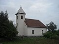
reformed Church
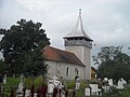
Orthodox Church
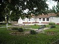
Bust of Petru Grozas in front of the Kulturhaus

Petru Groza's childhood home


Personalities
- Petru Groza (1884-1958), was a Romanian lawyer and communist politician, founder of the Ploughers' Front ( Frontul Plugarilor ).
Web links
Individual evidence
- ↑ 2011 census in Romania at citypopulation.de
- ^ Dictionary of the localities in Transylvania
- ↑ Heinz Heltmann, Gustav Servatius (Ed.): Travel Guide Siebenbürgen. Kraft, Würzburg 1993, ISBN 3-8083-2019-2 .
- ↑ Institute Of Archeology - Bacia, accessed 19 December 2010 (Romanian)
- ↑ Census, last updated November 2, 2008, p. 45 (Hungarian; PDF; 1.1 MB)
- ↑ Information on the Orthodox Church on lacasedecult.cimec.ro, accessed on December 19, 2010
- ↑ List of historical monuments of the Romanian Ministry of Culture, updated 2010 (PDF; 7.10 MB)
- ↑ Information on the Reformed Church at lacasedecult.cimec.ro, accessed on December 19, 2010
Băcia | Baia de Criș | Băița | Balșa | Bănița | Baru | Bătrâna | Beriu | Blăjeni | Boșorod | Brănișca | Bretea Română | Buceș | Bucureșci | Bulzeștii de Sus | Bunila | Burjuc | Cârjiți | Cerbăl | Certeju de Sus | Crișcior | Densuș | Dobra | General Berthelot | Ghelari | Gurasada | Hărău | Ilia | Lăpugiu de Jos | Read | Lunca Cernii de Jos | Luncoiu de Jos | Mărtineşti | Orăştioara de Sus | Pestișu Mic | Pui | Răchitova | Rapoltu Mare | Râu de Mori | Ribița | Romos | Sălașu de Sus | Sântămăria-Orlea | Sarmizegetusa | Șoimuș | Teliucu Inferior | Tomeşti | Toplița | Totești | Turdaș | Vălișoara | Vața de Jos | Vețel | Vorța | Zam