
Rapoltu Mare
|
Rapoltu Mare Groß-Rapolden Nagyrápolt |
|||||
|
|||||
| Basic data | |||||
|---|---|---|---|---|---|
| State : |
|
||||
| Historical region : | Transylvania | ||||
| Circle : | Hunedoara | ||||
| Coordinates : | 45 ° 52 ' N , 23 ° 5' E | ||||
| Time zone : | EET ( UTC +2) | ||||
| Height : | 227 m | ||||
| Area : | 80.99 km² | ||||
| Residents : | 1,960 (October 20, 2011) | ||||
| Population density : | 24 inhabitants per km² | ||||
| Postal code : | 337365 | ||||
| Telephone code : | (+40) 02 54 | ||||
| License plate : | HD | ||||
| Structure and administration (as of 2016) | |||||
| Community type : | local community | ||||
| Structure : | Rapoltu Mare, Bobâlna , Boiu , Folt , Rapolțel | ||||
| Mayor : | Octavian-Gheorghe Roman ( PSD ) | ||||
| Postal address : | Str. Principală, no. 67 loc. Rapoltu Mare, jud. Hunedoara, RO-337365 |
||||


Rapoltu Mare (outdated Rapolt ; German Groß-Rapolden , Hungarian Nagyrápolt ) is a municipality in the Hunedoara district in Transylvania , Romania .
Rapoltu Mare is also known under the German name Groß-Rapolten and the Hungarian Magyarrápolt and Rápolt .
Geographical location


The municipality of Rapoltu Mare is located on the right bank of the Mureș ( Mieresch ), south of the Transylvanian Ore Mountains . In the middle of the circle, the municipality is located in the historical region of Hunyad County ( Iron Market ). Located on the Lazu Bach and the district road ( drum județean ) DJ 107A, the place is about 7 kilometers northeast of the small town of Simeria ( Fischdorf ); the district capital Deva ( Diemrich ) is located about 17 kilometers west of Rapoltu Mare. On an area of about 8100 hectares, the four incorporated villages are located 2–9 kilometers from the community center.
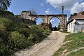
About seven kilometers east of Rapoltu Mare, in the incorporated village of Folt ( Foldt ), a ferry leads over the Mieresch to the village of Pricaz .
history
The place Rapoltu Mare was first mentioned in 1346. However, based on the findings of jasper jewelry on Mount Dobogo , according to M. Roska, the history of settlement in the region can be dated back to the Neolithic . Furthermore, according to information from G. Téglás , A. Fodor and J. Musterberg-Öhler , finds were made on a larger area in a westerly direction ( Uroi , Goldendorf ), which point to a settlement in Roman times ; pottery was found on Mount Dobogo - east of Rapoltu Mare.
About 43% of the community area is used for agriculture, 53% is forested. Because of the thermal springs on the area of the community, the construction of a small local recreation area is planned.
population
At the 1850 census, there were 3,305 people in the area of today's municipality. 2858 of them were Romanians , 188 Hungarians , 16 Germans and 243 others. The highest population (3540) was reached in 1880. The highest number of Romanians (3,191) was counted in 1900, that of Hungarians (278) was counted in 1910, that of Germans (50) in 1890 and that of Roma (240) in 1850. In addition, three residents identified themselves as Ukrainians in 1966, four in 1977, two in 1992 and one in 2002 . In 2002 there were 2066 people in the municipality of Rapoltu Mare, of whom 2011 were Romanians, 13 Hungarians, one German, 40 Roma and one Ukrainian.
Attractions
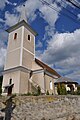
- The Hungarian Reformed hall church, built in the 14th century, with a polygonal apse and a reticulated vault from the 16th century, is a listed building. The tower and the main portal of the church are on the south side. Gothic wall paintings can still be seen in the church. A Roman lion is immured in the wall of the church.
- The Romanian Greek Catholic Church .
- The Romanian Orthodox Church was built in 1931.
- The Villa Daniel and all the associated property (chapel, mill, cellar, curtain walls), built in the 18th century, are listed buildings.
- An approximately 12.5 hectare nature reserve with tufa and travertine extends approximately two and a half kilometers along the formation Bobalna -Baches ( 45 ° 55 ' N , 23 ° 6' O ).
- The La Feredee -Thermalbad ( 45 ° 54 ' N , 23 ° 7' O ) on the site of unincorporated village Bobalna ( Baboln ).

South side of the reformed church

Roman lion, immured at the reformed church
Villa Daniel property

The Villa Daniel

Greek Catholic Church
Orthodox Church


Town twinning
Web links
Individual evidence
- ↑ 2011 census in Romania at citypopulation.de
- ^ Dictionary of the localities in Transylvania
- ↑ a b Heinz Heltmann, Gustav Servatius (Ed.): Travel Guide Siebenbürgen. Kraft, Würzburg 1993, ISBN 3-8083-2019-2 .
- ^ Institute Of Archeology - Rapoltu Mare, Rapoltu Mare Municipality, accessed on March 3, 2011 (Romanian)
- ^ Institute Of Archeology - Rapoltu Mare , accessed March 3, 2011 (Romanian).
- ↑ Rapoltu Mare on the website of the district of Hunedoara ( Memento from June 3, 2012 in the Internet Archive ) accessed on March 3, 2011 (Romanian)
- ↑ Census, last updated November 2, 2008, p. 126 (Hungarian; PDF file; 1.06 MB)
- ↑ View of the west side of the church (black and white picture) ( Memento from September 19, 2012 in the web archive archive.today )
- ↑ a b List of historical monuments of the Romanian Ministry of Culture, updated 2010 (PDF; 7.10 MB)
- ↑ Raluca Cîmpean: Description of the nature reserve with travertine in the valley of the Bobâlna , on www.europarc.ro, accessed on March 5, 2011 ( Memento of the original of August 24, 2013 in the Internet Archive ) Info: The archive link was inserted automatically and not yet checked. Please check the original and archive link according to the instructions and then remove this notice. (Romanian)
- ↑ Page no longer available , search in web archives: Alin Onu: "Die Schätze" von Rapoltu Mare , on Servus Hunedoara July 22, 2010 retrieved on March 5, 2011 (Romanian)
- ↑ Web presentation of the town twinning association Agneaux / Rapolt (French)
Băcia | Baia de Criș | Băița | Balșa | Bănița | Baru | Bătrâna | Beriu | Blăjeni | Boșorod | Brănișca | Bretea Română | Buceș | Bucureșci | Bulzeștii de Sus | Bunila | Burjuc | Cârjiți | Cerbăl | Certeju de Sus | Crișcior | Densuș | Dobra | General Berthelot | Ghelari | Gurasada | Hărău | Ilia | Lăpugiu de Jos | Read | Lunca Cernii de Jos | Luncoiu de Jos | Mărtineşti | Orăştioara de Sus | Pestișu Mic | Pui | Răchitova | Rapoltu Mare | Râu de Mori | Ribița | Romos | Sălașu de Sus | Sântămăria-Orlea | Sarmizegetusa | Șoimuș | Teliucu Inferior | Tomeşti | Toplița | Totești | Turdaș | Vălișoara | Vața de Jos | Vețel | Vorța | Zam