
Râu de Mori
|
Râu de Mori Mühlendorf Malomvíz |
|||||
|
|||||
| Basic data | |||||
|---|---|---|---|---|---|
| State : |
|
||||
| Historical region : | Transylvania | ||||
| Circle : | Hunedoara | ||||
| Coordinates : | 45 ° 30 ' N , 22 ° 51' E | ||||
| Time zone : | EET ( UTC +2) | ||||
| Height : | 506 m | ||||
| Area : | 386.12 km² | ||||
| Residents : | 3,153 (October 20, 2011) | ||||
| Population density : | 8 inhabitants per km² | ||||
| Postal code : | 337380 | ||||
| Telephone code : | (+40) 02 54 | ||||
| License plate : | HD | ||||
| Structure and administration (as of 2016) | |||||
| Community type : | local community | ||||
| Structure : | Râu de Mori, Brazi , Clopotiva , Ohaba-Sibișel , Ostrov , Ostrovel , Ostrovu Mic , Sibișel , Suseni , Unciuc , Valea Dâljii | ||||
| Mayor : | Niculiță Mang ( PNL ) | ||||
| Postal address : | Str. Principală, no. 1 loc. Râu de Mori, jud. Hunedoara, RO-337380 |
||||
| Website : | |||||


Râu de Mori , old spelling Rîu de Mori [ ˈrɨu de mor ] (outdated Suseni ; German Mühlendorf , Hungarian Malomvíz ), is a municipality in the Hunedoara district in Transylvania , Romania .
Râu de Mori is also known under the German name Mühldorf and the Hungarian Malomvize .
Geographical location

The municipality of Râu de Mori is located in the south-west of Transylvania in the Hatzeger Land ( Țara Hațegului ), in the northern foothills of the Retezat Mountains . Located on the Râuşor brook - a right tributary of the Râul Mare - and the county road ( drum județean ) DJ 686, the place is about 18 kilometers southwest of the small town of Hațeg ( Hatzeg ); the district capital Deva ( Diemrich ) is about 68 kilometers (42 km as the crow flies) north of Râu de Mori.
history
The place Râu de Mori, a former Hörigendorf , was first mentioned in 1359. On the basis of archaeological finds on an area called Livada lui Binder by the locals , according to information from Nemeș (1988–1991), Andrițoiu (1992) and Kalmar-Maxim (1999), the history of settlement in the region can be dated back to the Bronze Age . Furthermore, according to JM Ackner , I. Mallasz , I. Marțian u. a., finds from Roman times have been made. In the 15th century, the place Râu de Mori was one of the 30 villages of the small noble family Cândea (later Magyarized Kendeffy ).
Today the inhabitants live mainly from agriculture and wood processing. A hydropower plant is operated at the Ostrov reservoir .
population
In 1850, 3781 people lived in the area of today's municipality. 3,619 of them were Romanians , 73 Roma , 70 Magyars , eleven Transylvanian Saxons and eight others. The highest population (5304) - and at the same time that of the Romanians (5109) - was reached in 1977. The highest number of Hungarians (141) and that of Germans (55) were determined in 1910, the highest number of Roma (117) in 1956. In addition, in 1890 and 2002 one resident, four in 1977 as Ukrainians , in 1880, 1910 and 1977 two residents as Serbs , in 1910 and 1966 one resident as Slovak .
In 2002, 3546 people lived in the municipality of Râu de Mori, of whom 3428 were Romanians, 88 Roma, 25 Magyars, two Italians , one Ukrainian, one Lipovan and another.
Attractions
- The ruins of the estate of the Cândea family , built in the 14th century, are listed as historical monuments.
- The Ostrov reservoir, a reservoir of the Râul Mare river , north of the incorporated village of Ostrov (Groß-Rodendorf) .
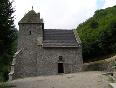
- The monastery Colt ( 45 ° 29 ' N , 22 ° 52' O , "Mănăstirea Colt"), with a stone church and watch tower in the 15th century by the family Candea donated, is located south of the unincorporated village Suseni . In the hall church with a small altar, wall paintings from the 15th century can be seen; is under monument protection.
- The ruins of the Fliehburg Cetatea Colț , about 2.5 kilometers (as the crow flies) southeast of Râu de Mori ( 45 ° 29 ′ N , 22 ° 52 ′ E , 716 m ), was built in the second half of the 14th century on behalf of Cândea of the small aristocracy, built in the 16th and 17th centuries with eight-meter-high defensive walls and a 12-meter-high defensive tower, is a listed building.
- The municipality is also the starting point for the peaks of the Retezat Mountains and the Retezater National Park ( Parcul Național Retezat ).
Web links
Individual evidence
- ↑ 2011 census in Romania at citypopulation.de
- ↑ a b c d e Heinz Heltmann, Gustav Servatius (ed.): Travel Guide Siebenbürgen. Kraft, Würzburg 1993, ISBN 3-8083-2019-2 .
- ^ Dictionary of the localities in Transylvania
- ↑ a b Sabin Adrian Luca: Archaeological information of the district of Hunedoara , p. 130, accessed on March 27, 2011 PDF 13.88 MB (Romanian)
- ^ Institute Of Archeology - Râu de Mori, accessed March 27, 2011 (Romanian)
- ↑ Census, last updated November 2, 2008, p. 131 (Hungarian; PDF; 1.1 MB)
- ↑ 2002 census, on www.edrc.ro (Romanian)
- ↑ a b c List of historical monuments of the Romanian Ministry of Culture, updated 2010 (PDF; 7.10 MB)
- ^ Image of the church of today's monastery Colț
- ↑ Presentation of the monastery on www.crestinortodox.ro, accessed on March 27, 2011 (Romanian)
Băcia | Baia de Criș | Băița | Balșa | Bănița | Baru | Bătrâna | Beriu | Blăjeni | Boșorod | Brănișca | Bretea Română | Buceș | Bucureșci | Bulzeștii de Sus | Bunila | Burjuc | Cârjiți | Cerbăl | Certeju de Sus | Crișcior | Densuș | Dobra | General Berthelot | Ghelari | Gurasada | Hărău | Ilia | Lăpugiu de Jos | Read | Lunca Cernii de Jos | Luncoiu de Jos | Mărtineşti | Orăştioara de Sus | Pestișu Mic | Pui | Răchitova | Rapoltu Mare | Râu de Mori | Ribița | Romos | Sălașu de Sus | Sântămăria-Orlea | Sarmizegetusa | Șoimuș | Teliucu Inferior | Tomeşti | Toplița | Totești | Turdaș | Vălișoara | Vața de Jos | Vețel | Vorța | Zam