
Sântămăria-Orlea
|
Sântămăria-Orlea Our Lady Őraljaboldogfalva |
|||||
|
|||||
| Basic data | |||||
|---|---|---|---|---|---|
| State : |
|
||||
| Historical region : | Transylvania | ||||
| Circle : | Hunedoara | ||||
| Coordinates : | 45 ° 35 ' N , 22 ° 58' E | ||||
| Time zone : | EET ( UTC +2) | ||||
| Height : | 310 m | ||||
| Area : | 67.80 km² | ||||
| Residents : | 3,251 (October 20, 2011) | ||||
| Population density : | 48 inhabitants per km² | ||||
| Postal code : | 337440 | ||||
| Telephone code : | (+40) 02 54 | ||||
| License plate : | HD | ||||
| Structure and administration (as of 2016) | |||||
| Community type : | local community | ||||
| Structure : | Sântămăria-Orlea, Balomir , Bărăştii-Hațegului , Bucium-Orlea , Ciopeia , Săcel , Sânpetru , Subcetate , Vadu | ||||
| Mayor : | Dumitru-Ioan Oprean ( PSD ) | ||||
| Postal address : | Str. Principală, no. 130 loc. Sântămăria-Orlea, jud. Hunedoara, RO-337440 |
||||
| Website : | |||||


Sântămăria-Orlea or old spelling Sîntămăria-Orlea [ ˈsɨntɘmɘria orlea ] ( German Liebfrauen , Hungarian Orlya-Boldogfalva or Őraljaboldogfalva ) is a municipality in the Hunedoara district in Transylvania , Romania .
The place is also known under the German name Mariendorf and the Hungarian Boldogasszonyfalva and Hátszegboldogasszonyfalva .
Geographical location

The municipality of Sântămăria-Orlea is located at the mouth of the Sibișel - a right tributary of the Râul Mare - in southwestern Transylvania in the Hatzeger Land ( Țara Hațegului ), north of the Retezat Mountains . Located on the European route 79 and the Simeria – Petroșani railway line , the place is about 10 kilometers south of the small town of Hațeg ( Hatzeg ); the district capital Deva ( Diemrich ) is 44 kilometers north of Sântămăria-Orlea.
The municipality's train station is located in the incorporated village of Subcetate ( suburb ), about 3 kilometers from Sântămăria-Orlea.
history
The place Sântămăria-Orlea was first mentioned in 1315 as the property of the small noble family Cândea. In the 15th century the place was given market rights .
According to reports by JM Ackner (1856), S. Moldovanu (1894), L. Kövári, JF Neigebauer and others, the history of settlement in the region goes back to the Hallstatt period . In the area of the village of Subcetate, near the train station, on the mountain Petriș (Măgura Orlea, 438 m above sea level ) called by the locals , archaeological finds were made which were assigned to the Neolithic Age . According to Neigebauer, Kövári and Ackner, there was also a Roman road on the area of the municipality .
Today the residents live mainly from cattle breeding and agriculture.
population
At the 1850 census, 2383 people lived in the area of today's municipality. 2192 of them were Romanians , 60 Hungarians , five Germans , 125 Roma and one other. The highest number of inhabitants (3996) - and also that of the Roma (289) - was reached in 1992. The highest number of Romanians (3813) was counted in 1966, that of Hungarians (377) in 1910 and that of Germans (47) in 1920. In addition, in some censuses, some residents identified themselves as Ukrainians , Serbs (one each in 1910 and 1930) and Slovaks . The highest number of Ukrainians (5) was reached in 1910 and that of Slovaks (6) in 1910. In 2002, 3522 people lived in the municipality of Sântămăria-Orlea, of whom 3270 were Romanians, 36 Hungarians, five Germans, 190 Roma, one Ukrainian, 18 Italians and two others.
Attractions
- The reformed church , donated by the Cândea family in the 13th century, is a Romanesque hall church with Gothic style elements on the vault; the bell tower faces west. The church was originally an Orthodox, later a Catholic and now a Reformed church, which can be recognized by the paintings from the 14th and 15th centuries in the nave. The church is also the burial place of the Cândea ( Kendeffy ) family and is a listed building.
- The Kendeffy Castle , built in the 18th century, renovated in the 19th century, with the property belonging to it is a listed building. A hotel has been operating in the castle since 1982.
- The orthodox stone church Sf. Gheorghe with altar paintings and the ruins of a castle of the Cândea family, built at the end of the 13th / beginning of the 14th century, in the incorporated village of Sânpetru are listed as historical monuments. Fossils were found on the area of the village , including those of the pterosaur Hatzegopteryx . Franz von Nopcsa (1815–1904) - one of the highest court officials of the Austro-Hungarian monarchy - was one of the first to discover fossils in the Hatzeg region .
- The ruins of the villa of the noble Nopcsa family, built in the 19th century, and the ruins of the old Romanian Orthodox church (built in the 17th century) in the incorporated village of Săcel ( Satschallen ), are listed as historical monuments. The village of Săcel is also the birthplace of the paleontologist Franz Nopcsa .
- The ruins of a hexagonal keep on Mount Petriş ( 45 ° 36 ' N , 22 ° 59' O ), a former royal castle with 200 sqm large courtyard, surrounded by an outer wall and moat, from the 13th and 14th centuries in the incorporated village of Subcetate , its three-meter-thick stone walls were probably built on the ruins of a Roman tower (according to M. Moga, 1937).
- The Sântămăria-Orlea , Păclișa and Covragiu-Subcetate reservoirs .

View of Sântămăria-Orlea
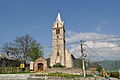
The church of Sântămăria-Orlea
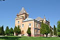
Kendeffy Castle

Front of the Church of Sânpetru

Back of the Sânpetru Church

The ruins of Villa Nopcsa in Săcel
.JPG)
.JPG)
.JPG)


Web links
Individual evidence
- ↑ 2011 census in Romania at citypopulation.de
- ^ Dictionary of the localities in Transylvania
- ^ A b Institute Of Archeology - Subcetate, accessed January 20, 2011 (Romanian)
- ^ A b Institute Of Archeology - Sântămăria-Orlea, accessed January 20, 2011 (Romanian)
- ↑ Census, last updated November 2, 2008, p. 144 (Hungarian; PDF; 1.1 MB)
- ↑ 2002 census (Romanian)
- ↑ a b c Heinz Heltmann, Gustav Servatius (ed.): Travel Guide Siebenbürgen. Kraft, Würzburg 1993, ISBN 3-8083-2019-2 .
- ↑ a b c d List of historical monuments of the Romanian Ministry of Culture, updated 2010 (PDF; 7.10 MB)
- ↑ a b Istoric information on the history of the community on its web presentation, accessed on October 8, 2012
- ↑ Information on the Geopark on the website of the Hunedoara district, accessed on January 20, 2011 ( memo of November 2, 2012 in the Internet Archive )
- ↑ Turism in Transilvania Castelul Nopcsa ( Memento from September 15, 2012 in the web archive archive.today ) History of the family and the castle of the Nopcsas (Romanian)
- ↑ Picture of the ruins of the keep, on rumaenienburgen.com ( Memento from September 8, 2012 in the web archive archive.today )
- ^ View of the Sântămăria-Orlea reservoir
- ↑ View of the Păclișa reservoir and the surrounding area
- ↑ View of the Covragiu-Subcetate reservoir and the surrounding area
Băcia | Baia de Criș | Băița | Balșa | Bănița | Baru | Bătrâna | Beriu | Blăjeni | Boșorod | Brănișca | Bretea Română | Buceș | Bucureșci | Bulzeștii de Sus | Bunila | Burjuc | Cârjiți | Cerbăl | Certeju de Sus | Crișcior | Densuș | Dobra | General Berthelot | Ghelari | Gurasada | Hărău | Ilia | Lăpugiu de Jos | Read | Lunca Cernii de Jos | Luncoiu de Jos | Mărtineşti | Orăştioara de Sus | Pestișu Mic | Pui | Răchitova | Rapoltu Mare | Râu de Mori | Ribița | Romos | Sălașu de Sus | Sântămăria-Orlea | Sarmizegetusa | Șoimuș | Teliucu Inferior | Tomeşti | Toplița | Totești | Turdaș | Vălișoara | Vața de Jos | Vețel | Vorța | Zam