
Teliucu Inferior
|
Teliucu Inferior Sub- Telek Alsótelek |
|||||
|
|||||
| Basic data | |||||
|---|---|---|---|---|---|
| State : |
|
||||
| Historical region : | Transylvania | ||||
| Circle : | Hunedoara | ||||
| Coordinates : | 45 ° 43 ' N , 22 ° 53' E | ||||
| Time zone : | EET ( UTC +2) | ||||
| Height : | 268 m | ||||
| Area : | 39.50 km² | ||||
| Residents : | 2,344 (October 20, 2011) | ||||
| Population density : | 59 inhabitants per km² | ||||
| Postal code : | 337465 | ||||
| Telephone code : | (+40) 02 54 | ||||
| License plate : | HD | ||||
| Structure and administration (as of 2016) | |||||
| Community type : | local community | ||||
| Structure : | Teliucu Inferior, Cinciș-Cerna , Izvoarele , Teliucu Superior | ||||
| Mayor : | Daniel-Gheorghe-Sorin Pupeză ( PNL ) | ||||
| Postal address : | St. Minei, no. 2 loc. Teliucu Inferior, jud. Hunedoara, RO-337465 |
||||
| Website : | |||||


Teliucu Inferior (outdated Teliuc or Teliucul de Jos ; German Untertelek , Hungarian Alsótelek ) is a municipality in the Hunedoara district in Transylvania , Romania .
The place is also known under the German name Eisenhammer and the Hungarian Telek .
Geographical location

The municipality of Teliucu Inferior is located in the southwest of the Transylvanian Basin, east of the Poiana-Ruscă Mountains , on the Cerna - a left tributary of the Mureș ( Mieresch ) - in the historical region of the Vajdahunyad chair district in Hunyad County ( Eisenmarkt county ). On the county road ( Drum județean ) DJ 687E, the place is five kilometers south of the city of Hunedoara ( iron market ); the district capital Deva ( Diemrich ) is located about 21 kilometers north of Teliucu Inferior.
history
The place Teliucu Inferior was first mentioned in a document in 1431 or 1477 under the Hungarian name Telethek , according to different sources . However, settlement in the region goes back further. According to reports by B. Pósta and M. Roska , archaeological finds from the Copper Age were made on the area of the municipality .
Since 1864 Eisenerz has been mined in the area of the municipality. After 1990 - the collapse of the mining industry in the region - is the main occupation of the population, the livestock , the agriculture and forestry .
population
In 1850 there were 1219 inhabitants on the territory of the municipality. 1023 of them were Romanians , 112 Hungarians and 84 Roma . The highest population of the municipality (6156) - at the same time that of the Romanians (5914) and that of the Hungarians (201) - was reached by leaps and bounds in 1966. The highest number of Roma was in 1850 and that of Romanian Germans (25) was counted in 1956. In addition, six in 1966, one in 1900, 1977 and 1992 each designated themselves as Ukrainians , in 1956 and 1966 one resident each designated themselves as a Serb and one resident in 1900, 1910 and 1930 as Slovaks . Since 1966 the population has declined sharply. In 2002, 2552 people lived in the area of the Teliucu Inferior municipality, of which 2489 were Romanians, 45 Magyars, nine Roma, four Transylvanian Saxons , three Ukrainians and two Lipovans .
Attractions
- The Cinciș Reservoir ( ⊙ ), built in 1964 south of Teliucu Inferior with a 48 meter high and about 220 meter long arch dam , is about 40 meters deep. With the creation of this reservoir, two villages and four hamlets were flooded. In the area of the flooded places there were also three Orthodox and one Roman Catholic churches . The churches of the former places Cinciş and Cerna were demolished and rebuilt in the newly created village of Cinciş-Cerna . The other two churches are now flooded on the edge of the lake. After several accidents with fatalities at the lake, it is called by the locals as the damn lake .
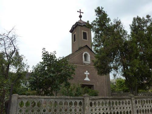
- The Catholic Church
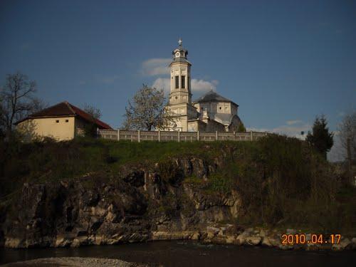
- The Orthodox Church was built in 1925.
photos
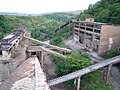
The ruins of an ore processing plant in Teliucu Inferior

Former mine near Teliucu Inferior

View of the Cinciș reservoir
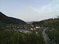
View of Teliucu Superior


Web links
Individual evidence
- ↑ 2011 census in Romania at citypopulation.de
- ^ Dictionary of the localities in Transylvania
- ↑ Heinz Heltmann, Gustav Servatius (Ed.): Travel Guide Siebenbürgen. Kraft, Würzburg 1993, ISBN 3-8083-2019-2 .
- ↑ Web presentation of the municipality of Teliucu Inferior ( Memento from 23 August 2013 in the Internet Archive )
- ^ Institute Of Archeology - Ilia, accessed November 20, 2011 (Romanian)
- ↑ Census, last updated November 4, 2008, p. 150 (Hungarian; PDF; 1.1 MB)
- ↑ Romanian Census 2002 (Hungarian)
- ↑ The area of today's Cinciş reservoir in the Josephinische Landaufnahme , with the places Cerna ( Cserna ) and Cinciş ( Csolnakos )
- ↑ Picture of the church before the flood
- ↑ Picture of the church after the flood
- ↑ Web presentation of the Cinciş reservoir
- ^ Picture of the Catholic Church in Teliucu Inferior
- ^ Picture of the Orthodox Church in Teliucu Inferior
- ↑ Information on the Orthodox Church at biserici.org accessed on January 6, 2012 (Romanian)
Băcia | Baia de Criș | Băița | Balșa | Bănița | Baru | Bătrâna | Beriu | Blăjeni | Boșorod | Brănișca | Bretea Română | Buceș | Bucureșci | Bulzeștii de Sus | Bunila | Burjuc | Cârjiți | Cerbăl | Certeju de Sus | Crișcior | Densuș | Dobra | General Berthelot | Ghelari | Gurasada | Hărău | Ilia | Lăpugiu de Jos | Read | Lunca Cernii de Jos | Luncoiu de Jos | Mărtineşti | Orăştioara de Sus | Pestișu Mic | Pui | Răchitova | Rapoltu Mare | Râu de Mori | Ribița | Romos | Sălașu de Sus | Sântămăria-Orlea | Sarmizegetusa | Șoimuș | Teliucu Inferior | Tomeşti | Toplița | Totești | Turdaș | Vălișoara | Vața de Jos | Vețel | Vorța | Zam