
Bucureșci
|
Bucureșci Bukuresd |
|||||
|
|||||
| Basic data | |||||
|---|---|---|---|---|---|
| State : |
|
||||
| Historical region : | Transylvania | ||||
| Circle : | Hunedoara | ||||
| Coordinates : | 46 ° 8 ' N , 22 ° 54' E | ||||
| Time zone : | EET ( UTC +2) | ||||
| Height : | 325 m | ||||
| Area : | 69.09 km² | ||||
| Residents : | 1,553 (October 20, 2011) | ||||
| Population density : | 22 inhabitants per km² | ||||
| Postal code : | 337145 | ||||
| Telephone code : | (+40) 02 54 | ||||
| License plate : | HD | ||||
| Structure and administration (as of 2016) | |||||
| Community type : | local community | ||||
| Structure : | Bucureșci, Curechiu , Merișor , Rovina , Șesuri | ||||
| Mayor : | Mircea-Florin Ghilean ( PNL ) | ||||
| Postal address : | Str. Principală, no. 25 loc. Bucureșci, jud. Hunedoara, RO-337145 |
||||
| Website : | |||||


Bucureșci [ bukuˈreʃtʃʲ ] (outdated București ; Hungarian Bukuresd ) is a municipality in the Hunedoara County in Transylvania , Romania .
The place is also known by the Romanian outdated names Bucureştii de Sus and Bucureştii de Jos and the Hungarian Alsóbukurest and Felsőbukurest .
Geographical location

The municipality of Bucureșci is located in the Brad depression ( Depresiunea Bradului ) north of the Transylvanian Ore Mountains ( Munții Metaliferi ), in the historical district of Brád (today Brad ) of Hunyad County ( Eisenmarkt County ). Located on the river of the same name - a left tributary of the Crișul Alb ( White Screech ) - and the county road ( drum județean ) DJ 741, the place is about 10 kilometers east of the small town of Brad ( Tannenhof ); the district capital Deva ( Diemrich ) is located about 45 kilometers south of Bucureșci.
history

A documentary mention of the place Bucureșci is only known since the Josephinian land survey from 1769 to 1773 under the names F. Bukaresd (Upper Bukaresd) and A. Bukaresd (Lower Bukaresd). On the Josephine map there is one church each in the hamlets of Upper and Lower Bukaresd and several stamping mills along the stream .
An occupation of the site is sufficient because of the gold deposits in the area of community - according to data of M. Pálfy - until the Romans back.
After the collapse of gold mining in the region, many people left the community or are now mainly involved in the timber industry.
population
Since the official survey of 1850, predominantly Romanians have been registered in the area of today's municipality . The highest population (3,169) - and at the same time that of the Romanians (3,151) - was determined in 1910. The highest population of the Roma (38) was registered in 1930, that of the Magyars (9) in 1966 and that of the Romanian Germans (5) in 1910. In 2002, 1924 people were counted in the municipality of Bucureșci. A Ukrainian was also registered in 2002 . At the 2011 census, 1,553 people were counted in 632 households in the parish.
In addition to forestry - the main occupation - beekeeping and the gathering of forest fruits are also notable occupations of the population.
Attractions
- The wooden church Sf. Nicolae , built in 1785 in the incorporated village of Curechiu , has numerous icons painted on wood and glass and is a listed building.
- The wooden church Înălțarea Sf. Cruci , built in 1780 and the Jurca family estate in the 19th century in the incorporated village of Rovina , are listed buildings.

Churches in Curechiu
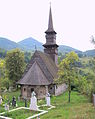
Wooden church in Curechiu
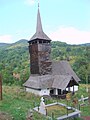
Wooden church in Rovina


Web links
Individual evidence
- ↑ 2011 census in Romania at citypopulation.de
- ^ Dictionary of the localities in Transylvania
- ^ Institute Of Archeology - Bucureșci, accessed March 10, 2013 (Romanian)
- ↑ Census, last updated November 2, 2008, p. 69 (Hungarian; PDF; 1.1 MB)
- ↑ Ethnic-demographic structure in Romania 2002 , Bucureșci at www.edrc.ro (Romanian, English; accessed on March 10, 2013)
- ↑ a b List of historical monuments of the Romanian Ministry of Culture, updated 2010 (PDF; 7.10 MB)
Băcia | Baia de Criș | Băița | Balșa | Bănița | Baru | Bătrâna | Beriu | Blăjeni | Boșorod | Brănișca | Bretea Română | Buceș | Bucureșci | Bulzeștii de Sus | Bunila | Burjuc | Cârjiți | Cerbăl | Certeju de Sus | Crișcior | Densuș | Dobra | General Berthelot | Ghelari | Gurasada | Hărău | Ilia | Lăpugiu de Jos | Read | Lunca Cernii de Jos | Luncoiu de Jos | Mărtineşti | Orăştioara de Sus | Pestișu Mic | Pui | Răchitova | Rapoltu Mare | Râu de Mori | Ribița | Romos | Sălașu de Sus | Sântămăria-Orlea | Sarmizegetusa | Șoimuș | Teliucu Inferior | Tomeşti | Toplița | Totești | Turdaș | Vălișoara | Vața de Jos | Vețel | Vorța | Zam