
Blăjeni
|
Blăjeni Blezseny |
|||||
|
|||||
| Basic data | |||||
|---|---|---|---|---|---|
| State : |
|
||||
| Historical region : | Transylvania | ||||
| Circle : | Hunedoara | ||||
| Coordinates : | 46 ° 13 ' N , 22 ° 54' E | ||||
| Time zone : | EET ( UTC +2) | ||||
| Height : | 375 m | ||||
| Area : | 88.62 km² | ||||
| Residents : | 1,192 (October 20, 2011) | ||||
| Population density : | 13 inhabitants per km² | ||||
| Postal code : | 337085 | ||||
| Telephone code : | (+40) 02 54 | ||||
| License plate : | HD | ||||
| Structure and administration (as of 2016) | |||||
| Community type : | local community | ||||
| Structure : | Blăjeni, Blăjeni-Vulcan , Criș , Dragu-Brad , Groșuri , Plai , Reț , Sălătruc | ||||
| Mayor : | Horia Flavius Jurca ( PNL ) | ||||
| Postal address : | Str. Principală, no. 85 loc. Blăjeni, jud. Hunedoara, RO-337085 |
||||
| Website : | |||||
| Others | |||||
| City Festival : | “La izvorul Crișului” ( At the source of the screeching ), annually on the last Sunday in June | ||||


Blăjeni ( Hungarian Blezseny or Balázsfalva ) is a municipality in the Hunedoara district in the Transylvania region in Romania .
Geographical location

The municipality Blajeni located in a mountainous landscape in the northern foothills of the Transylvanian Ore Mountains in the historic district chair Brad of Hunyader County (County Eisenmarkt) . In the north of the Hunedoara district on the district road (Drum județean) DJ 742B and on the upper reaches of the Crișul Alb (White Screech) , the village of Blăjeni , which consists of many hamlets , is about three kilometers north of the national road DN 74 , about halfway between the small towns Brad (Tannenhof) and Abrud (Großschlatten) in Kr. Alba . The town of Brad is 14 miles to the southwest; the district capital Deva (Diemrich) about 63 kilometers south of Blăjeni.
The northern area of the municipality is located in the southwest of the Motzenland .
history
The place Blăjeni is first mentioned in 1439; the incorporated villages are mentioned in a document at the beginning of the 20th century. On Mount Dealul Paltin , known by the locals , the leaders of the Romanian Horea uprising made the decision to carry out the uprising, with many farmers swearing their oath of loyalty. At the time of the Romanian Revolution of 1848 , its leader in Transylvania, Avram Iancu , is said to have hidden here in a cave for two weeks.
The main occupations of the population today are agriculture, livestock and fruit growing. About 63% of the community area is used for agriculture, 7% of which is arable land.
population
In 1850, 2333 inhabitants lived in the area of the municipality. 2290 of them were Romanians and 43 Roma . The largest population 3463 - at the same time that of the Romanians (3403) and that of the Roma (60) - was determined in 1930. The highest number of Magyars (13) was registered in 1900 and that of Germans (5) in 1890. At the 2002 census there were only 1530 Romanians living in the municipality. On October 31, 2011, a preliminary census in the municipality of Blăjeni, counted 1240 people in 681 households.
Attractions
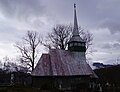
- The wooden churches in the incorporated villages of Groșuri and Sălătruc , as well as the old Motzen houses of the region.
- The municipality is a popular holiday area due to its karst landscape. The incorporated village of Blăjeni-Vulcan is a starting point for the Kalkberg Vulcan or Vâlcan . The mountain with 200–400 meter high steep walls is about five hectares and at the highest point ( ⊙ ) (according to different information) 1266 m or 1254 m high. A one and a half kilometer path leads to the mountain from the national road DN 74 in the Buceș Pass in a northerly direction.

Wooden church in Sălătruc
Wooden church in Groșuri

View of the Kalkberg Vulcan


.JPG)
Web links
Individual evidence
- ↑ 2011 census in Romania at citypopulation.de
- ^ Dictionary of the localities in Transylvania
- ↑ a b c d Information on the municipality's website ( memento of July 23, 2013 in the Internet Archive ), accessed on May 23, 2012
- ↑ a b c Heinz Heltmann, Gustav Servatius (ed.): Travel Guide Siebenbürgen. Kraft, Würzburg 1993, ISBN 3-8083-2019-2 .
- ↑ Census, last updated November 2, 2008, p. 56 (Hungarian; PDF; 1.1 MB)
- ^ Result of the preliminary census on October 31, 2011 (PDF; 176 kB)
- ↑ View of a Motzenhaus in Dragu Brad ( Memento from March 4, 2016 in the Internet Archive )
- ↑ View of the Kalkberg Vulcan ( Memento from September 23, 2015 in the Internet Archive )
Băcia | Baia de Criș | Băița | Balșa | Bănița | Baru | Bătrâna | Beriu | Blăjeni | Boșorod | Brănișca | Bretea Română | Buceș | Bucureșci | Bulzeștii de Sus | Bunila | Burjuc | Cârjiți | Cerbăl | Certeju de Sus | Crișcior | Densuș | Dobra | General Berthelot | Ghelari | Gurasada | Hărău | Ilia | Lăpugiu de Jos | Read | Lunca Cernii de Jos | Luncoiu de Jos | Mărtineşti | Orăştioara de Sus | Pestișu Mic | Pui | Răchitova | Rapoltu Mare | Râu de Mori | Ribița | Romos | Sălașu de Sus | Sântămăria-Orlea | Sarmizegetusa | Șoimuș | Teliucu Inferior | Tomeşti | Toplița | Totești | Turdaș | Vălișoara | Vața de Jos | Vețel | Vorța | Zam