
Abrud
|
Abrud Großschlatten Abrudbánya |
|||||
|
|||||
| Basic data | |||||
|---|---|---|---|---|---|
| State : |
|
||||
| Historical region : | Transylvania | ||||
| Circle : | Alba | ||||
| Coordinates : | 46 ° 16 ' N , 23 ° 4' E | ||||
| Time zone : | EET ( UTC +2) | ||||
| Height : | 627 m | ||||
| Area : | 3.20 km² | ||||
| Residents : | 5,072 (October 20, 2011) | ||||
| Population density : | 1,585 inhabitants per km² | ||||
| Postal code : | 515100 | ||||
| Telephone code : | (+40) 02 58 | ||||
| License plate : | FROM | ||||
| Structure and administration (as of 2016) | |||||
| Community type : | city | ||||
| Structure : | 3 districts / cadastral communities: Abrud-Sat , Gura Cornei , Soharu | ||||
| Mayor : | Nicolae Simina ( PSD ) | ||||
| Postal address : | Piața Eroilor, no. 1 loc. Abrud, jud. Alba, RO-515100 |
||||
| Website : | |||||


Abrud ( ung. Abrudbánya , dt. Großschlatten ) is a town in the Alba district in Romania . The river of the same name flows through the village.
history
The place Abrud was built on the foundations of a former Dako-Roman settlement around a numerus fort called " Abruttus ". In 1472 Abrud received city rights. In the Middle Ages, the city served as a defense system for the Roșia Montană gold mines , which are located north of Abrud. In 1559 a printing house was established in Abrud. During the uprising in 1784 , the peasant leaders Horea (Vasile Ursu Nicola), Cloşca (Ion Oargă) and Crişan (Marcu Giurgiu) fought against the Austrian army in Abrud.
traffic
The narrow-gauge railway Turda - Abrud has a station in Abrud.
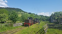
Narrow gauge railway in Abrud

View of Abrud


Web links
Individual evidence
- ↑ 2011 census in Romania ( MS Excel ; 1.3 MB)
- ↑ Mayoral elections 2016 in Romania ( MS Excel ; 256 kB)
Abrud | Aiud | Alba Iulia | Baia de Arieș | Blaj | Câmpeni | Cugir | Ocna Mureș | Sebeș | Teiuș | Zlatna