
Cârjiți
|
Cârjiți Kerschdorf Kersec |
|||||
|
|||||
| Basic data | |||||
|---|---|---|---|---|---|
| State : |
|
||||
| Historical region : | Transylvania | ||||
| Circle : | Hunedoara | ||||
| Coordinates : | 45 ° 51 ' N , 22 ° 50' E | ||||
| Time zone : | EET ( UTC +2) | ||||
| Height : | 370 m | ||||
| Area : | 45.75 km² | ||||
| Residents : | 681 (October 20, 2011) | ||||
| Population density : | 15 inhabitants per km² | ||||
| Postal code : | 337175 | ||||
| Telephone code : | (+40) 02 54 | ||||
| License plate : | HD | ||||
| Structure and administration (as of 2016) | |||||
| Community type : | local community | ||||
| Structure : | Cârjiți, Almaşu Sec , Chergheş , Cozia , Popeşti | ||||
| Mayor : | Daniela-Maria Adam ( PNL ) | ||||
| Postal address : | Str. Principală, no. 1 loc. Cârjiți, jud. Hunedoara, RO-337175 |
||||


Cârjiți , old spelling Cîrjiți [ ˈkɨrʒitzʲ ] (outdated Chirșiți ; German Kerschdorf , Hungarian Kersec ) is a municipality in the Hunedoara district , in Transylvania , Romania .
Geographical location

Located in the southwest of Transylvania, the municipality is located in the center of the Hunedoara district. The municipality is located in the northeastern foothills of the Poiana-Ruscă Mountains on an area of around 4500 hectares . On the upper reaches of the Cristurs - a left tributary of the Cerna - and on the district road ( drum județean ) DJ 708E, the town of Cârjiți is nine kilometers southwest of the district capital Deva ( Diemrich ).
history
The place Cârjiți was mentioned for the first time in 1453. According to Márton Roska, archaeological finds on the site point to the Neolithic and are in the museum in Deva. According to reports by C. Gooss (1877), Grigore Tocilescu , Gábor Téglás (1887) and others. a., in the north of the place - called Grohote by the locals - finds were made which point to a settlement in the Early Bronze Age , as well as numerous finds which point to mining in Roman times .
In the area of the incorporated village of Almașu Sec (Hungarian Szárazalmás ) finds have been made which point to settlement in the Bronze Age ; at Chergheș (Hungarian Kerges ), according to information from Márton Roska and Ion Nestor, numerous finds that point to the Late Bronze Age were made.
On the Piatra Coziei mountain , at 686 m between the incorporated village of Cozia (Hungarian Kozolya ) and the village of Herepeia in the municipality of Vețel , remains of a Dacian fortress have been found.
population
In 1850, 1395 people lived in the area of today's municipality. 1366 were Romanians and 29 were Roma . The largest population (2149) - also that of the Romanians (2084) and the Germans (13) - was determined in 1910 and has steadily decreased since then. The highest number of Magyars (14) was registered in 1880 and that of Roma (65) in 1930. In 2002 there were 798 people in the community, 794 of whom were Romanians, three Hungarians and one German. The 2011 census showed a population of 681 residents in the municipality. 654 of them were Romanians, two were Magyars, the rest were registered without any ethnic information.
The main occupation of the population is agriculture and livestock.
Attractions
- In the incorporated village of Chergheş, the wooden church Cuvioasa Paraschiva , built according to various sources in the 17th or 18th century, is a listed building.

The wooden church in Chergheș
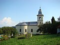
Church in Popeşti


Web links
Individual evidence
- ↑ a b 2011 census in Romania ( MS Excel ; 1.3 MB)
- ^ Dictionary of the localities in Transylvania
- ↑ Heinz Heltmann, Gustav Servatius (Ed.): Travel Guide Siebenbürgen. Kraft, Würzburg 1993, ISBN 3-8083-2019-2 .
- ↑ Institute Of Archeology - Cârjiți at cimec.ro, accessed on July 22, 2013 (Romanian)
- ↑ a b c List of historical monuments of the Romanian Ministry of Culture, updated 2010 (PDF; 7.10 MB)
- ↑ Institute Of Archeology - Chergheș at cimec.ro, accessed on July 22, 2013 (Romanian)
- ↑ Statistical data on Cârjiți at transindex.ro, accessed on July 23, 2013 (Hungarian)
- ↑ Information on the church in Chergheș on www.cimec.ro, accessed on July 24, 2013
Băcia | Baia de Criș | Băița | Balșa | Bănița | Baru | Bătrâna | Beriu | Blăjeni | Boșorod | Brănișca | Bretea Română | Buceș | Bucureșci | Bulzeștii de Sus | Bunila | Burjuc | Cârjiți | Cerbăl | Certeju de Sus | Crișcior | Densuș | Dobra | General Berthelot | Ghelari | Gurasada | Hărău | Ilia | Lăpugiu de Jos | Read | Lunca Cernii de Jos | Luncoiu de Jos | Mărtineşti | Orăştioara de Sus | Pestișu Mic | Pui | Răchitova | Rapoltu Mare | Râu de Mori | Ribița | Romos | Sălașu de Sus | Sântămăria-Orlea | Sarmizegetusa | Șoimuș | Teliucu Inferior | Tomeşti | Toplița | Totești | Turdaș | Vălișoara | Vața de Jos | Vețel | Vorța | Zam