
Buceș
|
Buceș Bucsesd |
|||||
|
|||||
| Basic data | |||||
|---|---|---|---|---|---|
| State : |
|
||||
| Historical region : | Transylvania | ||||
| Circle : | Hunedoara | ||||
| Coordinates : | 46 ° 11 ' N , 22 ° 56' E | ||||
| Time zone : | EET ( UTC +2) | ||||
| Height : | 361 m | ||||
| Area : | 122.63 km² | ||||
| Residents : | 1,961 (October 20, 2011) | ||||
| Population density : | 16 inhabitants per km² | ||||
| Postal code : | 337135 | ||||
| Telephone code : | (+40) 02 54 | ||||
| License plate : | HD | ||||
| Structure and administration (as of 2016) | |||||
| Community type : | local community | ||||
| Structure : | Buceș, Buceș-Vulcan , Dupăpiatră , Grohoțele , Mihăileni , Stănija , Tarnița | ||||
| Mayor : | Traian Achim-Mărcuș ( PSD ) | ||||
| Postal address : | Str. Principală, no. 79 loc. Buceș, jud. Hunedoara, RO-337135 |
||||
| Website : | |||||


Buceș [ ˈbutʃeʃ ] ( Hungarian Bucsesd or Bukásfalva ) is a municipality in Hunedoara County in Transylvania , Romania .
Geographical location

The municipality of Buceș is located on the creek of the same name - a left tributary of the Crișul Alb ( White Screech ) - in a mountainous landscape north of the Transylvanian Ore Mountains in the historic district of Brád (today Brad ) of Hunyad County ( Eisenmarkt County ). In the north of the district of Hunedoara the place is (according to different height indications: 361 m) on the national road ( Drum național ) DN 74 ( Brad - Abrud , Kr. Alba ) 19 kilometers northeast of the small town Brad ( Tannenhof ); the district capital Deva ( Diemrich ) is about 60 kilometers south of Buceș.
In the north of the incorporated village of Buceș-Vulcan , the national road 74 leads seven kilometers over the 725 meter high Buceș Pass , ( ⊙ ) into the Alba district.
history
A more precise first registration of the place is not known. Some sources claim that Buceș was first mentioned in documents in 1439. According to reports by G. Téglás , P. Király , TP Ghiţulescu and others, the history of the settlement of the region goes back to Roman times due to the finds of gold mines and other archaeological finds on the area of the incorporated village of Stănija ( Stannsdorf ) . The municipality of Buceş was the center of non-ferrous and precious metal ore mining.
Because of the gold deposits in the region, the population of the community was tortured to death by the Securitate in the 1950s for presumably illegal gold possession .
Ioan Cătălina from Stănija, the only authorized gold prospector in Romania, received the concession to prospect for gold in 2005 after six years of being overwhelmed by the authorities. Cătălina succeeds in finding around 30 grams of gold per year (2011).
population
In 1850, 3939 inhabitants lived in the area of today's municipality. 3732 of them were Romanians and 207 were Roma . In 1910 the largest population was determined with 4838. The highest number of Romanians (4789) was registered in 1941, that of Roma in 1850, that of Hungarians (41) and that of Germans (21) in 1890. In addition, in 1890, 1900, 1910 and 1966 one resident each referred to himself as a Slovak . At the 2002 census, 2381 people lived in the municipality, 2251 of whom were Romanians, 129 Roma and one Hungarian. In 2011 there were 1923 Romanians, 24 Roma and 14 did not provide any information about their ethnicity .
Attractions
- The wayside cross erected in Buceș in 1934 is a listed building.
- The wooden church Adormirea Maicii Domnului , built in 1840 in the incorporated village of Stănija, renovated in 2010, is a listed building.
- The Kalkberg Vulcan or also called Vâlcan , at the highest point ( ⊙ ) 1263 m high, is a five-hectare mountain with 200-400 meter high steep walls. A one and a half kilometer long path leads to the mountain from the national road in the Buceș Pass in a northerly direction.
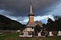
Wooden church in Stănija

Church in Mihăileni

Mount Vulcan


Web links
Individual evidence
- ↑ 2011 census in Romania at citypopulation.de
- ^ Dictionary of the localities in Transylvania
- ↑ a b Heinz Heltmann, Gustav Servatius (Ed.): Travel Guide Siebenbürgen. Kraft, Würzburg 1993, ISBN 3-8083-2019-2 .
- ↑ a b Short history on the website of the municipality , accessed on April 1, 2012 (Romanian)
- ↑ Institute Of Archeology - Stanija, accessed on 1 April 2012. (Romanian)
- ↑ Tiberiu Stroia: Last prospector in Romania on Adevărul.ro from March 6, 2011, accessed on April 1, 2012 (Romanian)
- ↑ Census, last updated November 4, 2008, p. 67 (Hungarian; PDF file; 1.06 MB)
- ↑ 2011 census in Romania ( MS Excel ; 1.3 MB)
- ↑ a b List of historical monuments of the Romanian Ministry of Culture, updated 2010 (PDF; 7.10 MB)
- ↑ Localizare
Băcia | Baia de Criș | Băița | Balșa | Bănița | Baru | Bătrâna | Beriu | Blăjeni | Boșorod | Brănișca | Bretea Română | Buceș | Bucureșci | Bulzeștii de Sus | Bunila | Burjuc | Cârjiți | Cerbăl | Certeju de Sus | Crișcior | Densuș | Dobra | General Berthelot | Ghelari | Gurasada | Hărău | Ilia | Lăpugiu de Jos | Read | Lunca Cernii de Jos | Luncoiu de Jos | Mărtineşti | Orăştioara de Sus | Pestișu Mic | Pui | Răchitova | Rapoltu Mare | Râu de Mori | Ribița | Romos | Sălașu de Sus | Sântămăria-Orlea | Sarmizegetusa | Șoimuș | Teliucu Inferior | Tomeşti | Toplița | Totești | Turdaș | Vălișoara | Vața de Jos | Vețel | Vorța | Zam