
Vețel
|
Vețel Witzel Vecel |
|||||
|
|||||
| Basic data | |||||
|---|---|---|---|---|---|
| State : |
|
||||
| Historical region : | Transylvania | ||||
| Circle : | Hunedoara | ||||
| Coordinates : | 45 ° 54 ' N , 22 ° 48' E | ||||
| Time zone : | EET ( UTC +2) | ||||
| Height : | 190 m | ||||
| Area : | 113.89 km² | ||||
| Residents : | 2,872 (October 20, 2011) | ||||
| Population density : | 25 inhabitants per km² | ||||
| Postal code : | 337525 | ||||
| Telephone code : | (+40) 02 54 | ||||
| License plate : | HD | ||||
| Structure and administration (as of 2016) | |||||
| Community type : | local community | ||||
| Structure : | Vețel, Boia Bârzii , Bretelin , Căoi , Herepeia , Leșnic , Mintia , Muncelu Mare , Muncelu Mic , Runcu Mic | ||||
| Mayor : | Ioan Hențiu ( PSD ) | ||||
| Postal address : | Mihai Eminescu Street, no. 256 loc. Vețel, jud. Hunedoara, RO-337525 |
||||
| Website : | |||||


Vețel [ ˈvetsel ] (outdated Vițel , literally: "Kalb"; German Witzel , Hungarian Vecel ) is a municipality in the Hunedoara district in Transylvania , Romania .
Geographical location

The municipality of Vețel is located in the southwest of the Transylvanian Basin , north of the Poiana-Ruscă Mountains . At the confluence of the Vețel and Vulcez brooks - left tributaries of the Mureș ( Mieresch ) - in the center of the Hunedoara district, the place is located on the European route 68 and the double- track Arad – Alba Iulia railway about 13 kilometers west of the district capital Deva ( Diemrich ) away.
35.86% of the total area of the municipality is used for agriculture, 58.36% is forested.
history
The place Vețel was first mentioned in a document in 1278 or 1371 (according to different sources). According to reports by F. Kenner , I Hampel , A. Koch , G. Téglás , I. Andrieşecu and others, the history of settlement in the region goes back to the Early Bronze Age . Many of these finds are in museums in Bucharest and Budapest . Furthermore, numerous finds from Roman times were made on the site . Vețel was a Hungarian settlement in the Middle Ages. Romanians also settled here in the 15th century and a Romanian district emerged. The place has been inhabited almost exclusively by Romanians since the 16th century.
On the area of the incorporated village of Mintia ( Bayersdorf ), one of the largest thermal power plants in Romania was built between 1960 and 1970 ( 45 ° 55 ' N , 22 ° 49' E , "SC Electrocentrale Deva SA"). For several years, the operation of the power station has documented negative effects on the environment through water pollution, soil damage and the destruction of vegetation.
After the decline of the mining industry, the inhabitants now live mainly from agriculture.
population
At the 1850 census, there were 2583 people in the area that is now the municipality. 2,400 of them were Romanians , 126 Roma , 43 Hungarians , ten Germans and four others. The highest population (4090) - both Romanians (3818) and Hungarians (194) - was reached in 1977. The highest number of Roma was counted in 1850 and that of Germans (26) in 1900. In addition, 24 inhabitants in 1880, three inhabitants in 1910 and 1992 and one in 2002 as Slovaks , and in 2002 two inhabitants as Ukrainians . In 2002 there were 2,760 people in the entire municipality of Ve Gemeindeel, of which 2,527 were Romanians, 129 Hungarians, 98 Roma and three Germans.
Attractions
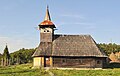
- The wooden church Cuvioasa Paraschiva , built in 1790, is a listed building.
- The ruins of the Roman fort Micia - located next to the railway line - with its camp village ( vicus ), which includes a port on the Mieresch, public buildings such as a Jupiter temple, thermal baths and a small amphitheater . The area is a listed building.
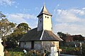
- In unincorporated village Boia Barzii ( Ochsendorf ) the wooden church Pogorârea Sf. Duh , built in the 18th century, is a listed building.
- In the incorporated village of Herepeia (ung. Herepe ) the wooden church Cuvioasa Paraschiva , built in the 18th century, is a listed building.
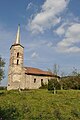
- In the incorporated village of Leșnic ( Wachtdorf ) the Romanian Orthodox Church Sf. Nicolae , was founded around 1400 by Dobre Românul (a Romanian servant ), who was ennobled by King Sigismund of Luxembourg for his bravery ; is under monument protection.
- In the incorporated village of Mintia the Hungarian Reformed hall church (built in the 16th century) and the estate of Gyulay Ferencz , built in 1642, rebuilt in 1834; are under monument protection.
- In the incorporated village of Muncelu Mare (Hungarian Nagymuncsel ) the wooden church Duminica Tuturor Sfinților , built in 1762, is a listed building.

Church in Vețel
Church in Boia Bârzii

Church in Leșnic
Church in Mintia

Church in Muncelu Mare
Church in Muncelu Mic

Church in Runcu Mic

Thermal power plant at Mintia


Sons and daughters of the church
- Francisc Munteanu (1924–1993), Romanian writer, film director and screenwriter
Web links
Individual evidence
- ↑ 2011 census in Romania at citypopulation.de
- ↑ a b c d Heinz Heltmann, Gustav Servatius (Ed.): Travel Guide Siebenbürgen. Kraft, Würzburg 1993, ISBN 3-8083-2019-2 .
- ↑ History, web representation of the community, accessed on April 23, 2011 ( Memento of the original from June 10, 2012 in the Internet Archive ) Info: The archive link was inserted automatically and has not yet been checked. Please check the original and archive link according to the instructions and then remove this notice.
- ^ Institute Of Archeology - Vețel, accessed April 23, 2011 (Romanian)
- ↑ Web presentation of the Mintia thermal power station
- ↑ Economy, web presentation of the community, accessed on April 23, 2011 ( Memento of the original from May 18, 2013 in the Internet Archive ) Info: The archive link was inserted automatically and has not yet been checked. Please check the original and archive link according to the instructions and then remove this notice.
- ↑ Census, last updated November 2, 2008, p. 167 (Hungarian; PDF; 1.1 MB)
- ↑ Information about the church on www.cimec.ro, accessed on January 8, 2013
- ↑ a b c d e f g List of historical monuments of the Romanian Ministry of Culture, updated 2010 (PDF; 7.10 MB)
Băcia | Baia de Criș | Băița | Balșa | Bănița | Baru | Bătrâna | Beriu | Blăjeni | Boșorod | Brănișca | Bretea Română | Buceș | Bucureșci | Bulzeștii de Sus | Bunila | Burjuc | Cârjiți | Cerbăl | Certeju de Sus | Crișcior | Densuș | Dobra | General Berthelot | Ghelari | Gurasada | Hărău | Ilia | Lăpugiu de Jos | Read | Lunca Cernii de Jos | Luncoiu de Jos | Mărtineşti | Orăştioara de Sus | Pestișu Mic | Pui | Răchitova | Rapoltu Mare | Râu de Mori | Ribița | Romos | Sălașu de Sus | Sântămăria-Orlea | Sarmizegetusa | Șoimuș | Teliucu Inferior | Tomeşti | Toplița | Totești | Turdaș | Vălișoara | Vața de Jos | Vețel | Vorța | Zam