
Călan
|
Călan Kalan Pusztakalán |
|||||
|
|||||
| Basic data | |||||
|---|---|---|---|---|---|
| State : |
|
||||
| Historical region : | Transylvania | ||||
| Circle : | Hunedoara | ||||
| Coordinates : | 45 ° 44 ′ N , 22 ° 59 ′ E | ||||
| Time zone : | EET ( UTC +2) | ||||
| Height : | 227 m | ||||
| Area : | 101.55 km² | ||||
| Residents : | 11,279 (October 20, 2011) | ||||
| Population density : | 111 inhabitants per km² | ||||
| Postal code : | 335300 | ||||
| Telephone code : | (+40) 02 54 | ||||
| License plate : | HD | ||||
| Structure and administration (as of 2016) | |||||
| Community type : | city | ||||
| Structure : | 12 districts / cadastral municipalities: Batiz , Călanu Mic , Grid , Nădăștia de Jos , Nădăștia de Sus , Ohaba Streiului , Sâncrai , Sântămăria de Piatră , Strei , Strei-Săcel , Streisângeorgiu , Valea Sângeorgiului | ||||
| Mayor : | Filip-Adrian Iovănesc ( PNL ) | ||||
| Postal address : | St. Gării, no. 1 loc. Călan, jud. Hunedoara, RO-335300 |
||||
| Website : | |||||


Călan ( ; outdated Crișeni ; German Kalan , Hungarian Pusztakalán ) is a small town in the Hunedoara district in Transylvania , Romania .
The place is also known under the German name Klandorf and the Hungarian Kalán .
Geographical location

The small town of Călan is located in the southern half of the Hunedoara district on the Strei ( Strell ) - a tributary of the Mureș ( Mieresch ) - in the Hatzeger valley basin ( Depresiunea Hațeg ). Simeria is about 14 kilometers north, the district capital Deva ( Diemrich ) about 25 kilometers northwest of Călan.
history
The oldest archaeological evidence of settlement in the region comes from the Neolithic Age . On the territory of the present city there was a Dacian settlement called Ydata , which continued under the name Aquae during the Roman Empire .
Călan was first mentioned in a document in 1387. The name possibly goes back to a bishop Calanus , who owned land in the vicinity of the place. In 1760 the Hungarian name Pusztakalán is proven. During this time, iron smelting began in Călan , which grew in importance in the second half of the 19th century. The first blast furnace was built in 1869 . Workers' settlements were built in the previously rural town. After the Second World War, Călan developed - with the “Victoria” steelworks - into a center of metallurgy in Romania. The settlement of Nou Călan was built on the right side of the Strei . In 1961 the place was declared a city. Other important branches of the economy are the textile and construction industries. After the revolution in 1989 , some steelworks were shut down, so that today (2010) the plant looks like a ruin; several industrial areas need to be renovated. Only 250-300 people are employed in the former steelworks - mostly on guard duties.
population
In 1850, 5474 inhabitants were registered in the area of today's town, of which only 165 lived in Călan, the remaining 5309 in the towns that are now incorporated. About 97% were Romanians . The economic development led to the influx of other nationalities, especially from Hungarians . In the - albeit controversial - census in 1910, the population had risen to 7,272, of which 5807 identified themselves as Romanians, 1110 as Hungarians and 285 as Germans . At that time, 1024 people lived in Călan itself. The population continued to grow by 1992 (14,738). Since then the population has been falling slowly. In the 2002 census, 13,030 people lived in Călan, 9,359 of them in the city proper and 3,671 in the cadastral communities . 11,965 identified themselves as Romanians, 800 as Hungarians, 174 as Germans and 67 as Roma . Furthermore, in almost every recording, some referred to themselves as Slovaks (the highest number in 1930) and Serbs (the highest number in 1966); from 1956 Ukrainians were also registered (the highest number in 1977).
traffic
Călan is located on the double-track and electrified Simeria – Petroșani railway line . Express trains also stop in Călan, and only local trains stop in Călan Bai . There is regular bus service to Deva and Hunedoara . The national road ( drum național ) DN 66 runs through the city - in north-south direction - from Simeria to Filiași ( Kr. Dolj ), which here corresponds to European route 79 .
Attractions
- The Roman bath Ad Aquae , carved into a rock in the 3rd century, has a circumference of approx. 94 m, is 14.2 m long, 7.5 m wide and 4 m deep. Called “lingura” ( spoon ) by the locals , the bath was supplied with water from three springs at a temperature of 23 to 24 ° C. After the third blast furnace in the ironworks went into operation in 1980, the bath was covered with soot, ashes and coal dust, making it unusable. The bathroom is a listed building.
- The Reformed Church, built in 1895.
- The Orthodox Church, built in 1938.
- The Orthodox Church of Sf. Gheorghe in Streisângeorgiu, built in the 13th century, was a foundation of the Cîndea family (Hungarian Kendeffi ). The oldest layer of wall painting from 1313 by the master painter Teofil can be found on the niche for the altar. Restored in 1409, it is a listed building.
- A hydropower plant in Streisângeorgiu - in the direction of Boșorod - was built at the end of the 19th century and is a listed building.
- The orthodox church Adormirea Maicii Domnului in Strei in the 13./14. Built in the 19th century, it is a listed building.

Roman bath

Blast furnace in Călan, 1896

Ruin of the iron and steel works

New district
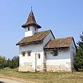
Church in Streisângeorgiu

Hydroelectric power station in Streisângeorgiu


.jpg)


Personalities
- Gheorghe Barbu (* 1951), Romanian Minister of Labor, Family and Social Affairs
Web links
Individual evidence
- ↑ 2011 census in Romania at citypopulation.de
- ^ Dictionary of localities from Transylvania
- ^ Institute Of Archeology - Călan, accessed December 21, 2010 (Romanian)
- ↑ a b c Website of the city, accessed on December 20, 2010 ( Memento of the original from October 12, 2012 in the Internet Archive ) Info: The archive link was inserted automatically and has not yet been checked. Please check the original and archive link according to the instructions and then remove this notice.
- ↑ Census, last updated November 2, 2008, p. 15 (Hungarian; PDF; 1.1 MB)
- ↑ a b c List of historical monuments of the Romanian Ministry of Culture, updated 2010 (PDF; 7.10 MB)
- ↑ Information on the Reformed Church on lacasedecult.cimec.ro, accessed on December 20, 2010
- ↑ Information on the Orthodox Church on lacasedecult.cimec.ro, accessed on December 20, 2010
- ↑ Heinz Heltmann, Gustav Servatius (Ed.): Travel Guide Siebenbürgen. Kraft, Würzburg 1993, ISBN 3-8083-2019-2 .
- ^ Gheorghe Barbu on the website of the Romanian House of Representatives