Carpathian Ukraine
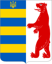
The Carpathian Ukraine , and Sub-Carpathia , or more modern and more frequently Transcarpathia ( Ukrainian Закарпаття Sakarpatia or Карпатська Україна Karpatska Ukrajina ) is a historical region in the far west of today's Ukraine , which in Romania , Hungary , the Slovak Republic and Poland borders. It mainly includes the area of the Ukrainian part of the Carpathians , today's administrative unit Zakarpattia Oblast (Sakarpatska Oblast) . The biggest cities are Uzhhorod and Mukachevo .
Other names
Another name for the region is Ruthenia ; from the perspective of Ukraine's her name Transcarpathia , from the perspective of Central Europe Subkarpatien ( Czech and Slovak Podkarpatsko , Hungarian Kárpátalja , Polish Zakarpacie or Podkarpacie ), as part of Czechoslovakia Ruthenia (Podkarpatská Rus) and as part of the Kingdom of Hungary Northeastern Upper Hungary (Észak-Keleti Felvidék) . The Hungarian name - Kárpátalja (Subcarpathian, "Lower Carpathian") - has been used since the First Vienna Arbitration .
population
Traditionally, the approximately 1.3 million inhabitants belong to different peoples , but above all to the Russians (often misunderstood as Ruthenians ) and Ukrainians . In addition to these ethnic groups (Russians estimated 400,000 and Ukrainians around 600,000) there is also a large minority of Hungarians (officially 151,000) in the south in the lowlands on the border with Hungary . About 40,000 Romanians live in the southeast on the border with Romania . The number of Jews and Germans (currently around 3,000 Carpathian Germans ) fell significantly during and after World War II . Of almost 100,000 Jews, around 90% were murdered in the Holocaust . After 1945 it was mainly Russians who immigrated and now, in places, they are ethnically homogeneous localities.
In 1880, according to a census in the area of Carpathian Ukraine, the population distribution was as follows:
- Ruthenians (Russians and Ukrainians) = 244,742 (59.8%)
- Hungary = 105,343 (25.7%)
- Germans = 31,745 (7.8%)
- Romanians = 16,713 (4.1%)
- Slovaks and Czechs = 8,611 (2.1%)
- other ethnic groups = 1,817 (0.5%)
As part of Czechoslovakia, what is now known as Carpathian or Carpathian Russia had the following population distribution in a 1930 census (of a total of 725,357 inhabitants):
- Ruthenians = 450,925 (62.17%)
- Hungary = 115,805 (15.96%)
- Jews = 95,008 (13.10%)
- Czechs and Slovaks (combined within the framework of Czechoslovakism ) = 34,511 (4.76%)
- Germans = 13,804 (1.9%)
- Romanians = 12,777 (1.8%)
- Others ( Gypsies , Poles , Yugoslavs ) = 2,527 (0.3%)
About 60 years later, at the 1989 census in the still existing Soviet Union , the distribution was as follows:
- Ukrainians = 976,749 (78.4%)
- Hungary = 155,711 (12.5%)
- Russians = 49,456 (4.0%)
- Romanians = 29,485 (2.4%)
- others ( Roma , Slovaks , Germans ) = 33,638 (2.7%)
In 2001 a census in the country now part of Ukraine ( Transcarpathian Oblast ) showed the following results:
- Ukrainians = 1,010,100 (80.5%)
- Hungary = 151,500 (12.1%)
- Romanians = 32,100 (2.6%)
- Russians = 31,000 (2.5%)
- Roma = 14,000 (1.1%)
- Slovaks = 5,600 (0.5%)
- Germans = 3,500 (0.3%)
The Russians or Ruthenians living in Ukraine are today - unlike before 1945 - not recognized as their own nationality , but only as an ethnic group within the Ukrainians. Only about 1% of the population (10,100 people) therefore gave their nationality "Russian" in the last census.
history
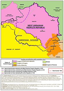
In the 9th century the area was part of Great Moravia , from the 10th century to 1920 the area belonged to the Kingdom of Hungary , and thus (until 1918) to the Habsburg monarchy . It was there in Ung , Bereg , Ugocsa , Máramaros counties and in small parts in Szatmár counties .
After the end of the First World War , the area came under the Treaty of Trianon to Czechoslovakia . As Carpathian Russia ( Podkarpatská Rus in Czech ) it was one of the four countries in the administrative division of Czechoslovakia, along with Bohemia, Moravia-Silesia and Slovakia.
In November 1938, the part of the country received autonomy within the federalized Czechoslovakia, after part of it came back to Hungary with the First Vienna Arbitration . In March 1939 the territory was completely occupied by Hungary and was part of Hungary until 1944 (under the name Kárpátalja), and from 1944–46 it was again formally part of Czechoslovakia. In 1946 Carpathian Ukraine was completely ceded to the Soviet Union and part of the Ukrainian Soviet Socialist Republic .
When Ukraine declared independence in 1991, it has been part of this state.
Administrative structure in the interwar period
Until June 30, 1926, the following counties existed in the area of the borders of the old Hungarian counties:
- Župa užhorodská (about "Užhorod County", capital Užhorod , area up to the Slovak border and remnants of Ung County on the Czechoslovak side and a small part of Bereg County)
- Župa mukačevská (about "Mukačevo County", capital Mukačevo , almost the entire area of Bereg County on the Czechoslovak side)
- Župa velkosevljušská (capital Velká Sevluš , area of Máramaros , Ugocsa and Sathmar counties on the Czechoslovak side)
The administrative reform of 1927 (Act 125/1927 Sb. And 92/1928 Sb.) Resulted in a new division from 1928 and within Carpathian Russia, analogous to the Okresy (districts) in Slovakia and the Czech Republic, the following division existed:
- Okres Berehovo
- Okres Velký Berezný
- Okres Chust
- Okres Iršava
- Okres Mukačevo
- Okres Perečín
- Okres Rachov
- Okres Sevljuš
- Okres Svalava
- Okres Ťačovo
- Okres Užhorod
- Okres Volové
See also
literature
- Paul Robert Magocsi: The Shaping of a National Identity. Subcarpathian Rus', 1848-1948. Cambridge, Massachusetts / London, England 1978.
- Christian Ganzer: The Karpato-Ukraine 1938/39 - pawn in the international conflict of interests on the eve of the Second World War. Hamburg 2001 (The East Series - New Series. Issue 12).
- Vincent Shandor: Carpatho-Ukraine in the Twientieth Century. A Political and Legal History. Harvard UP for the Ukrainian Research Institute, Harvard University, Cambridge, Mass. 1997.
- Albert S. Kotowski: “Ukrainian Piedmont”? Carpathian Ukraine on the eve of the Second World War. In: Year books for the history of Eastern Europe 49 (2001), issue 1. pp. 67–95.
- Georg Nelika: The Germans of the Transcarpathian Ukraine In: German Society for Folklore. Commission for German and Eastern European Folklore (Ed.): Series of publications of the Commission for German and Eastern European Folklore in the German Society for Folklore eV Volume 84. Elwert 2002, ISBN 978-3-7708-1218-9 .
- Ivan Pop: Enzyklopedija Podkarpatskoj Rusi. Uzhhorod 2001 (Ukrainian).
- Paul R. Magocsi, Ivan Pop (Ed.): Encyclopedia of Rusyn history and culture. University of Toronto Press, 2002/2005 , ISBN 0-8020-3566-3 ( books.google.de limited preview).
Web links
- Pictures from the Carpathian Ukraine as part of Czechoslovakia
- Online version of the book Under the Carpathians (English)
Individual evidence
- ↑ Nikolaus G. Kozauer: The Carpathian Ukraine between the two world wars , Esslingen am Neckar 1979, p. 136.
- ↑ ukrcensus.gov.ua: Number and composition of the population of Transcarpathia based on the 2001 census ( Memento of November 11, 2009 in the Internet Archive )
- ↑ Указ Президиума ВС СССР от 22.01.1946 об образовании Закарпатской области в составе Украинской ССР (Russian: Wikisource).
Coordinates: 48 ° 40 ′ 0 ″ N , 23 ° 14 ′ 0 ″ E


