Kronstadt county
|
Kronstadt County (Brassó) (1910) |
|
|---|---|

|
|
| Administrative headquarters : | Kronstadt |
| Area : | 3,337 km² |
| Population : | 101.199 |
| Ethnic groups : | 29% Germans 35% Romanians 35% Hungarians 1% others |

|
|
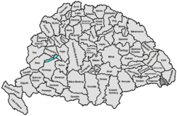
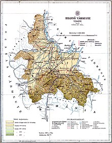
The Kronstadt County ( Hungarian Brassó vármegye , Romanian Comitatul Brașov ) was an administrative unit ( county or county ) of the Kingdom of Hungary . Today the area is in Transylvania in Romania .
location
It bordered on the counties Groß-Kokelburg (Nagy-Küküllő) , Háromszék , Fogaras and in the south on the Kingdom of Romania .
The German name is derived from the main town of the county - Kronstadt (now Brașov ).
geography
The county is quite flat in the north, the so-called Burzenland , but very mountainous in the south ( Bucegi Mountains , Piatra Mare Mountains ). The Alt (now Romanian Olt ) flows through the country and, together with its tributaries, creates a very fertile land. Of all the counties in eastern Hungary, Kronstadt was the economically strongest area.
history
The Kronstadt County was established in 1876 when the Kronstadt district , which previously existed in the Grand Duchy of Transylvania , was dissolved and the borders were redefined.
After the end of the First World War in 1918, the area came to Greater Romania as a result of the Treaty of Trianon and initially continued to exist here as a Jewț (district) Brașov. After an administrative reform in 1950, the area belonged to the Brașov region and, after the return to the principle of the Jews, also became part of the present Brașov district .
District subdivision
In the early 20th century, the county consisted of the following chair districts (named after the name of the administrative center):
| Chair districts (járások) | |
|---|---|
| Chair district | Administrative headquarters |
| Alvidék ("Unterland") | Földvár, today Feldioara |
| Felvidék ("Oberland") | Brassó, today Brașov , previously Feketehalom, today Codlea |
| Hétfalus ("Seven Villages") | Hosszúfalu / Satulung, today part of Săcele |
| City district (rendezett tanácsú város) | |
| Brassó, today Brașov | |
All places are in today's Romania .
See also
literature
- Kronstadt . In: Meyers Konversations-Lexikon . 4th edition. Volume 10, Verlag des Bibliographisches Institut, Leipzig / Vienna 1885–1892, pp. 252–253.
Web links
- Entry in the Pallas Lexicon (Hungarian)
Individual evidence
- ↑ A magyar szent corona országainak 1910. évi népszámlálása . Budapest 1912, p. 12 ff.
- ↑ A magyar szent corona országainak 1910. évi népszámlálása . Budapest 1912, p. 22 ff. (1910 census)

