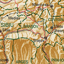
Brasov County


Brașov ([ braˈʃov ]; ) is a Romanian district (Județ) in the Transylvania region with the district capital Brașov ( German Kronstadt , Hungarian Brassó ). Its common abbreviation and license plate are BV.
The Braşov County borders in the north to the counties Mures and Harghita , in the east to the Covasna County , in the south to the counties of Prahova , Dambovita and Arges and in the west to the Sibiu county .
Demographics
In 2002 the district had 588,366 inhabitants and a population density of 110 inhabitants per km². In addition to Romanians, who make up the main population, there are still German-speaking and Hungarian -speaking parts of the population.
In 2011, the Brașov district had 549,217 inhabitants, a population density of around 102 inhabitants per km².
geography
Waters
The main river is the Olt (Alt) , which crosses the Brașov district over a length of 210 kilometers. Its tributaries are: Baraolt, Vârghiş , Aita, Homorodul Vechi, Valea Mare, Râul Negru , Timiş, Bârsa , Ghimbăşel , Șinca, Sâmbăta, Vulcănița, Sebeş , Berivoiul, Breaza, Viştea and Rodbav.
climate
The climate is continentally cool and wet in the mountain areas with relatively little rainfall and slightly higher temperatures in the lower areas.
The lowest temperature in Romania was registered on January 25, 1942 in the municipality of Bod (Brenndorf) at −38.5 ° C. The winds often reach up to 25-30 m / s in the peaks of the mountains . The prevailing wind direction is west.
Landscapes
The Brașov County has a total area of 5363 km², which corresponds to 2.2% of the area of Romania. Its heathland is hilly and rises from north to south in the sea level. In the middle, valley landscapes dominate, separated by the Perșani Mountains (ghost forest) . In the north-west lies a part of the Harbach highlands . In the south rise the Fagaras Mountains , the Bucegi Mountains (Butschetsch Mountains) , the Piatra Craiului Mountains (Königstein) , the Postăvarul Mountains (Schuler) , the Piatra Mare Mountains (Hohenstein) and the Ciucaș Mountains (Crow's stone) .
On the summit of Omul in the Bucegi Mountains (Munții Bucegi) , the lowest annual temperatures are measured with an average of −2.6 ° C; the highest annual rainfall in the district averages 1346 mm and the average annual temperature of the Brasov district is 8 ° C.
cities and communes
Status of the localities
The Brașov County officially consists of 166 localities. 10 of these have the status of a city, 48 that of a municipality and the rest are administratively assigned to cities and municipalities.
Largest towns in Brașov County
| City / municipality | Residents |
|---|---|
| Brașov ( German Kronstadt , Hungarian Brassó ) | 253.200 |
| Săcele (dt. Seven villages , ung. Szecseleváros ) | 30,798 |
| Făgăraș (German Fogarasch , Hungarian Fogaras ) | 30,714 |
| Zărneşti (German Zernescht , Hungarian Zernest ) | 23,476 |
| Codlea (German Zeiden , Hungarian Feketehalom ) | 21,708 |
| Râșnov (German Rosenau , Hungarian Barcarozsnyó ) | 15,022 |
| Victoria (German Viktoriastadt , Hungarian Győzelemváros ) | 7,386 |
| Prejmer (German Tartlau , Hungarian Prazsmar ) | 8,472 |
| Tărlungeni (German Tatrang ) | 8,320 |
| Feldioara (German Marienburg , Hungarian Földvár ) | 6.154 |
| Hărman (German Honigberg , Hungarian Hermány ) | 5,402 |
| Rupea (German Reps , Hungarian Köhalom ) | 5,269 |
| Bran (German Törzburg , Hungarian Törcsvár ) | 5,181 |
| Hoghiz (German hot water , Hungarian Olthévíz ) | 5,025 |
| Moieciu (German Moesch , Hungarian Alsómoécs ) | 4,892 |
| Predeal (Hungarian Predeál ) | 4,755 |
| Ghimbav (German Weidenbach , Hungarian Vidombák ) | 4,698 |
| Vulcan (German Wolkendorf , Hungarian Szászvolkány ) | 4,567 |
| Cristian (German New Town , Hungarian Keresztényfalva ) | 4,457 |
| (As of October 20, 2011) | |
See also
Web links
Individual evidence
- ↑ a b 2011 census in Romania ( MS Excel ; 1.3 MB)


