
Vârghiș
|
Vârghiș Vargyas |
|||||
|
|||||
| Basic data | |||||
|---|---|---|---|---|---|
| State : |
|
||||
| Historical region : | Transylvania | ||||
| Circle : | Covasna | ||||
| Coordinates : | 46 ° 8 ′ N , 25 ° 33 ′ E | ||||
| Time zone : | EET ( UTC +2) | ||||
| Height : | 498 m | ||||
| Area : | 70.24 km² | ||||
| Residents : | 1,647 (October 20, 2011) | ||||
| Population density : | 23 inhabitants per km² | ||||
| Postal code : | 527180 | ||||
| Telephone code : | (+40) 02 67 | ||||
| License plate : | CV | ||||
| Structure and administration (as of 2016) | |||||
| Community type : | local community | ||||
| Structure : | Vârghiș | ||||
| Mayor : | Sütő Levente-Lehel (independent) | ||||
| Postal address : | Str. Pricipală nr. 423 loc. Vârghiș, jud. Covasna, RO-527180 |
||||
| Website : | |||||


Vârghiș old spelling Vîrghiș [ ˈvɨrɟiʃ ] ( Hungarian Vargyas ) is a municipality in the Covasna County , in the Transylvania region in Romania .
The place is also known by the Romanian outdated names Varghiaș and Vărghiș .
Geographical location

The place Vârghiş is located in the northeastern foothills of the Perşani Mountains (Munții Perşani) in the historic Szeklerland . In the northwest of the Covasna district on the creek of the same name, a right tributary of the Cormoș , and the district road (Drum județean) DJ 131, Vârghiș is nine kilometers north of the small town of Baraolt and about 65 kilometers north of the district capital Sfântu Gheorghe (Sankt Georgen) .
history
The village of Vârghiș, mostly inhabited by Szeklern people, was first mentioned in a document in 1334 and is now a well-known wood carving center.
The archaeological find of an earth wall fixed with stones in the municipality, along the Rika mountain in a north-south direction, indicates a settlement in the second half of the 1st century.
At the time of the Kingdom of Hungary , today's place belonged to the Homoród district in Udvarhely County (Oderhellen County) , then to the historical Odorhei district and then to today's Covasna district.
Since the wooden church built in 1807 in Vârghiş was too small for the number of the Romanian population of the place, a new church in the Byzantine style was built in two years from 1935 . After Northern Transylvania was awarded Hungary in the Second Vienna Arbitration , the Romanian Orthodox population of the place was forced to accept the Reformed denomination and their church was destroyed. The iconostasis of the church was saved and is now in the museum in Sfântu Gheorghe. In place of the Orthodox Church, consecrated in 1937, a marble cross with a picture of the church was erected next to today's primary school.
There is an open pit mine for the extraction of lignite on the site .
population
The population of the municipality of Vârghiş developed as follows:
| census | Ethnic composition | ||||
|---|---|---|---|---|---|
| year | population | Romanians | Hungary | German | other |
| 1850 | 1,474 | 156 | 1,200 | - | 118 |
| 1941 | 2,088 | 10 | 2,077 | 1 | - |
| 1966 | 2,218 | 155 | 2,026 | - | 37 |
| 2002 | 1,902 | 36 | 1,862 | 1 | 3 |
| 2011 | 1,647 | 10 | 1,612 | - | 25th |
Since 1850, Vârghiş had its highest population in 1966. The highest number of Magyars was registered in 1941 by Romanians (268) in 1920, that of Roma (168) in 1930 and that of Romanian Germans (8) in 1880.
Attractions
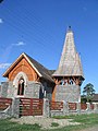
- The wooden church Sf. Arhangheli Mihail și Gavril in 1807 and the wooden bell tower built in the 19th century are listed buildings.
- According to the Directory of Historical Monuments of the Ministry of Culture and National Heritage (Ministerul Culturii și Patrimoniului Național) , several properties in Vârghiș are listed. These are property No. 80 built in the 18th century, property No. 99 1773, property No. 106 1873, No. 348 1868, at property No. 396 the wooden house built in 1879 and its entrance gate in 1910, and others six properties from the 18th / 19th century Century are under monument protection.
- The manor house of the Hungarian noble family Daniel built in the 16th century and rebuilt several times is a listed building.
- The place Vârghiș is also the starting point for the gorge of the same name, the Cheile Vârghișului nature reserve with its numerous caves . One of the most famous caves is the Mereşti Cave .

Wooden church

View of Vârghiș

Unitarian Church
reformed Church


Town twinning
Vârghiș has partnerships with the Hungarian municipalities of Vésztő , Pápakovácsi and Szabadszállás .
Web links
Individual evidence
- ↑ 2011 census in Romania ( MS Excel ; 1.3 MB).
- ↑ Arcanum Kézikönyvtár: Historical-administrative book of place names of Transylvania, Banat and Partium. Retrieved November 20, 2019 (Hungarian).
- ↑ a b Heinz Heltmann, Gustav Servatius (Ed.): Travel Guide Siebenbürgen . Kraft, Würzburg 1993, ISBN 3-8083-2019-2 , p. 517 .
- ↑ Institute Of Archeology - Varghis , accessed on November 23, 2019 (Romanian).
- ↑ The Marble Cross on Street View - accessed July 2012 on November 23, 2019
- ^ Adrian Nicolae Petcu: Biserica dispărută a românilor din Vârghiș-Covasna. Ziarul Lumina, September 5, 2011, accessed November 23, 2019 (Romanian).
- ↑ Censuses 1850–2002, last updated November 2, 2008 (PDF; 1 MB; Hungarian).
- ↑ Information on the wooden church in Vârghiș at biserici.org, accessed on November 23, 2019 (Romanian).
- ↑ a b c List of historical monuments of the Romanian Ministry of Culture , updated 2015 (PDF; 12.7 MB; Romanian).
- ↑ Daniel Castle, Vargyas. Castle in Transylvania, accessed November 23, 2019 (English, Hungarian, Romanian).
- ↑ Cheile Vârghișului at protectedplanet.net , accessed on November 23, 2019 (English)
- ↑ Information on the Cheile Vârghișului gorge on the website of the municipality
- ↑ Information on the Cheile Vârghișului gorge at turism-transilvania.ro , accessed on November 23, 2019 (English, Romanian)
Aita Mare | Arcuș | Barcani | Bățani | Belin | Bixad | Bodoc | Boroșneu Mare | Brateș | Brăduț | Brețcu | Catalina | Cernat | Chichiș | Comandău | Dalnic | Dobârlău | Estelnic | Ghelința | Ghidfalău | Hăghig | Ilieni | Lemnia | Malnaș | Mereni | Micfalau | Moacșa | Ojdula | Ozun | Poian | Reci | Sânzieni | Sita Buzăului | Turia | Valea Crișului | Valea Mare | Vâlcele | Vârghiș | Zagon | Zabala