
Mereni (Covasna)
|
Mereni Kézdialmás |
|||||
|
|||||
| Basic data | |||||
|---|---|---|---|---|---|
| State : |
|
||||
| Historical region : | Transylvania | ||||
| Circle : | Covasna | ||||
| Coordinates : | 46 ° 5 ' N , 26 ° 14' E | ||||
| Time zone : | EET ( UTC +2) | ||||
| Height : | 607 m | ||||
| Area : | 51.96 km² | ||||
| Residents : | 1,324 (October 20, 2011) | ||||
| Population density : | 25 inhabitants per km² | ||||
| Postal code : | 527112 | ||||
| Telephone code : | (+40) 02 67 | ||||
| License plate : | CV | ||||
| Structure and administration (as of 2016) | |||||
| Community type : | local community | ||||
| Structure : | Mereni, Lutoasa | ||||
| Mayor : | István Molnár ( UDMR ) | ||||
| Postal address : | Str. Principală, no. 250 loc. Mereni, jud. Covasna, RO-527112 |
||||
| Website : | |||||
| Others | |||||
| City Festival : | 2nd Sunday in August "community festival" | ||||


Mereni [ ˈmerenʲ ] (outdated Almaș ; Hungarian Kézdialmás or Almás ) is a municipality in Covasna County , in the Transylvania region in Romania .
Geographical location

The municipality of Mereni is located north of the Kronstadt depression (Depresiunea Brașovului) in the southern foothills of the Nemira Mountains (Munții Nemira) , a part of the Eastern Carpathians . In the so-called Szeklerland , in the north of the Covasna district, the place Mereni is located on the Târgu Secuiesc – Brețcu railway and the district road (Drum județean) DJ 114, 16 kilometers north of the small town of Târgu Secuiesc (Szekler Neumarkt) and about 50 kilometers northeast of the district capital Sfântu Gheorghe (Sankt Georgen) away.
history
Mereni, which is mostly inhabited by Szeklers , was first mentioned in a document in 1567. At the same time, eleven properties were recorded in the community center and six in the incorporated village of Lutoasa (Thomoren) .
According to the directory of historical monuments of the Ministry of Culture and National Heritage (Ministerul Culturii și Patrimoniului Național) , on the right bank of the Lemnia Mică stream ( Varpataka in Hungarian ), the area called Cetatea Ciuchian ( Csuklyán in Hungarian ) of the incorporated village of Lutoasa by the locals , Remains of a castle from the Bronze Age assigned to the Wietenberg culture.
In 1602 17 households are recorded in Mereni, of which seven were aristocratic families, nine free farmers and one family were serfs . A hundred years later, 58 households, including four nobles, 17 serfs and six very poor farming families, are recorded. Since Mereni was close to the Austro-Hungarian border with the Principality of Moldova , in 1802 of the 78 families registered in the village, the men of 52 families, were active in the border guards.
At the beginning of the 20th century, in 1904, the railway line from Târgu Secuiesc to Brețcu was completed in the municipality. In World War I the place Mereni 36 and has World War II to mourn 43 dead. After the collectivization of agriculture , the villagers began to leave the place and settled in the nearby town of Târgu Secuiesc.
At the time of the Kingdom of Hungary Poian belonged to the Kézdi chair district in the Háromszék County ( Romanian Comitatul Trei-Scaune ). Subsequently, Mereni belonged to the historical Trei-Scaune (German three chairs ) and from 1950 to today's Covasna district. Administratively, the villages Mereni and Lutoasa belonged to today's municipality of Lemnia until 2004 . On the hill called Sfântul Mihail ( 633 m ), between the villages of Mereni and Lemnia, both places once built the church of the same name together. Since both places also have their own churches, this is only used for special events and funerals.
population
The population of the two places of today's municipality developed as follows:
| census | Ethnic composition | ||||
|---|---|---|---|---|---|
| year | population | Romanians | Hungary | German | other |
| 1850 | 1,623 | - | 1,623 | - | - |
| 1930 | 1,893 | 3 | 1,876 | 1 | 13 |
| 1977 | 1,715 | 7th | 1,708 | - | - |
| 2002 | 1,410 | 9 | 1,390 | - | 11 |
| 2011 | 1,324 | 18th | 1,280 | - | 26th |
The highest number of inhabitants (2,254) and that of the Magyars (2,254) in 1920 were determined in the area of today's municipality since 1850. The highest number of Romanians was registered in 2011, that of Roma (21) in 1941 and that of Romanian Germans one each in 1930 and 1992.
Attractions
- On the hill of Sfântul Mihail, the Roman Catholic church of the same name , rebuilt in the Baroque style around 1777, is surrounded by an oval defensive wall about 80 centimeters thick and four meters high. There are three bells in the bell tower. The initials of the Kronstadt bell-founder Heinrich Lampe and the year "H." are written on the oldest and also the smallest bell, weighing around 100 kilograms . L. 1697 ” and in Latin “ O Rex glorie Iesu Criste veni cum eterna pace cura me Lenhemnyense ” . The bells, which weigh around 600 and 1000 kilograms, were cast by Fritz Kauntz in Sibiu in 1926 .

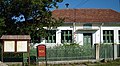
Village center and the Roman Catholic Church in Mereni

Old school in Mereni (demolished in 2007)

Castle wall of the Catholic Church on the Michaelsberg

Roman Catholic Church in Lutoasa
School in Lutoasa


Personalities
- Didák Kelemen (1683–1744) was a provincial governor and Minorite priest.
- Frigyes Kelemen (1924-1979), was a Hungarian physicist and taught mechanics and thermodynamics at the Babeş-Bolyai University in Cluj in Hungarian.
Town twinning
Mereni maintains a partnership with the Hungarian towns of Szihalom and Püspökszilágy .
Web links
Individual evidence
- ↑ 2011 census in Romania ( MS Excel ; 1.3 MB).
- ↑ Arcanum Kézikönyvtár: Historical-administrative book of place names of Transylvania, Banat and Partium. Retrieved April 3, 2020 (Hungarian).
- ↑ Heinz Heltmann, Gustav Servatius (Ed.): Travel Guide Siebenbürgen . Kraft, Würzburg 1993, ISBN 3-8083-2019-2 , p. 517 .
- ↑ a b c d e Information on the municipality of Mereni on their website , accessed on April 3, 2020 (Romanian).
- ↑ List of historical monuments of the Romanian Ministry of Culture , updated 2015 (PDF; 12.7 MB; Romanian).
- ↑ Information from the Senate meeting on February 12, 2004 , accessed on April 3, 2020 (Romanian).
- ↑ Censuses 1850–2002, last updated November 2, 2008 (PDF; 1 MB; Hungarian).
- ↑ Information on the church of Sfântul Mihail and a 360 ° view, accessed on April 4, 2020 (Romanian).
- ↑ Information on Didák Kelemen at archiv.katolikus.hu, accessed on April 4, 2020 (Hungarian).
- ↑ Information on Frigyes Kelemen at mek.oszk.hu, accessed on April 4, 2020 (Hungarian).
- ↑ Information on the website of the Mereni municipality accessed on April 3, 2020 (Romanian).
Aita Mare | Arcuș | Barcani | Bățani | Belin | Bixad | Bodoc | Boroșneu Mare | Brateș | Brăduț | Brețcu | Catalina | Cernat | Chichiș | Comandău | Dalnic | Dobârlău | Estelnic | Ghelința | Ghidfalău | Hăghig | Ilieni | Lemnia | Malnaș | Mereni | Micfalau | Moacșa | Ojdula | Ozun | Poian | Reci | Sânzieni | Sita Buzăului | Turia | Valea Crișului | Valea Mare | Vâlcele | Vârghiș | Zagon | Zabala