
Ilieni (Covasna)
|
Ilieni Ilgendorf Illyefalva |
|||||
|
|||||
| Basic data | |||||
|---|---|---|---|---|---|
| State : |
|
||||
| Historical region : | Transylvania | ||||
| Circle : | Covasna | ||||
| Coordinates : | 45 ° 48 ' N , 25 ° 46' E | ||||
| Time zone : | EET ( UTC +2) | ||||
| Height : | 534 m | ||||
| Area : | 60.00 km² | ||||
| Residents : | 2,036 (October 20, 2011) | ||||
| Population density : | 34 inhabitants per km² | ||||
| Postal code : | 527105 | ||||
| Telephone code : | (+40) 02 67 | ||||
| License plate : | CV | ||||
| Structure and administration (as of 2016) | |||||
| Community type : | local community | ||||
| Structure : | Ilieni, Dobolii de Jos , Sâncraiu | ||||
| Mayor : | Imre Fodor ( UDMR ) | ||||
| Postal address : | St. Kossuth Lajos, no. 97 loc. Ilieni, jud. Covasna, RO-527105 |
||||
| Website : | |||||


Ilieni [ iliˈenʲ ] (outdated Ileni or Ilefalva ; German Ilgendorf , Hungarian Illyefalva ) is a municipality in the Covasna district , in the Transylvania region in Romania .
The place Ileni is also known under the German name Eliasdorf and the Transylvanian-Saxon name Ilschendref .
Geographical location

The municipality of Ilieni is located in the Kronstadt depression (Depresiunea Brașovului) , in the southern foothills of the Baraolter Mountains north of the historic Burzenland . In the historical region of Szeklerland in the southwest of the Covasna district, the town of Ilieni is located on the stream of the same name - a right tributary of the Olt (Alt) - and on the district road (drum județean) DJ 112 nine kilometers south of the district capital Sfântu Gheorghe (Sankt Georgen) away.
The nearest train station is in the district capital on the Brașov – Sfântu Gheorghe – Târgu Secuiesc railway line .
history
Ilieni, which is mostly inhabited by Szeklern people, was first mentioned in a document in 1332. According to Ferenc László 1910, the creek Ilieni were west of Ilieni on the left bank archaeological discoveries made which called for a settlement of the area, the locals Dealul Izvorului (Hungarian Forrásdomb ) below the summit Vârful Taiat , in the Neolithic indicate . At Dealul Izvorului (Hungarian Forrásdomb ), also west of the place Ilieni on the stream of the same name, finds indicate a settlement in Roman times . Several finds from different ages were made at the Agriș (Egrespatak) brook and are in the museum of the district capital.
In the area of the incorporated village Dobolii de Jos (Hungarian Aldoboly ) on the banks of the Olt, on the area called Mândra (Hungarian Büszke ), cremation graves point to the Hallstatt period and numerous finds from the Neolithic, Iron Age and Latency periods , and are also in the museum the district capital Sfântu Gheorghe.
In the incorporated village of Sâncraiu (Hungarian Szentkirály ) near Culmea Lagului (Hungarian Lagteteje ), Márton Roska noted the occurrence of the volcanic rock obsidian in 1934 . These finds are also in the museum of Sfântu Gheorghe.
At the time of the Kingdom of Hungary Ilieni belonged to the chair district Miklósvár in the County Háromszék ( Romanian Comitatul Trei-Scaune ), then the historic district Trei-Scaune (German Three chairs ) and from 1950 to today's county Covasna.
population
The population of the Ilieni municipality developed as follows:
| census | Ethnic composition | ||||
|---|---|---|---|---|---|
| year | population | Romanians | Hungary | German | other |
| 1850 | 2,854 | 654 | 2,097 | 7th | 96 |
| 1920 | 3,332 | 1,144 | 2.159 | 15th | 14th |
| 1966 | 2,571 | 286 | 2,275 | 9 | 1 |
| 2002 | 1,853 | 237 | 1,610 | 6th | - |
| 2011 | 2,036 | 253 | 1,749 | 4th | 34 |
Since 1850 the highest number of inhabitants and at the same time that of the Romanians and Romanian Germans in 1920 have been determined in the area of the municipality of Ilieni. The highest number of Magyars (2,786) was registered in 1880 and that of Roma (96) in 1850.
Attractions
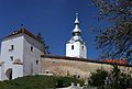
- In the community center, the fortress was, according to the Register of Historic Monuments of the Ministry of Culture and National Heritage (Ministerul Culturii şi Patrimoniului Naţional) built in the 15th century and renovated in the 18th century, the Calvinist church built from 1782 to 1786, the bell tower in the 18th Built in the 19th century and the rectory built in the 19th century, are listed.
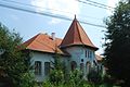
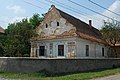
- In Ilieni, the Bakó (built in 1793), Bornemissza (built in the 18th century) and Séra (built in 1811) country houses are listed buildings.
- In the incorporated village of Dobolii de Jos, the country house of the Hungarian aristocratic family Reznek (Czaker) , built between 1790 and 1813, and the Hollaky country house , built in 1718 and renovated in 1806, are listed as historical monuments.
- In the incorporated village of Sâncraiu, the Unitarian church built in the 15th century and rebuilt in the 18th century is a listed building and the reformed church was built around 1879.
town hall
Bell tower ...

and church ...

the fortified castle in Ilieni

Country house Séra
Bakó country house

Roman Catholic Church in Ilieni

Orthodox Church in Dobolii de Jos

Reformed Church in Sâncraiu

.jpg)

.jpg)


Web links
Individual evidence
- ↑ 2011 census in Romania ( MS Excel ; 1.3 MB).
- ↑ Arcanum Kézikönyvtár: Historical-administrative book of place names of Transylvania, Banat and Partium. Retrieved November 12, 2019 (Hungarian).
- ↑ Heinz Heltmann, Gustav Servatius (Ed.): Travel Guide Siebenbürgen . Kraft, Würzburg 1993, ISBN 3-8083-2019-2 , p. 517 .
- ↑ Institute Of Archeology - Ilieni , accessed on July 1, 2020 (Romanian).
- ↑ Institute Of Archeology - Dobolii de Jos , accessed July 1, 2020 (Romanian).
- ^ Institute Of Archeology - Sâncraiu , accessed July 1, 2020 (Romanian).
- ↑ Censuses 1850–2002, last updated November 2, 2008 (PDF; 1 MB; Hungarian).
- ↑ Information on the Reformed Church in Ilieni at biserici.org, accessed on July 1, 2020 (Romanian).
- ↑ a b c d List of historical monuments of the Romanian Ministry of Culture , updated 2015 (PDF; 12.7 MB; Romanian).
- ↑ Information on Landhaus Bakó at castleintransylvania.ro, accessed on July 1, 2020 (English, Romanian, Hungarian)
- ↑ Information on the Bornemissza country house at monumenteuitate.org, accessed on July 1, 2020 (English, Romanian).
- ↑ Information on Landhaus Séra at castleintransylvania.ro, accessed on July 1, 2020 (English, Romanian, Hungarian)
- ↑ Information on Landhaus Reznek at monumenteuitate.org, accessed on July 1, 2020 (English, Romanian).
- ↑ Information on Landhaus Hollaky at castleintransylvania.ro, accessed on July 1, 2020 (English, Romanian, Hungarian)
- ↑ 360 ° view of the fortified church in Sâncraiu
- ↑ Information on the Reformed Church in Sâncraiu at biserici.org, accessed on June 1, 2020 (Romanian).
Aita Mare | Arcuș | Barcani | Bățani | Belin | Bixad | Bodoc | Boroșneu Mare | Brateș | Brăduț | Brețcu | Catalina | Cernat | Chichiș | Comandău | Dalnic | Dobârlău | Estelnic | Ghelința | Ghidfalău | Hăghig | Ilieni | Lemnia | Malnaș | Mereni | Micfalau | Moacșa | Ojdula | Ozun | Poian | Reci | Sânzieni | Sita Buzăului | Turia | Valea Crișului | Valea Mare | Vâlcele | Vârghiș | Zagon | Zabala