
Olt (river)
|
Olt Alt |
||
 Course of the Olt in Romania |
||
| Data | ||
| location | Districts of Harghita , Covasna , Brașov , Sibiu , Vâlcea , Olt , Teleorman ( Romania ) | |
| River system | Danube | |
| Drain over | Danube → Black Sea | |
| source | near Bălan ( Hăşmaşu Mare Mountains in the Eastern Carpathians ) 46 ° 44 ′ 32 ″ N , 25 ° 44 ′ 38 ″ E |
|
| Source height | 1280 m | |
| muzzle | 5 km west of Turnu Măgurele in the Danube Coordinates: 43 ° 42 ′ 46 " N , 24 ° 47 ′ 45" E, 43 ° 42 ′ 46 " N , 24 ° 47 ′ 45" E |
|
| Mouth height | 21 m | |
| Height difference | 1259 m | |
| Bottom slope | 2 ‰ | |
| length | 615 km | |
| Catchment area | 24,010 km² | |
| Drain |
MQ |
190 m³ / s |
| Left tributaries | Râul Negru , Bârsa , Topolog , Racovița | |
| Right tributaries | Vârghiș , Homorod , Cibin , Lotru , Olteț , Teslui | |
| Reservoirs flowed through | Barajul Mesteacănul | |
| Big cities | Râmnicu Vâlcea | |
| Medium-sized cities | Miercurea Ciuc , Sfântu Gheorghe , Făgăraș , Slatina | |
| Small towns | Bălan , Drăgăneşti-Olt | |
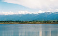
 The Olt in the Southern Carpathians |
||
The Olt ( German old ; Hungarian Olt ; from Latin lut = clay, Roman aluta ) is a left tributary of the Danube in Romania with a length of 615 kilometers. Shortly before it flows into the Danube, the river reaches a water flow of 190 m³ / s. He is also the namesake of the Romanian district of Olt .
The Olt flows entirely on Romanian territory. It rises in the Eastern Carpathians flows in a southerly direction to Bod (Brenndorf) , where he makes a bow and Perşani Mountains crossed, then the historic west Altland in the region Transylvania flows and leaves Transylvania in a southerly direction, crossing the Red Tower Pass the Transylvanian Alps towards Getische Plateau or Wallachia , where it flows into the Danube in the extreme south of the country five kilometers west of Turnu Măgurele .
In Transylvania are the villages of Hărman (Honigberg) , Bod, Feldioara (Marienburg) , Șercaia (Schirkanyen) , Cincșor (Kleinschenk) , Făgăraș (Fogarasch) , Cârța (Kerz) , Avrig (Freck) and Tălmaciu (Talmesch) am Olt.
At Talmaciu the right tributary Cibin flows into the Olt, before it changes direction again and crosses the Southern Carpathians through the Rotenturm Pass in a southerly direction.
Economical meaning
The river is dammed on a total of 24 barrages that were built for the purpose of generating electricity. The first is near Făgăraş. The length of the reservoirs varies and generally gets longer towards the mouth. Most of the lakes are enclosed by a wall. The dams with the power plants are all of the same type. Shipping was carried out on the river until the 19th century.
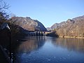
Reservoir near Avrig

The Olt at the Red Tower Pass
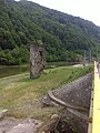
Half tower (Turnul Spart) at Boița

Racovița hydropower plant

Cozia Monastery near Călimăneşti
Hydroelectric power station near Călimăneşti

Bridge at Râmnicu Vâlcea

Bridge at Slatina


.jpg)


Web links
- Article Olt in the Great Soviet Encyclopedia (BSE) , 3rd edition 1969–1978 (Russian)
- Wilhelm Tomaschek : Alutas . In: Paulys Realencyclopadie der classischen Antiquity Science (RE). Volume I, 2, Stuttgart 1894, column 1707.