Turia (Covasna)
|
Turia Torja |
||||
|
||||
| Basic data | ||||
|---|---|---|---|---|
| State : |
|
|||
| Historical region : | Transylvania | |||
| Circle : | Covasna | |||
| Coordinates : | 46 ° 2 ' N , 26 ° 3' E | |||
| Time zone : | EET ( UTC +2) | |||
| Height : | 599 m | |||
| Area : | 147.17 km² | |||
| Residents : | 4,027 (October 20, 2011) | |||
| Population density : | 27 inhabitants per km² | |||
| Postal code : | 527160 | |||
| Telephone code : | (+40) 02 67 | |||
| License plate : | CV | |||
| Structure and administration (as of 2016) | ||||
| Community type : | local community | |||
| Structure : | Turia, Alungeni | |||
| Mayor : | Attila Dărăguș ( UDMR ) | |||
| Postal address : | Str. Principală, no. 835 loc. Turia, jud. Covasna, RO-527160 |
|||
| Website : | ||||
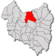
Turia ( Hungarian Torja ) is a municipality in the Covasna district in the Transylvania region , Romania .
Geographical location
The place Turia is located ten kilometers northwest of the small town of Târgu Secuiesc and about 50 kilometers northeast of the district capital Sfântu Gheorghe . In 2011 the community had 4027 inhabitants, 3959 were Hungarians and 43 known themselves as Romanians .
The city belonged to Hungary until 1918 and since then to Romania.
Web links
Commons : Turia - collection of images, videos and audio files
Individual evidence
- ↑ 2011 census in Romania ( MS Excel ; 1.3 MB)


