
Brateș (Covasna)
|
Brateș monks' village Baratos |
|||||
|
|||||
| Basic data | |||||
|---|---|---|---|---|---|
| State : |
|
||||
| Historical region : | Transylvania | ||||
| Circle : | Covasna | ||||
| Coordinates : | 45 ° 50 ' N , 26 ° 4' E | ||||
| Time zone : | EET ( UTC +2) | ||||
| Height : | 529 m | ||||
| Area : | 33.92 km² | ||||
| Residents : | 1,531 (October 20, 2011) | ||||
| Population density : | 45 inhabitants per km² | ||||
| Postal code : | 527050 | ||||
| Telephone code : | (+40) 02 67 | ||||
| License plate : | CV | ||||
| Structure and administration (as of 2016) | |||||
| Community type : | local community | ||||
| Structure : | Brateș, Pachia , Telechia | ||||
| Mayor : | Ferenc-Szabolcs Tánczos ( UDMR ) | ||||
| Postal address : | Str. Principală nr. 61 loc. Brateș, jud. Covasna, RO-527050 |
||||
| Website : | |||||


Brateș [ ˈbrateʃ ] ( German monk village , Hungarian Barátos ) is a municipality in the Covasna district , in the Transylvania region in Romania .
Geographical location

The municipality of Brateș is located north of the Întorsura Mountains , a part of the Eastern Carpathian Mountains . On the Covasna - a tributary of the Râul Negru -, the Drum național 13E and the Brașov – Sfântu Gheorghe – Târgu Secuiesc railway line, Brateș is ten kilometers west of the small town of Covasna and about 25 kilometers east of the district capital Sfântu Gheorghe (Sankt Georgen) away.
history
The place Brateş, which is mostly inhabited by Magyars, was first mentioned in a document in 1415.
In addition to the Covasna brook on the area known by the locals as Grădina lui Horváth ( Horváthkert in Hungarian ), remains of a substructure of a building from Roman times are assigned in Brateș. Several archaeological finds are also from Roman times, some could not be assigned to any era and are in the museum of the district capital.
At the time of the Kingdom of Hungary Brateş belonged to the Orbai chair district in the Háromszék County ( Romanian Comitatul Trei-Scaune ). Subsequently, Micfalău belonged to the historical Trei-Scaune (German three chairs ) and from 1950 to today's Covasna district.
population
The population of the municipality of Brateș developed as follows:
| census | Ethnic composition | ||||
|---|---|---|---|---|---|
| year | population | Romanians | Hungary | German | other |
| 1850 | 2,244 | 1 | 2.214 | 1 | 28 |
| 1910 | 2,787 | 121 | 2,622 | 4th | 40 |
| 1956 | 2,182 | 15th | 2.120 | - | 47 |
| 2002 | 1,548 | 16 | 1,532 | - | - |
| 2011 | 1,531 | 26th | 1,484 | - | 21st |
Since 1850, the highest number of inhabitants and that of the Magyars, Romanians and Romanian Germans in 1910 were determined in the area of the municipality of Brateș. The highest number of Roma (46) was registered in 1956.
Attractions
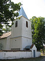
- In the community center, the Reformed Church , built in the 18th century, is a listed building according to the register of historical monuments of the Ministry of Culture and National Heritage (Ministerul Culturii și Patrimoniului Național) .
- In the incorporated village of Telechia (Grundsdorf), the property of the Hungarian aristocratic Horváth family , built in the 18th century, is a listed building.

Wood processing plant in Barátos (early 20th century)

Church in Brateș
Church in Pachia

Church in Telechia

Horváth country house (2006)


.jpg)
Web links
Individual evidence
- ↑ 2011 census in Romania ( MS Excel ; 1.3 MB).
- ↑ Heinz Heltmann, Gustav Servatius (Ed.): Travel Guide Siebenbürgen . Kraft, Würzburg 1993, ISBN 3-8083-2019-2 , p. 517 .
- ^ Institute Of Archeology - Brateș , accessed February 17, 2020 (Romanian).
- ↑ Censuses 1850–2002, last updated November 2, 2008 (PDF; 1 MB; Hungarian).
- ↑ a b List of historical monuments of the Romanian Ministry of Culture , updated 2015 (PDF; 12.7 MB; Romanian).
- ^ Image of the Horváth country house
Aita Mare | Arcuș | Barcani | Bățani | Belin | Bixad | Bodoc | Boroșneu Mare | Brateș | Brăduț | Brețcu | Catalina | Cernat | Chichiș | Comandău | Dalnic | Dobârlău | Estelnic | Ghelința | Ghidfalău | Hăghig | Ilieni | Lemnia | Malnaș | Mereni | Micfalau | Moacșa | Ojdula | Ozun | Poian | Reci | Sânzieni | Sita Buzăului | Turia | Valea Crișului | Valea Mare | Vâlcele | Vârghiș | Zagon | Zabala