
Moacșa
|
Moacșa Maksa |
|||||
|
|||||
| Basic data | |||||
|---|---|---|---|---|---|
| State : |
|
||||
| Historical region : | Transylvania | ||||
| Circle : | Covasna | ||||
| Coordinates : | 45 ° 52 ' N , 25 ° 58' E | ||||
| Time zone : | EET ( UTC +2) | ||||
| Height : | 547 m | ||||
| Area : | 32.82 km² | ||||
| Residents : | 1,201 (October 20, 2011) | ||||
| Population density : | 37 inhabitants per km² | ||||
| Postal code : | 527120 | ||||
| Telephone code : | (+40) 02 67 | ||||
| License plate : | CV | ||||
| Structure and administration (as of 2016) | |||||
| Community type : | local community | ||||
| Structure : | Moacșa, Pădureni | ||||
| Mayor : | János Deszke ( UDMR ) | ||||
| Postal address : | Str. Principală, no. 354 loc. Moacșa, jud. Covasna, RO-527120 |
||||
| Website : | |||||


Moacşa [ ˈmoakʃa ] (outdated Macşa or Mocşa ; Hungarian Maksa ) is a municipality in Covasna County , in the Transylvania region in Romania .
Geographical location

The municipality of Moacșa is located in the Kronstadt Depression (Depresiunea Brașovului) , in the southern foothills of the Bodoc Mountains (Munții Bodoc) - a part of the Eastern Carpathian Mountains . In the historical Szeklerland region in Covasna County, Moacşa is located on the Pădureni brook , a right tributary of the Râul Negru (Schwarzbach) , on the DN11 national road and the Brașov – Sfântu Gheorghe – Târgu Secuiesc railway , 15 kilometers east of the district capital Sfântu Gheorghe (Sankt Georgen) away.
history
The place Moacșa, mostly inhabited by Szeklern people, was first mentioned in a document in 1332. Two kilometers north of the town of Moacşa between the Ciubot and Nadaş streams , on the area called Vereşmort ( Veresmart in Hungarian ) by the locals , archaeological finds indicate that the town was settled in Roman times . The two round eight-meter-high earth walls with a circumference of 80 and 50 meters next to the Beșineu brook have not yet been assigned to an era. According to the register of historical monuments of the Ministry of Culture and National Heritage (Ministerul Culturii și Patrimoniului Național) in Moacșa near La Fântâna cu linte ( Lencsékút ⊙ in Hungarian ) a settlement in the Neolithic is noted. Here a 7 x 5 meter hut and a 1 x 1.20 m and 0.50 m high oven dug into the ground were found.
In the area of the incorporated village of Pădureni (Beschendorf) , on the areas known by the locals as Bobâlna (Hungarian Bábolna ) and Teleacul Mic (Hungarian Kistekelek ), finds indicate settlement in the Neolithic and Vârful lui Cente are found according to information from G Téglás of a Roman military camp noted. Numerous archaeological finds in the area of the village were the Neolithic, the Bronze Age , the Roman Age and many could not be assigned to any era. Most of the finds are in the museum in Sfântu Gheorghe.
At the time of the Kingdom of Hungary Moacşa belonged to the Kézdi chair district in the Háromszék County ( Romanian Comitatul Trei-Scaune ), then to the historical Trei-Scaune district (German three chairs ) and from 1950 to the present Covasna district.
When Dalnic was detached from what was then Moacşa in early 2004 , Moacşa and Pădureni became an independent community.
population
The population of today's Moacșa municipality developed as follows:
| census | Ethnic composition | ||||
|---|---|---|---|---|---|
| year | population | Romanians | Hungary | German | other |
| 1850 | 1,375 | 5 | 1,334 | 1 | 35 |
| 1941 | 1,661 | - | 1,629 | 4th | 28 |
| 2002 | 1,280 | 31 | 1,247 | - | 2 |
| 2011 | 1,201 | 27 | 1,123 | - | 51 |
Since 1850, the highest number of inhabitants and that of the Magyars in 1941 were determined in the area of today's Moacșa municipality. The highest number of Romanians (28) was registered in 1966, Romanian Germans (6) in 1956 and that of Roma (87) in 1966.
Attractions
- In the incorporated village of Pădureni, the reformed church built in the 15th century and rebuilt in the 19th century is a listed building.
- The country house of the Hungarian noble family Babós-Forró built in Pădureni in 1825 is a listed building.
- On the territory of the municipality the two kilometer long Moacşa-Pădureni reservoir was built in the 1980s.

Reformed Church in Moacșa

Reformed Church in Pădureni

Country house Babós-Forró
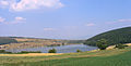
Moacșa-Pădureni reservoir


Web links
- The Moacșa municipality at ghidulprimariilor.ro
Individual evidence
- ↑ 2011 census in Romania ( MS Excel ; 1.3 MB).
- ↑ Heinz Heltmann, Gustav Servatius (Ed.): Travel Guide Siebenbürgen . Kraft, Würzburg 1993, ISBN 3-8083-2019-2 , p. 517 .
- ↑ Institute Of Archeology - Moacsa , accessed July 8, 2020 (Romanian).
- ↑ a b c List of historical monuments of the Romanian Ministry of Culture , updated 2015 (PDF; 12.7 MB; Romanian).
- ↑ Information on the archaeological find in Moacșa at La Fântâna cu linte , at ran.cimec.ro, accessed on July 7, 2020 (Romanian)
- ^ Institute Of Archeology - Pădureni , accessed July 8, 2020 (Romanian).
- ↑ Lege, privind înființarea comunei Dalnic, prin reorganizarea comunei Moacșa, județul Covasna. (PDF; 183 kB) Accessed July 5, 2020 (Romanian).
- ↑ Censuses 1850–2002, last updated November 2, 2008 (PDF; 1 MB; Hungarian).
- ↑ Information on the Reformed Church in Pădureni at biserici.org, accessed on June 8, 2020 (Romanian).
- ↑ Information on the country house Babós-Forró at monumenteuitate.org, accessed on July 8, 2020 (English, Romanian)
- ↑ Information and a 360 ° view of the Moacșa-Pădureni reservoir at virtualisszekelyfold.ro, accessed on July 8, 2020 (English, Romanian, Hungarian)
Aita Mare | Arcuș | Barcani | Bățani | Belin | Bixad | Bodoc | Boroșneu Mare | Brateș | Brăduț | Brețcu | Catalina | Cernat | Chichiș | Comandău | Dalnic | Dobârlău | Estelnic | Ghelința | Ghidfalău | Hăghig | Ilieni | Lemnia | Malnaș | Mereni | Micfalau | Moacșa | Ojdula | Ozun | Poian | Reci | Sânzieni | Sita Buzăului | Turia | Valea Crișului | Valea Mare | Vâlcele | Vârghiș | Zagon | Zabala