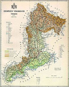
Semplin county
|
Semplin County (Zemplén) (1910) |
|
|---|---|

|
|
| Administrative headquarters : | Sátoraljaújhely |
| Area : | 6,282 km² |
| Population : | 343.194 |
| Ethnic groups : | 56% Magyars 27% Slovaks 11% Ruthenians 3% Germans |

|
|
The Zemplén County (German older and County Semmlin ; Hungarian vármegye Zemplén , Latin comitatus Zemplinum , Slovak Zemplínska župa / stolica ) is the name of a historic administrative unit (county / county) in the Kingdom of Hungary .
The area is now divided between eastern Slovakia and north-eastern Hungary , the Slovak name Zemplín is also used today as the unofficial name for this area and the official name of a tourist region.
location
Semplin County bordered on Poland in the north (or 1772-1918 on the Austrian crown land Galicia ), on the east on Ung County , on the south on Szabolcs County , in the extreme southwest on Borsod County , in the southwest on Abaúj-Torna County and in the north-west to Sáros County .
The area is located in the easternmost part of present-day Slovakia, except for an area between the Vihorlat Mountains and the Latorica , and a strip of land between the Bodrog and Tisza rivers in present-day Hungary . The Laborec and Bodrog rivers flow through the area. In 1910 there were 343,194 inhabitants in the county on an area of 6,282 km².
Administrative offices
Initially, the administrative seat was in the Semplin Castle (near Zemplín ), in the 13th century also in Sárospatak (Slovak [Blatný] Potok , hence the alternative name of the Comitatus de Potok county ). Since the late Middle Ages, the headquarters of the county was in Zemplín and from 1748 finally in Sátoraljaújhely .
history
As one of the oldest counties in the Kingdom of Hungary , it was probably founded around 1018, although the northern border at that time was the Latorica River . In the course of the following centuries, the more northern Slovak areas were gradually conquered by the Kingdom of Hungary and attached to the county. The later northern border (i.e. today's southern border of eastern Slovakia) was not reached until the beginning of the 14th century.
In the 17th century the county was around 1600, then 1622–1629 (see Gabriel Bethlen ) and shortly after 1645 part of Transylvania .
In 1918 the greater northern part of the region (including part of Ung County) became part of the newly formed Czechoslovakia , the southern part (with the town of Sátoraljaújhely ) remained as Zemplén County in Hungary , this was confirmed by the Treaty of Trianon in 1920.
From 1938 to 1945 the southern part of the former Czechoslovakian area of the former county was occupied by Hungary due to the First Vienna Arbitration Award, and in 1939, after the Hungarian-Slovak war , Hungary also occupied the eastern half of the remaining area of the former county. In Hungary the land came to the counties of Zemplén and Ung. In the first Slovak republic from 1940 to 1945 the newly founded Šarišsko-zemplínska župa (Sharosh-Zempliner County) existed.
After the end of World War II in 1945, the pre-war borders were restored. The Slovak County was dissolved. The Hungarian county of Zemplén was combined with the county of Borsod and part of the county of Abaúj-Torna to form the still existing county of Borsod-Abaúj-Zemplén .
Since 1993, when the Czech Republic and Slovakia separated peacefully, is the northern part of the landscape part of Slovakia and is located in Kosice (Košický kraj) and in the Prešov Region (Prešovský kraj).
The area of the county was incorporated into Czechoslovakia and Slovakia chronologically as follows:
- 1918–1922: Zemplínska župa (Semplin County), CS
- 1922–1928: Košická župa (Kosice County), CS
- 1928–1939: Slovenská krajina / zem (Slovak Land), CS
- 1940–1945: Šarišsko-zemplínska župa (Sharosh-Zemplin County), SK
- 1945–1948: Slovenská krajina (Slovak Country), CS
- 1949–1960: Prešovský kraj (Eperieser Landschaftsverband) + Košický kraj ( Košický kraj ( Košický kraj ( Košický kraj ) - both not to be confused with today's landscape associations, CS
- 1960–1990: Východoslovenský kraj (East Slovak Regional Association), CS
- since 1996: Prešovský kraj (Eperies Landscape Association) + Košický kraj (Kosice Landscape Association), SK
District subdivision
In the early 20th century, the county consisted of the following chair districts (mostly named after the name of the administrative seat):
| Chair districts (járások) | |
|---|---|
| Chair district | Administrative headquarters |
| Sátoraljaújhely | Sátoraljaújhely |
| Sárospatak | Sárospatak |
| Tokaj | Tokaj |
| Szerencs | Szerencs |
| Bodrogköz | Királyhelmec, today Kráľovský Chlmec |
| Nagymihály | Nagymihály, today Michalovce |
| Gálszécs | Gálszécs, today Sečovce |
| Varannó | Varannó, today Vranov nad Topľou |
| Sztropkó | Sztropkó, today Stropkov |
| Homonna | Homonna, today Humenné |
| Mezőlaborc | Mezőlaborc, today Medzilaborce |
| Szinna | Szinna, today Snina |
| City district (rendezett tanácsú város) | |
| Sátoraljaújhely | |
Sátoraljaújhely , Sárospatak , Tokaj and Szerencs are in present-day Hungary , the other places in present-day Slovakia .
See also
- List of traditional regions of Slovakia
- List of historical counties of Hungary
- Administrative division of Slovakia
- Zemplín (landscape)
literature
- Zemplin . In: Meyers Konversations-Lexikon . 4th edition. Volume 16, Verlag des Bibliographisches Institut, Leipzig / Vienna 1885–1892, p. 867.
Web links
- Entry in the Pallas Lexicon (Hungarian)
- History of the region (English)
Individual evidence
- ↑ A magyar szent corona országainak 1910. évi népszámlálása . Budapest 1912, p. 12 ff.
- ↑ A magyar szent corona országainak 1910. évi népszámlálása . Budapest 1912, p. 22 ff. (1910 census)


