
Stropkov
| Stropkov | |||
|---|---|---|---|
| coat of arms | map | ||

|
|
||
| Basic data | |||
| State : | Slovakia | ||
| Kraj : | Prešovský kraj | ||
| Okres : | Stropkov | ||
| Region : | Horný Zemplín | ||
| Area : | 24.674 km² | ||
| Residents : | 10,438 (Dec. 31, 2019) | ||
| Population density : | 423 inhabitants per km² | ||
| Height : | 202 m nm | ||
| Postal code : | 091 01 | ||
| Telephone code : | 0 54 | ||
| Geographic location : | 49 ° 12 ' N , 21 ° 39' E | ||
| License plate : | SP | ||
| Kód obce : | 527840 | ||
| structure | |||
| Community type : | city | ||
| Urban area structure: | 3 districts | ||
| Administration (as of November 2018) | |||
| Mayor : | Ondrej Brendza | ||
| Address: | Mestský úrad Stropkov Hlavná 38/2 09101 Stropkov |
||
| Website: | www.stropkov.sk | ||
| Statistics information on statistics.sk | |||

Stropkov (German Stroppkau , Hungarian Sztropkó ) is a city in eastern Slovakia .
It was first mentioned in writing as Stropko in 1404 ; uncertain sources often give the year 1245, but this has been scientifically refuted.
The city is divided into the parts Bokša (incorporated in 1964), Sitník and Stropkov.

Churches in Stropkov

Greek Catholic Church
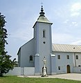
Church of the Franciscan Monastery


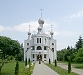
Orthodox Church

Gothic church


sons and daughters of the town
- Chananja Jom Tow Lipa Teitelbaum (1838–1904), Hasidic Chief Rabbi of Sziget
- Beáta Dubasová (* 1963), singer
- Ľuboš Micheľ (* 1968), football referee and manager
- Marek Špilár (1975-2013), football player
See also
Web links
Commons : Stropkov - collection of pictures, videos and audio files