Havaj
| Havaj | ||
|---|---|---|
| coat of arms | map | |

|
|
|
| Basic data | ||
| State : | Slovakia | |
| Kraj : | Prešovský kraj | |
| Okres : | Stropkov | |
| Region : | Horný Zemplín | |
| Area : | 14.258 km² | |
| Residents : | 399 (Dec. 31, 2019) | |
| Population density : | 28 inhabitants per km² | |
| Height : | 276 m nm | |
| Postal code : | 090 23 | |
| Telephone code : | 0 54 | |
| Geographic location : | 49 ° 15 ' N , 21 ° 47' E | |
| License plate : | SP | |
| Kód obce : | 527297 | |
| structure | ||
| Community type : | local community | |
| Administration (as of November 2018) | ||
| Mayor : | Stanislav Viňarský | |
| Address: | Obecný úrad Havaj č. 124 090 23 Havaj |
|
| Website: | www.obechavaj.sk | |
| Statistics information on statistics.sk | ||
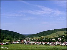
Havaj (Hungarian Havaj , Rusyn Гавай / Hawaj ) is a municipality in the north- east of Slovakia with 399 inhabitants (December 31, 2019), which for Okres Stropkov , a circle of kraj Prešovský belongs.
geography
The municipality is located in the Ondavská vrchovina mountains within the Low Beskydy Mountains , in the Poliansky potok valley in the Ondava catchment area , not far from the border with Poland . The center of the village is at an altitude of 276 m nm and is 15 kilometers from Stropkov and 18 kilometers from Medzilaborce .
Neighboring municipalities are Vladiča in the north, Miková in the northeast, Roškovce in the east, Bystrá in the southeast, Varechovce in the south, Veľkrop in the southwest, Makovce in the west and Staškovce in the northwest.
history
The place was founded under German law and first mentioned in writing in 1403 as Vagayech or Howay Wagaz . Other historical names include Howay (1430), Havvay (1454) and Havaj (1773). From 1430 to the 18th century the village belonged to the Stropkov domain, after which it was owned by the Keglevich family and finally by the Reuss family . In 1715 there were 13 inhabited and 18 abandoned houses, in 1720 a mill, in 1787 the village had 44 houses and 279 inhabitants. In 1828 there were 45 houses and 341 inhabitants who were employed as carters, charcoal burners and forest workers. Many residents emigrated between 1890 and 1900.
Until 1918, the place in Semplin County belonged to the Kingdom of Hungary and then came to Czechoslovakia or now Slovakia. Even after the First World War, traditional occupations remained the main sources of income. In November 1944, as part of the Eastern Carpathian operation , partisans and units of the Wehrmacht fought heavy fighting in the area. After the Second World War, part of the population worked in industrial plants in cities such as Svidník , Stropkov, Medzilaborce and Humenné , alongside the local agricultural cooperative.
population
According to the 2011 census, 406 people lived in Havaj, of whom 223 were Slovaks , 170 Russians , five Ukrainians and one each was Polish , Serbian and Czech . Five residents gave no information about their ethnicity .
338 residents committed themselves to the Greek Catholic Church, 28 residents to the Roman Catholic Church, 16 residents to the Orthodox Church and one resident to the Evangelical Church AB; three residents professed a different denomination. 10 residents had no denomination and the denomination of 10 residents was not determined.
Buildings
- Greek Catholic Church of St. Nicholas in baroque-classical style from 1824
traffic
Road 2, order 575, runs through Havaj between Stropkov and Krásny Brod (near Medzilaborce) and road 2, order 554 towards Oľka and Nižný Hrabovec (near Vranov nad Topľou ) begins . There was and is no rail connection.
Individual evidence
- ↑ Results of the 2011 census (Slovak) ( Memento of the original from March 5, 2016 in the Internet Archive ) Info: The archive link was inserted automatically and has not yet been checked. Please check the original and archive link according to the instructions and then remove this notice.
Web links
- Entry on e-obce.sk (Slovak)

