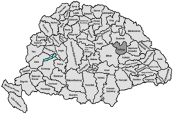
Szilágy county
|
Szilágy County (1910) |
|
|---|---|

|
|
| Administrative headquarters : | Zilah |
| Area : | 3,815 km² |
| Population : | 230.140 |
| Ethnic groups : | 59% Romanians 38% Hungarians 1.5% Slovaks 1.5% others |

|
|
The county Szilágy [ ˈsila Kom ] ( Hungarian Szilágy vármegye , Romanian Comitatul Sălaj ) was an administrative unit (county / county ) in royal Hungary .
location
The county bordered on the north with Sathmar (Szatmár) county , in the west with Bihar , in the south with Klausenburg (Kolozs) county and in the east with Szolnok-Doboka .
history
Belonging to the so-called Partium , the county was created in 1876 as part of an administrative reform in Transylvania from the previously existing counties Kraszna , Mittelollnock and part of Doboka county (around Agrij / Felsőegregy). By the Treaty of Trianon it was added to Romania in 1920 and existed as Sălaj County until 1960. Today it is largely in the Romanian Sălaj County , smaller parts in the northwest belong to the Satu Mare County and in the northeast to the Maramureş County .
District subdivision
In the early 20th century the following chair districts existed (named after the name of the administrative seat):
| Chair districts (járások) | |
|---|---|
| Chair district | Administrative headquarters |
| Kraszna | Kraszna, today Crasna |
| Szilágycseh | Szilágycseh, today Cehu Silvaniei |
| Szilágysomlyó | Szilágysomlyó, today Șimleu Silvaniei |
| Tasnád | Tasnád, today Tăşnad |
| Zilah | Zilah, today Zalau |
| Zsibó | Zsibó, today Jibou |
| City districts (rendezett tanácsú városok) | |
| Szilágysomlyó, today Șimleu Silvaniei | |
| Zilah, today Zalau | |
All places are in today's Romania .
See also
literature
- Szilágy . In: Meyers Konversations-Lexikon . 4th edition. Volume 15, Verlag des Bibliographisches Institut, Leipzig / Vienna 1885–1892, pp. 476–477.
Web links
- Entry in the Pallas Lexicon (Hungarian)
Individual evidence
- ↑ A magyar szent corona országainak 1910. évi népszámlálása . Budapest 1912, p. 12 ff.
- ↑ A magyar szent corona országainak 1910. évi népszámlálása . Budapest 1912, p. 22 ff. (1910 census)

