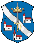
County bars
|
County Bars (Persch) (1910) |
|
|---|---|

|
|
| Administrative headquarters : | Aranyosmarót |
| Area : | 2,724 km² |
| Population : | 178,500 |
| Ethnic groups : | 55% Slovaks 35% Hungarians 10% Germans |

|
|
The County Bars (German rarely County perch ; Hungarian vármegye bars , Slovak Tekovská župa / stolica , Latin Comitatus Barsiensis ) is the name of a historic administrative unit ( county or county ) in the Kingdom of Hungary .
The area is in what is now central and southern Slovakia , the Slovak name Tekov is now used as an unofficial name for this area.
location
The county bordered Turz ( Turóc ) county to the east, north-east to Sohl ( Zólyom ) county , to the east to Hont county , to the east and south to Gran ( Esztergom ) county , to the south to Komorn ( Komárom ) and to the west and north to Neutra County ( Nyitra ).
It stretches along the river Gran (now Slovakian Hron ) and is in the east by the former Hont county , in the north by the places Kremnitz (now in Slovak Kremnica ) and Hronská Dúbrava (both belonging to the area), in the west by the river Žitava and bounded in the south by the towns of Bešeňov (belonging to the area) and Bíňa (not belonging to the area). The Gran and Žitava rivers flow through the area, and in 1910 there were 178,500 inhabitants in the county in an area of 2,724 km².
Administrative offices
Initially, the administrative headquarters on the was Castle perch in Stary Tekov , northwest of Levice (now Slovak Levice ), then on the castle Levice Levice, from the late 16th century in Topoľčianky and since the late 18th century in Zlaté Moravce .
history
The county was established in the 11th century. At the beginning of the 14th century, the area in the north was expanded at the expense of Sohl County . In 1918 the area became part of the newly formed Czechoslovakia , which was confirmed under international law by the Treaty of Trianon in 1920.
From 1938 to 1945 the southern half of the former county was occupied by Hungary due to the First Vienna Arbitration . The Hungarian part was combined with the southern part of the former Hont county, also Hungarian, to form Bars-Hont county , the capital of which was now the Hungarian Léva / Levice .
After the end of the Second World War , the area came back completely to Czechoslovakia , and after their disintegration into the Czech Republic and Slovakia in 1993, the landscape became part of Slovakia.
District subdivision
In the early 20th century, the county consisted of the following chair districts (named after the name of the administrative center):
| Chair districts (járások) | |
|---|---|
| Chair district | Administrative headquarters |
| Aranyosmarót | Aranyosmarót, today Zlaté Moravce |
| Verebély | Verebély, today Vráble |
| Léva | Léva, today Levice |
| Oszlány | Oszlány, today Oslany |
| Garamszentkereszt | Garamszentkereszt, today Žiar nad Hronom |
| City districts (rendezett tanácsú városok) | |
| Léva, today Levice | |
| Körmöcbánya, today Kremnica | |
| Újbánya, today Nová Baňa | |
See also
literature
- Bars . In: Meyers Konversations-Lexikon . 4th edition. Volume 2, Verlag des Bibliographisches Institut, Leipzig / Vienna 1885–1892, p. 397.
Web links
- Entry in the Pallas Lexicon (Hungarian)
Individual evidence
- ↑ A magyar szent corona országainak 1910. évi népszámlálása . Budapest 1912, p. 12 ff.
- ↑ A magyar szent corona országainak 1910. évi népszámlálása . Budapest 1912, p. 22 ff. (1910 census)

