
Levice
| Levice | |||
|---|---|---|---|
| coat of arms | map | ||

|
|
||
| Basic data | |||
| State : | Slovakia | ||
| Kraj : | Nitriansky kraj | ||
| Okres : | Levice | ||
| Region : | Nitra | ||
| Area : | 60.996 km² | ||
| Residents : | 32,735 (Dec. 31, 2019) | ||
| Population density : | 537 inhabitants per km² | ||
| Height : | 163 m nm | ||
| Postal code : | 934 01 | ||
| Telephone code : | 0 36 | ||
| Geographic location : | 48 ° 13 ' N , 18 ° 36' E | ||
| License plate : | LV | ||
| Kód obce : | 502031 | ||
| structure | |||
| Community type : | city | ||
| Urban area structure: | 4 districts and 9 cadastral municipalities | ||
| Administration (as of November 2018) | |||
| Mayor : | Ján Krtík | ||
| Address: | Mestský úrad Levice Námestie hrdinov 1 93401 Levice |
||
| Website: | www.levice.sk | ||
| Statistics information on statistics.sk | |||

Levice (German Lewenz , older also Lebentz and Levencz , Hungarian Léva ) is a city in western Slovakia and gives its name to the district of the same name.
location
The city lies in the open, hilly terrain of the northern Danube lowlands and is an economic center of the region.

history
The village was first mentioned in writing as Leua in 1156 and was the seat of the administration of Persch County from 1321 to 1580 .
Until 1918 the city belonged to the Kingdom of Hungary and then came to the newly formed Czechoslovakia . She came back to Hungary for a short time from 1938 to 1945 through the First Vienna Arbitration .
Residents
According to the 2001 census, 84.83% of the population were Slovaks. There were also 12.23% Hungarians, 1.04% Czechs and 0.36% Roma. According to denomination, the most widespread was the Roman Catholic Church with 58.76%, 22.77% described themselves as atheists, 7.46% were Protestants, 0.32% Greek Catholics and 3.4% of the residents gave no information.
Attractions
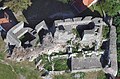
- Lewenz Castle from the 2nd half of the 13th century
- Catholic Josefskirche, from the 17th century
- Catholic parish church, built between 1773 and 1780 in the classical style
- Reformed and Evangelical Church (18th and 19th centuries)
- Synagogue , built in 1853

Aerial view


.jpg)
structure
The urban area is divided into 9 cadastral municipalities ( Čankov , Géňa , Horša , Kalinčiakovo , Krížny Vrch , Ladislavov Dvor , Levice , Malý Kiar , Nixbrod ), the city itself consists of the 4 districts Čankov (incorporated in 1986), Horša (incorporated in 1986), Kalinčiakovo (first mentioned in 1242 as "Wosyam"; formerly called "Varšany"; incorporated in 1976) and Malý Kiar (incorporated in 1976).
Twin cities
- Ruda Śląska (Poland)
Personalities
- Alexander Markus Beschorner (1823–1896), undertaker
- Ivan Čiernik (* 1977), Slovak ice hockey player
- Mikuláš Dušek (1913–1994), prehistoric
- Lajos Grendel (born April 6, 1948, † December 18, 2018), the most famous Hungarian writer in Slovakia
- Kálmán Kittenberger (born October 10, 1881), Hungarian researcher on Africa
- Pál Kadosa (1903–1983), Hungarian composer
See also
Individual evidence
- ↑ Partner and friendly cities ( memento of the original dated November 11, 2007 in the Internet Archive ) Info: The archive link was automatically inserted and not yet checked. Please check the original and archive link according to the instructions and then remove this notice. , accessed September 10, 2009.