Nims
| Nims | ||
|
Course of the Nims |
||
| Data | ||
| Water code | DE : 26288 | |
| location |
Eifel
|
|
| River system | Rhine | |
| Drain over | Prüm → Sauer → Moselle → Rhine → North Sea | |
| source | in the Eifel in the village of Weinsheim in a well on the street "Am Born" 50 ° 14 ′ 2 ″ N , 6 ° 28 ′ 25 ″ E |
|
| Source height | approx. 575 m above sea level NHN | |
| muzzle | at Irrel in the Prüm coordinates: 49 ° 50 ′ 41 ″ N , 6 ° 28 ′ 4 ″ E 49 ° 50 ′ 41 ″ N , 6 ° 28 ′ 4 ″ E |
|
| Mouth height | approx. 169 m above sea level NHN | |
| Height difference | approx. 406 m | |
| Bottom slope | approx. 6.6 ‰ | |
| length | 61.4 km | |
| Catchment area | 297.702 km² | |
| Discharge at the Alsdorf-Oberecken A Eo gauge: 263.9 km² Location: 6 km above the mouth |
NNQ (17.08.1996) MNQ 1957–2007 MQ 1957–2007 Mq 1957–2007 MHQ 1957–2007 HHQ (31.01.1961) |
318 l / s 648 l / s 2.83 m³ / s 10.7 l / (s km²) 46.7 m³ / s 122 m³ / s |
| Discharge at the mouth of the A Eo : 297.702 km² |
MQ Mq |
3.17 m³ / s 10.6 l / (s km²) |
| Small towns | Bitburg | |
|
The Nims near Schönecken in February 2004 |
||
|
The Nims spring in Weinsheim (2019) |
||
|
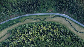
The Nims near Giesdorf, aerial photo (2015) |
||
|
Bridge saint Johannes von Nepomuk over the Nims in Seffern |
||
The Nims is a 61 km long orographically left tributary of the Prüm in the southern Eifel in the Rhineland-Palatinate Eifelkreis Bitburg-Prüm .
geography
course
The Nims rises at an altitude of about 575 m above sea level. NHN in Weinsheim (east of Prüm ), then runs in a south-westerly direction through the idyllic valley of the same name and flows below Irrel at about 169 m above sea level. NHN from the left into the Prüm.
Its approximately 61.4 km long course ends approximately 406 meters below the confluence of its source rivers, so it has an average bed gradient of approximately 6.6 ‰.
Tributaries
The longest tributaries of the Nims are
Tributaries over five kilometers in length
The tributaries on the left are shown in dark, the ones on the right in light blue.

places
The Nims flows through the places:
|
fauna
The Nims is known for the Eifel wild brook trout , which thrives due to the low pH value and cold water.
traffic
The partially dismantled Nims-Sauertal Railway, which is no longer operated today, ran through the southern section of the Nimstal (Messerich to Irrel) . Between Bickendorf and Seffern , the 781 m long Nimstalbrücke of federal highway 60 spans the valley of the Nims.
history
The Nims is mentioned as Nemesa by the poet Decim (i) us Magnus Ausonius in his work "Mosella" as far back as Roman times. Probably the next written mention of the river under the name Nimisa dates from the year 798 or 799 ("31st year of the reign of Charlemagne ").
Remarks
- ↑ In 1959 the US-American President Dwight D. Eisenhower enjoyed the noble Eifel fish during his visit to Bonn in the Hotel Königshof .
Individual evidence
- ↑ ZB Eiflia_illustrata Volume 3, Edition 2, Part 1, p. 169 ( books.google.de )
- ↑ a b Topographic map 1: 25,000
- ↑ a b GeoExplorer of the Rhineland-Palatinate Water Management Authority ( information )
- ↑ Level data from the LfU Rhineland-Palatinate
- ↑ Water level data from Alsdorf-Oberecken increased by the remaining catchment area (33.8 km²) with a (low estimated) Mq of 10 l / s km²
- ↑ Ausonius : The "Mosella" of Decimus Magnus Ausonius, Trier 1895, p. 52, line 354 ( dilibri.de )
- ↑ Heinrich Beyer : Document book on the history of the Middle Rhine territories now forming the Prussian administrative districts of Coblenz and Trier , 1860, supplement p. 6 ( dilibri.de )


